Report on Bezymianny (Russia) — June 1981
Scientific Event Alert Network Bulletin, vol. 6, no. 6 (June 1981)
Managing Editor: Lindsay McClelland.
Bezymianny (Russia) Large tephra cloud and lava flow
Please cite this report as:
Global Volcanism Program, 1981. Report on Bezymianny (Russia) (McClelland, L., ed.). Scientific Event Alert Network Bulletin, 6:6. Smithsonian Institution. https://doi.org/10.5479/si.GVP.SEAN198106-300250
Bezymianny
Russia
55.972°N, 160.595°E; summit elev. 2882 m
All times are local (unless otherwise noted)
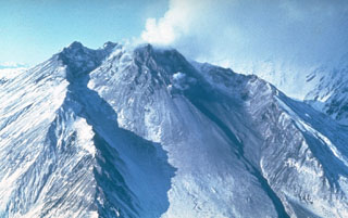
In a report dated 16 June, Tass said that Bezymianny had erupted, ejecting an 8-km-high ash column and extruding a lava flow 400 m wide. NESS personnel inspected early and mid June imagery returned every 3 hours from the GMS satellite, but did not find a large eruption column. Weather is often cloudy over Kamchatka, however, and could have masked evidence of an eruption.
Geological Summary. The modern Bezymianny, much smaller than its massive neighbors Kamen and Kliuchevskoi on the Kamchatka Peninsula, was formed about 4,700 years ago over a late-Pleistocene lava-dome complex and an edifice built about 11,000-7,000 years ago. Three periods of intensified activity have occurred during the past 3,000 years. The latest period, which was preceded by a 1,000-year quiescence, began with the dramatic 1955-56 eruption. This eruption, similar to that of St. Helens in 1980, produced a large open crater that was formed by collapse of the summit and an associated lateral blast. Subsequent episodic but ongoing lava-dome growth, accompanied by intermittent explosive activity and pyroclastic flows, has largely filled the 1956 crater.
Information Contacts: E. Hooper, NOAA/NESS; Tass