Report on Aira (Japan) — July 1981

Scientific Event Alert Network Bulletin, vol. 6, no. 7 (July 1981)
Managing Editor: Lindsay McClelland.
Aira (Japan) Explosions decline; seismic and eruptive activity since 1978 summarized
Please cite this report as:
Global Volcanism Program, 1981. Report on Aira (Japan) (McClelland, L., ed.). Scientific Event Alert Network Bulletin, 6:7. Smithsonian Institution. https://doi.org/10.5479/si.GVP.SEAN198107-282080
Aira
Japan
31.5772°N, 130.6589°E; summit elev. 1117 m
All times are local (unless otherwise noted)
During the first 27 days of July, only one explosion from the summit crater of Minami-dake was recorded by the JMA's Kagoshima Observatory. Ash ejection without recorded explosions and local seismicity also remained at low levels through July. Activity since January 1978 is summarized in figure 7.
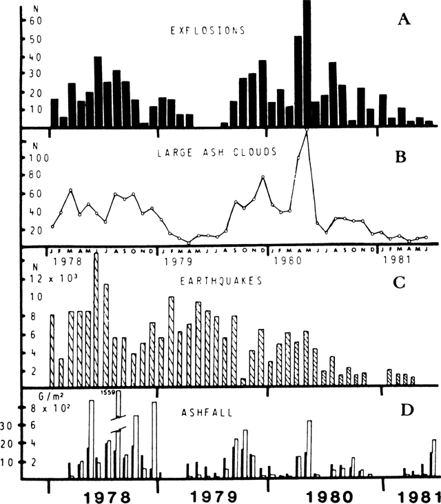 |
Figure 7. Activity at Sakura-jima during January 1978-June 1981, showing monthly number of recorded explosions (A), large ash clouds (B), recorded earthquakes (C), days when ashfall was observed at the Japan Meteorological Agency's Kagoshima Observatory, (D, black bars), and monthly volume of ash at Kagoshima Observatory (D, white bars). Ashfall is measured in a tray at Kagoshima Observatory. Explosions are counted by visual observation, microbarographs, and seismometers. Courtesy of JMA. |
Geological Summary. The Aira caldera in the northern half of Kagoshima Bay contains the post-caldera Sakurajima volcano, one of Japan's most active. Eruption of the voluminous Ito pyroclastic flow accompanied formation of the 17 x 23 km caldera about 22,000 years ago. The smaller Wakamiko caldera was formed during the early Holocene in the NE corner of the caldera, along with several post-caldera cones. The construction of Sakurajima began about 13,000 years ago on the southern rim and built an island that was joined to the Osumi Peninsula during the major explosive and effusive eruption of 1914. Activity at the Kitadake summit cone ended about 4,850 years ago, after which eruptions took place at Minamidake. Frequent eruptions since the 8th century have deposited ash on the city of Kagoshima, located across Kagoshima Bay only 8 km from the summit. The largest recorded eruption took place during 1471-76.
Information Contacts: JMA, Tokyo.