Report on St. Helens (United States) — July 1981

Scientific Event Alert Network Bulletin, vol. 6, no. 7 (July 1981)
Managing Editor: Lindsay McClelland.
St. Helens (United States) Occasional ash plumes to 3 km altitude
Please cite this report as:
Global Volcanism Program, 1981. Report on St. Helens (United States) (McClelland, L., ed.). Scientific Event Alert Network Bulletin, 6:7. Smithsonian Institution. https://doi.org/10.5479/si.GVP.SEAN198107-321050
St. Helens
United States
46.2°N, 122.18°W; summit elev. 2549 m
All times are local (unless otherwise noted)
The mid-June lobe (figure 17) was roughly comparable in volume to lobes emplaced during previous episodes last October, December-January, February, and April that built the pre-existing composite dome. A continuously recording tiltmeter about 30 m from the NE margin of the dome provided data on pre-extrusion uplift and probably recorded the beginning of extrusion at about 1700 on 18 June (figure 18). This tiltmeter was destroyed early 23 June, but three new tiltmeters were installed in early July, within 100 m of the NE, E, and SE sides of the dome. None showed any significant changes through July. Other July deformation measurements did not show the accelerating outward movement that has typically preceded extrusion episodes. The volume of SO2 emissions, measured by COSPEC from fixed-wing aircraft flying under the plume, usually ranged from 100 to 300 t/d during July, averaging about 150 t/d. Through the end of July there was no suggestion of the increase in SO2 emissions that preceded both the December 1980-January 1981 and the June 1981 lava extrusion episodes by several weeks. Poor weather precluded determination of SO2 trends before other extrusion episodes.
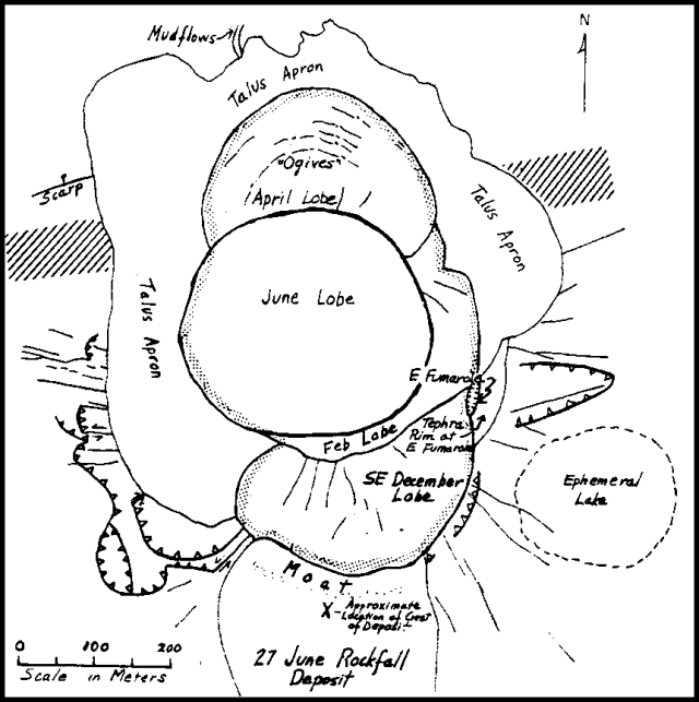 |
Figure 17. Sketch map of the June 1981 composite dome in the Mt. St. Helens crater, prepared by D. Swanson. The margins of the Mt. St. Helens dome are outlined by a stipple pattern. The approximate position of the N crater rampart is shown by a pattern of diagonal lines on each side of the talus apron. The tiltmeter just NE of the dome was destroyed by a rockfall 23 June 1981. |
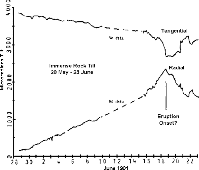 |
Figure 18. Data from the tangential and radial components of the continuously recording bubble tiltmeter, about 30 m NE of the margin of the dome, between its installation 29 May and its destruction by a rockfall 23 June 1981. Courtesy of D. Dzurisin. |
Occasional steam-and-ash emissions were observed during July and early August. An ash-laden gas plume rose to nearly 3 km altitude at 1453 on 9 July, accompanied by seismicity. A small ash plume just cleared the rim of the crater at 1138 on 14 July, and other plumes, accompanied by seismicity, were seen by USGS field crews at about 0845, 0948, 1442, and 1805 on 15 July, the largest reaching about 3 km altitude. A plume emerging from the February lobe of the composite dome reached 3 km altitude at 1257 on 16 July. Light ashfall was reported at Cougar between 0800 and 0900 on 27 July; this ash may have been ejected during a period of seismicity recorded at 0750. Five minutes of low-level tremor accompanied weak gas emission at 1605 on 28 July. An ash-laden plume rose to more than 3 km altitude at about 1805 on 30 July, accompanied by a seismic event and followed by about 5 minutes of low-level tremor. Several episodes of very low-level tremor were recorded 1-2 August. A characteristic burst of seismicity accompanied a plume, recorded on USFS video equipment at 0735 on 2 August, that appeared to be ash-laden and rose to about 3.5 km altitude. Several moderate seismic bursts at about 1905 on 3 August accompanied a small ash plume that reached 3.5 km altitude according to Portland Airport radar; 7 minutes of moderate tremor followed this ash emission. A small ash-laden gas emission occurred at 1133 on 4 August.
Geological Summary. Prior to 1980, Mount St. Helens was a conical volcano sometimes known as the Fujisan of America. During the 1980 eruption the upper 400 m of the summit was removed by slope failure, leaving a 2 x 3.5 km breached crater now partially filled by a lava dome. There have been nine major eruptive periods beginning about 40-50,000 years ago, and it has been the most active volcano in the Cascade Range during the Holocene. Prior to 2,200 years ago, tephra, lava domes, and pyroclastic flows were erupted, forming the older edifice, but few lava flows extended beyond the base of the volcano. The modern edifice consists of basaltic as well as andesitic and dacitic products from summit and flank vents. Eruptions in the 19th century originated from the Goat Rocks area on the N flank, and were witnessed by early settlers.
Information Contacts: D. Dzurisin, C. Newhall, D. Swanson, USGS, Vancouver, WA; W. Rose, Michigan Technological University; C. Boyko, S. Malone, E. Endo, C. Weaver, University of Washington; R. Tilling, USGS, Reston, VA.