Report on Guagua Pichincha (Ecuador) — September 1981
Scientific Event Alert Network Bulletin, vol. 6, no. 9 (September 1981)
Managing Editor: Lindsay McClelland.
Guagua Pichincha (Ecuador) Small phreatic explosions; felt earthquakes
Please cite this report as:
Global Volcanism Program, 1981. Report on Guagua Pichincha (Ecuador) (McClelland, L., ed.). Scientific Event Alert Network Bulletin, 6:9. Smithsonian Institution. https://doi.org/10.5479/si.GVP.SEAN198109-352020
Guagua Pichincha
Ecuador
0.171°S, 78.598°W; summit elev. 4784 m
All times are local (unless otherwise noted)
A small phreatic explosion that probably occurred in mid-August deposited fine tephra as much as 1 km SE of three new vents (3-8 m in diameter) in the summit crater. The new vents formed just E of a lava dome, about [625] m in diameter . . . . Aerial observers reported increased fumarolic activity in the summit crater about 20 August. Plume heights of as much as several hundred meters were reported in mid-August and a group that climbed the volcano 11-13 September observed a 200-300-m-high plume, but vapor emission had declined to only 2-3 times its normal level by early October. Temperatures of summit crater fumaroles in early October were 88-90°C, comparable to those recorded in 1976.
Seismographs at Quito and at Cotopaxi volcano (60 km to the SSE) recorded a series of earthquakes, some of which were large enough to be felt. However, the volcano is in a tectonically active zone and none of these events were large enough to be detected by the WWSSN. Earthquakes on 12 August at 0804 (probably centered near Quito) and 21 August at 0718 (probably centered about 40 km S of the volcano) had intensities of MM III-IV in Quito. Smaller events recorded on 25 August at 0651 and 26 August at 1311, both apparently centered about 40 km S of the volcano, were not felt, but residents of Quito noticed an event on 28 August at 1822 that probably had a nearby epicenter. Seismographs installed on the N, E, and S flanks 25-27 September had recorded no local seismicity (magnitude threshold about 1.5) as of 7 October. Dry-tilt stations were emplaced beginning 28 September at sites 11.25 km NNE, 9 km E, and 7.25 km SSW of the central dome.
A UNDRO volcanological team of John Tomblin, Karl Grönvold, and J.C. Sabroux assessed volcanic hazards in Ecuador 1-12 October. Chemical analyses of gas samples collected by Sabroux at Guagua Pichincha on 5 October will be compared to his analyses of gases collected from the same fumaroles in 1976.
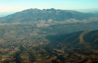
Geological Summary. Guagua Pichincha and the older Pleistocene Rucu Pichincha stratovolcanoes form a broad volcanic massif that rises immediately W of Ecuador's capital city, Quito. A lava dome grew at the head of a 6-km-wide scarp formed during a late-Pleistocene slope failure ~50,000 years ago. Subsequent late-Pleistocene and Holocene eruptions from the central vent consisted of explosive activity with pyroclastic flows accompanied by periodic growth and destruction of the lava dome. Many minor eruptions have been recorded since the mid-1500's; the largest took place in 1660, when ash fell over a 1,000 km radius and accumulated to 30 cm depth in Quito. Pyroclastic flows and surges also occurred, primarily to then W, and affected agricultural activity.
Information Contacts: M. Hall, Instituto Geofísico de la Escuela Politécnica Nacional; J.C. Sabroux, CNRS, Gif-sur-Yvette, France; National Earthquake Information Center, USGS.

