Report on Guagua Pichincha (Ecuador) — November 1981

Scientific Event Alert Network Bulletin, vol. 6, no. 11 (November 1981)
Managing Editor: Lindsay McClelland.
Guagua Pichincha (Ecuador) Minor ash ejection; local earthquakes
Please cite this report as:
Global Volcanism Program, 1981. Report on Guagua Pichincha (Ecuador) (McClelland, L., ed.). Scientific Event Alert Network Bulletin, 6:11. Smithsonian Institution. https://doi.org/10.5479/si.GVP.SEAN198111-352020
Guagua Pichincha
Ecuador
0.171°S, 78.598°W; summit elev. 4784 m
All times are local (unless otherwise noted)
In late August or early September, one or more small phreatic explosions ejected about 5,000 m3 of ash from five new vents, 2-12 m in diameter, on the NE flank of the central lava dome. Ash thicknesses decreased from more than 1 m adjacent to the vents to about 1 cm at 500 m to the E, and traces extended about halfway up the E inner wall of the crater. There was no evidence of any fresh magma in the ash. By early October, vapor emission from the explosion vents and a group of new fumaroles at the base of the S inner wall of the crater had declined to only 2-3 times its normal level.
Seismographs installed on the N, E, and S flanks of the volcano 25-27 September detected no local earthquakes until early October, but recorded several events in most 5-day periods between 1 October and 15 November (figure 1). The number of recorded events peaked at about 2/day in early November and had declined slightly to 4-6/week by early December. Three dry tilt stations were established on the flanks of the volcano in late September and two more were added in mid-November, but no significant change in tilt had been measured as of early December.
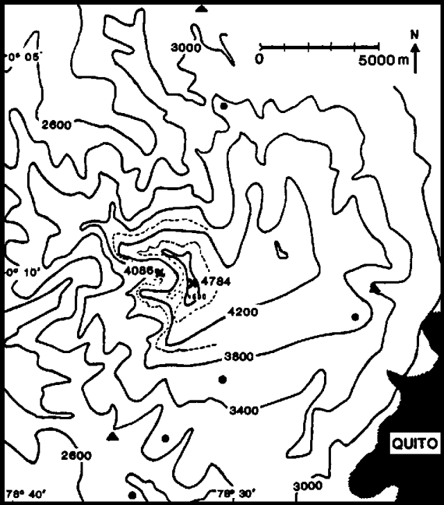 |
Figure 1. Map of Guagua Pichincha. Contour interval is 400 m except in the summit area, where 200-m contours are shown by dashed lines. The positions of dry-tilt stations are shown by solid circles, and seismographs are indicated by solid triangles. The area shaded at lower right is the city of Quito. Courtesy of M. Hall. |
Geologists climbed to the crater rim 3 December and noted that a small amount of ash had been deposited near the explosion vents since the area was last observed from the ground in mid-October. The volume of new ash appeared to be less than the estimated 5,000 m3 ejected in late August or early September. Steam emission had become more voluminous and two new vents had opened since October.
Geological Summary. Guagua Pichincha and the older Pleistocene Rucu Pichincha stratovolcanoes form a broad volcanic massif that rises immediately W of Ecuador's capital city, Quito. A lava dome grew at the head of a 6-km-wide scarp formed during a late-Pleistocene slope failure ~50,000 years ago. Subsequent late-Pleistocene and Holocene eruptions from the central vent consisted of explosive activity with pyroclastic flows accompanied by periodic growth and destruction of the lava dome. Many minor eruptions have been recorded since the mid-1500's; the largest took place in 1660, when ash fell over a 1,000 km radius and accumulated to 30 cm depth in Quito. Pyroclastic flows and surges also occurred, primarily to then W, and affected agricultural activity.
Information Contacts: M. Hall, Instituto Geofísico de la Escuela Politécnica Nacional; J. Tomblin, UNDRO.