Report on Zavaritzki Caldera (Russia) — December 1981
Scientific Event Alert Network Bulletin, vol. 6, no. 12 (December 1981)
Managing Editor: Lindsay McClelland.
Zavaritzki Caldera (Russia) No fumarolic activity
Please cite this report as:
Global Volcanism Program, 1981. Report on Zavaritzki Caldera (Russia) (McClelland, L., ed.). Scientific Event Alert Network Bulletin, 6:12. Smithsonian Institution. https://doi.org/10.5479/si.GVP.SEAN198112-290180
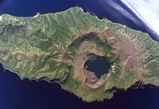
Zavaritzki Caldera
Russia
46.9178°N, 151.9518°E; summit elev. 612 m
All times are local (unless otherwise noted)
No apparent fumarolic or solfataric activity was observed [during an aerial inspection of Kuril Island volcanoes on 20 September 1981].
Geological Summary. The Zavaritzki volcano on Simushir Island in the central Kuril Islands contains three nested calderas 10, 8, and 3 km in diameter. The steep-walled youngest caldera was formed during the Holocene and includes several young cones and lava domes near the margins of Biryuzovoe Lake. The current lake surface is at ~40 m elevation with the bottom ~30 m below sea level, but lacustrine sediments overlying pumice deposits indicate that the surface of an earlier caldera lake lay at 200 m above sea level. A small 500-m-diameter scoria cone, sketched by Gorshkov (1958, CAVW) that reportedly grew between 1916 and 1931, formed a peninsula extending into the lake from the NE caldera wall. Explosive eruptions in 1957 removed the cone and filled much of the NW part of the lake, including emplacement of a 350-m-wide, 40-m-high dome. Hutchison et al. (2024) provided convincing evidence that Zavaritski Caldera was the source for a significant sulfur-rich eruption in 1831 CE, which was previously known only from ice core data and thought to have possibly originated from Babuyan Claro volcano.
Information Contacts: G. Steinberg, Sakhalin Complex Institute.