Report on Pagan (United States) — February 1982
Scientific Event Alert Network Bulletin, vol. 7, no. 2 (February 1982)
Managing Editor: Lindsay McClelland.
Pagan (United States) Explosions resume
Please cite this report as:
Global Volcanism Program, 1982. Report on Pagan (United States) (McClelland, L., ed.). Scientific Event Alert Network Bulletin, 7:2. Smithsonian Institution. https://doi.org/10.5479/si.GVP.SEAN198202-284170
Pagan
United States
18.13°N, 145.8°E; summit elev. 570 m
All times are local (unless otherwise noted)
Residents of Agrigan Island, about 50 km NNW of Pagan, observed voluminous black columns rising from the volcano on 4, 5, and 6 January, and white plumes on other days in the first half of January. Telefax copies of thermal infrared imagery (8 km resolution), available at 3-hour intervals from the GMS were inspected at the NOAA/NESS, but no eruption cloud was apparent despite clear weather. The activity was preceded by three deep earthquakes near Pagan, on 3 January at 2005, 2009, and 2015. NEIS located preliminary hypocenters at 18.034°N, 145.633°E, 590 km deep (M 6.1); 17.903°N, 145.530°E, 513 km deep (M 5.8); and 18.166°N, 145.352°E, 596 km deep (M 5.4). The first event was felt on Saipan (about 180 km S of Pagan) and Guam (nearly 300 km SSW of Pagan).
No additional activity was reported until 8 February, when the mayor of the northern islands visited Pagan and found it erupting. A minimum of five minor eruptions per day were observed through 23 February. At one point during this period (date and time not yet determined), a "large smoke cover" from Pagan was observed over Saipan. Images of the area, returned by the NOAA 7 polar orbiting satellite 1-2 times per day, were inspected 25 January-25 February, but no eruption plumes were evident. In hand specimen, a sample of ejecta collected 17 February appeared to contain at least 30% non-juvenile material. The sample will be analyzed at HVO.
The 53 residents of Pagan, evacuated during the second day of the 1981 eruption, have not yet been able to return for more than brief visits to the island.
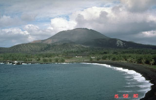
Geological Summary. Pagan Island, the largest and one of the most active of the Mariana Islands volcanoes, consists of two stratovolcanoes connected by a narrow isthmus. Both North and South Pagan stratovolcanoes were constructed within calderas, 7 and 4 km in diameter, respectively. North Pagan at the NE end of the island rises above the flat floor of the northern caldera, which may have formed less than 1,000 years ago. South Pagan is a stratovolcano with an elongated summit containing four distinct craters. Almost all of the recorded eruptions, which date back to the 17th century, have originated from North Pagan. The largest eruption during historical time took place in 1981 and prompted the evacuation of the sparsely populated island.
Information Contacts: N. Banks, HVO; Cmdr. J. Walker, COMNAVMAR; L. Whitney, Office of the Rep. to the U.S., Washington DC; USGS/NEIS, Denver CO; M. Matson, NOAA/NESS.