Report on Galunggung (Indonesia) — March 1982
Scientific Event Alert Network Bulletin, vol. 7, no. 3 (March 1982)
Managing Editor: Lindsay McClelland.
Galunggung (Indonesia) Heavy ashfall; mudflows; eight killed
Please cite this report as:
Global Volcanism Program, 1982. Report on Galunggung (Indonesia) (McClelland, L., ed.). Scientific Event Alert Network Bulletin, 7:3. Smithsonian Institution. https://doi.org/10.5479/si.GVP.SEAN198203-263140
Galunggung
Indonesia
7.25°S, 108.058°E; summit elev. 2168 m
All times are local (unless otherwise noted)
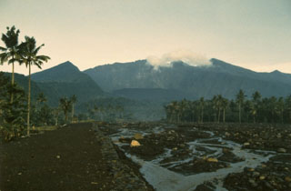
A brief explosive eruption began before dawn 5 April, ejecting incandescent tephra and "stones as big as a human head" according to press reports. An image returned at 0700 by the Japanese geostationary weather satellite showed an eruption column about 50 km in diameter. The next available image, at 1410, showed that feeding of the eruption column had stopped and the plume had drifted about 250 km to the N. As much as 25 cm of ash fell on the flanks and ashfalls were reported from as far away as Garut, 35 km to the NW. The activity was accompanied by strong felt seismicity, and felt events continued in midafternoon. Two persons were killed and as many as 31,000 were evacuated, but most of the evacuees returned home within a few hours.
A second explosive eruption occurred during the night of 8-9 April, associated with at least one felt earthquake. Hot mud flowed at 60 km/hour as far as 11 km down the SE flank, buried houses in at least six villages, and destroyed a bridge over the Cikunir River, which emerges from a large breach in the SE side of the crater (figure 1). Officials said that only about half of the 8.6 x 10⁶ m3 of material in the crater had been ejected and feared that the steady rain falling on the area could trigger more mudflows. AFP reported eight persons dead, three missing, and 22 injured. UPI reported that many were burned or suffering from the effects of toxic volcanic gases. Authorities have forbidden entry into several areas where gases were seeping from cracks in the ground. The rice crop, within a month of its harvest, was destroyed.
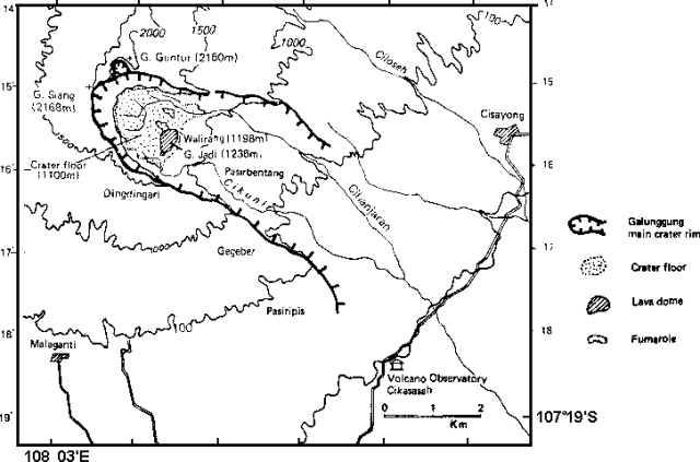 |
Figure 1. Sketch map of Galunggung crater and vicinity, showing the Gaunug Jadi lava dome, Walirang ridge, major drainages, and flank towns. A temporary volcano observatory was established in Cikasasah, 7 km SE of the crater. From Katili and Sudradjat, 1984. |
Geological Summary. The forested slopes of Galunggung in western Java SE of Bandung are cut by a 2-km-wide collapse scarp open towards the ESE. The "Ten Thousand Hills of Tasikmalaya" dotting the plain below the volcano are debris-avalanche hummocks from the collapse about 4,200 years ago. An eruption in 1822 produced pyroclastic flows and lahars that killed over 4,000 people. A series of major explosive eruptions starting in April 1982 destroyed a number of villages, killed as many as 30 people, and forced over 60,000 to evacuate. Pyroclastic flows and heavy widespread ash caused significant damage. A large passenger jet that encountered the ash plume on 24 June lost power to all four engines but managed to land safely in Jakarta. The 1982 activity destroyed a 1918 dome and formed the Warirang crater, almost as wide as the valley, about 2 km down from the summit.
Information Contacts: D. Haller, NOAA; C. Dan Miller, USGS; Jakarta DRS; AFP; UPI.