Report on Ruapehu (New Zealand) — June 1982

Scientific Event Alert Network Bulletin, vol. 7, no. 6 (June 1982)
Managing Editor: Lindsay McClelland.
Ruapehu (New Zealand) Lake temperature and level drop; no new explosions
Please cite this report as:
Global Volcanism Program, 1982. Report on Ruapehu (New Zealand) (McClelland, L., ed.). Scientific Event Alert Network Bulletin, 7:6. Smithsonian Institution. https://doi.org/10.5479/si.GVP.SEAN198206-241100
Ruapehu
New Zealand
39.28°S, 175.57°E; summit elev. 2797 m
All times are local (unless otherwise noted)
NZGS personnel surveying Ruapehu on 29 May observed no hydrothermal eruptions from Crater Lake during their 8-hour stay, nor did they see evidence of recent large surges of lake water in the heavy snow cover within 1-2 m of the water's edge. The lake level was lower than on the 15 and 21 April visits; measurements indicated it was 2 m below overflow, the lowest since the April 1975 eruption. Bathymetric surveys had shown a decrease in the depth to the vent area of about 250 m between 1965 and 1970 but data collected from remote depth sounding buoys in 1982 indicated that the vent area was about 150 m deeper than in 1970. Water temperature in the outlet area was 27°C, 15° lower than on 21 April (figure 5). A large yellow-black sulfur slick usually occupied the center of the battleship gray lake. Chemical analysis of lake water showed small increases in Mg and Cl concentrations, but no change in the Mg/Cl ratio.
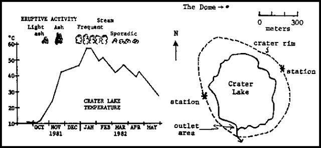 |
Figure 5. Temperature of Crater Lake at Ruapehu as measured in the Outlet area (left), and sketch of the crater area showing measurement sites used to collect data (right). Courtesy of P. Otway. |
Deformation surveys of the volcano showed no measurable tilt, but an increase of about 10 mm, since 21 April, in a precisely measured 600-m line across the crater. About 10 µrad of inflation have occurred since the latter half of 1981, and the crater was about 20 mm wider than a year ago (figure 6). NZGS interpreted the slight inflation as either non-elastic expansion possibly related to the eruptive period that began late in 1981 (06:10-12), or still-elevated gas pressure within the vent.
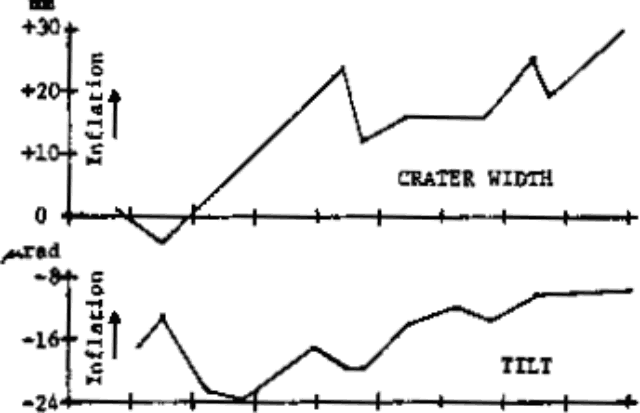 |
Figure 6. Ruapehu crater width as measured October 1981-May 1982 between two stations ~600 m apart on the crater rim (top), and tilt as measured from the Dome, ~200 m N of the crater rim (bottom). Courtesy of P. Otway. |
Geological Summary. Ruapehu, one of New Zealand's most active volcanoes, is a complex stratovolcano constructed during at least four cone-building episodes dating back to about 200,000 years ago. The dominantly andesitic 110 km3 volcanic massif is elongated in a NNE-SSW direction and surrounded by another 100 km3 ring plain of volcaniclastic debris, including the NW-flank Murimoto debris-avalanche deposit. A series of subplinian eruptions took place between about 22,600 and 10,000 years ago, but pyroclastic flows have been infrequent. The broad summait area and flank contain at least six vents active during the Holocene. Frequent mild-to-moderate explosive eruptions have been recorded from the Te Wai a-Moe (Crater Lake) vent, and tephra characteristics suggest that the crater lake may have formed as recently as 3,000 years ago. Lahars resulting from phreatic eruptions at the summit crater lake are a hazard to a ski area on the upper flanks and lower river valleys.
Information Contacts: P. Otway, NZGS, Wairakei; I. Nairn, NZGS, Rotorua.