Report on Cameroon (Cameroon) — November 1982
Scientific Event Alert Network Bulletin, vol. 7, no. 11 (November 1982)
Managing Editor: Lindsay McClelland.
Cameroon (Cameroon) Strombolian activity; lava flows; landsliding
Please cite this report as:
Global Volcanism Program, 1982. Report on Cameroon (Cameroon) (McClelland, L., ed.). Scientific Event Alert Network Bulletin, 7:11. Smithsonian Institution. https://doi.org/10.5479/si.GVP.SEAN198211-224010
Cameroon
Cameroon
4.203°N, 9.17°E; summit elev. 4095 m
All times are local (unless otherwise noted)
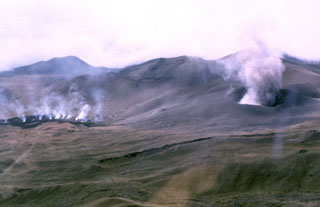
The upper SW flank fissure eruption that began 16 October ended by 10 November. When French volcanologists departed at the end of October, lava was continuing to emerge from the lower part of the fissure while strombolian activity built a scoria conescoria cone less than 1 km upslope.
Between 31 October and the 7 November arrival of British volcanologists, there was extensive landsliding around the lower part of the fissure. An elongate depression had formed, trending radially downslope,~ 500 m long, 200 m wide, and as much as 150 m deep. An estimated 5 x 10⁶ m3 of old lava and pyroclastics moved a maximum of 1.5 km. Lava from later stages of the eruption flowed over and around the debris pile, entering the rain forest 2 km from the vent.
When Fitton, Kilburn, and Hughes arrived at the volcano 7 November, activity from the lower part of the fissure had stopped. However, moderate strombolian activity was continuing from the upper part of the fissure, ejecting bombs as much as 50 cm in diameter to 100 m above the rim of the scoria cone, which was 50 m high and 150 m across. Lava flowed from a vent below the SW side of the cone at 2,700 m altitude. The next day, a velocity of 2 m/s was measured in a 2-m-wide flow from the vent. At 2,600 m altitude, this lava formed an aa flow 3 m wide, advancing 1-4 m/s. At the flow front, 1 km from the vent, the temperature of the lava was 1,070°C. On 9 November, lava emission had slowed to a very sluggish trickle and activity at the cone was reduced to gas emission with a period of 5-15 minutes. The eruption had apparently ceased by 10 November.
Further Reference. Fitton, J.G., Kilburn, C.R.J., Thirlwall, M.F., and Hughes, D.J., 1983, 1982 Eruption of Mount Cameroon, West Africa: Nature, v. 306, p. 327-332.
Geological Summary. Mount Cameroon, one of Africa's largest volcanoes, rises above the coast of west Cameroon. The massive steep-sided volcano of dominantly basaltic-to-trachybasaltic composition forms a volcanic horst constructed above a basement of Precambrian metamorphic rocks covered with Cretaceous to Quaternary sediments. More than 100 small cinder cones, often fissure-controlled parallel to the long axis of the 1400 km3 edifice, occur on the flanks and surrounding lowlands. A large satellitic peak, Etinde (also known as Little Cameroon), is located on the S flank near the coast. Historical activity was first observed in the 5th century BCE by the Carthaginian navigator Hannon. During historical time, moderate explosive and effusive eruptions have occurred from both summit and flank vents. A 1922 SW-flank eruption produced a lava flow that reached the Atlantic coast, and a lava flow from a 1999 south-flank eruption stopped only 200 m from the sea. Explosive activity from two vents on the upper SE flank was reported in May 2000.
Information Contacts: G. Fitton, Univ. of Edinburgh; C. Kilburn, Univ. of London; D. Hughes, Portsmouth Polytechnic.