Report on Galunggung (Indonesia) — December 1982
Scientific Event Alert Network Bulletin, vol. 7, no. 12 (December 1982)
Managing Editor: Lindsay McClelland.
Galunggung (Indonesia) Tephra ejection continues; new cone
Please cite this report as:
Global Volcanism Program, 1982. Report on Galunggung (Indonesia) (McClelland, L., ed.). Scientific Event Alert Network Bulletin, 7:12. Smithsonian Institution. https://doi.org/10.5479/si.GVP.SEAN198212-263140
Galunggung
Indonesia
7.25°S, 108.058°E; summit elev. 2168 m
All times are local (unless otherwise noted)
VSI reported that tephra ejection continued through mid-Jan, but with consistently decreasing intensity. Three explosions were reported in November, two in December, and one in the first half of January. Ash columns rose to ~ 3-5 km in November and December and to about 2 km in January. Glows, frequently observed during the December and January explosions, lasted for several hours to several days. Indonesian air traffic control authorities reported explosive activity on 4 January at 1900 and issued an alert to aviation.
Within the 1982-83 crater, a tephra cone ~200 m in diameter and 70-80 m high has developed in the area once occupied by the 1918 lava dome (Gunung Jadi). A 20-30-m-diameter vent in the new cone ejected pyroclastics to several tens of meters height. Strombolian activity occurred from this vent in January.
The Department of Public Works has controlled lahars along the Cikunir, Cibanjaran, and Ciloseh rivers by constructing a series of dikes and pocket dams 5-7 km long, concentric and radial to the active crater. As of mid-Jan, the dikes had stopped lahars from reaching the city of Tasikmalaya, population 700,000.
Press sources reported that on 9 October at 1111 Galunggung ejected a thick grayish cloud to 800 m height. At a VSI observation post on the flank, tremor amplitude reached a maximum of 45 mm. About 15 minutes later, a second explosion produced a 1 km-high cloud. The much larger explosion that followed generated a dense eruption column that reached a height of 8 km and was accompanied by lightning and thunderous sounds. At about 1610 a fourth explosion ejected sand-sized tephra that caused the collapse of 60 houses in a nearby village. Rainfall later that afternoon washed ash from house roofs in Tasikmalaya.
The 3 December explosion began at 1730. The activity began with a thunderous sound and ejection of incandescent material from the crater. Tremor amplitude at the VSI observation post increased from 25 mm to 41 mm. By 1820 lahars were flowing down 2 rivers. Large glows and frequent lightning were visible from Tasikmalaya. Ash blew to the W and 2 cm was deposited in the vicinity of Garut.
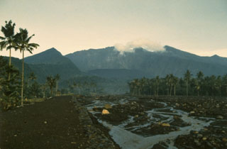
Geological Summary. The forested slopes of Galunggung in western Java SE of Bandung are cut by a 2-km-wide collapse scarp open towards the ESE. The "Ten Thousand Hills of Tasikmalaya" dotting the plain below the volcano are debris-avalanche hummocks from the collapse about 4,200 years ago. An eruption in 1822 produced pyroclastic flows and lahars that killed over 4,000 people. A series of major explosive eruptions starting in April 1982 destroyed a number of villages, killed as many as 30 people, and forced over 60,000 to evacuate. Pyroclastic flows and heavy widespread ash caused significant damage. A large passenger jet that encountered the ash plume on 24 June lost power to all four engines but managed to land safely in Jakarta. The 1982 activity destroyed a 1918 dome and formed the Warirang crater, almost as wide as the valley, about 2 km down from the summit.
Information Contacts: A. Sudradjat and O. Mandraguna, VSI; W. Smith, FAA; M. Krafft, Cernay; Kompas and Sinar Harapan, Jakarta.