Report on Mauna Loa (United States) — May 1983
Scientific Event Alert Network Bulletin, vol. 8, no. 5 (May 1983)
Managing Editor: Lindsay McClelland.
Mauna Loa (United States) Seismicity and summit caldera deformation increase
Please cite this report as:
Global Volcanism Program, 1983. Report on Mauna Loa (United States) (McClelland, L., ed.). Scientific Event Alert Network Bulletin, 8:5. Smithsonian Institution. https://doi.org/10.5479/si.GVP.SEAN198305-332020
Mauna Loa
United States
19.475°N, 155.608°W; summit elev. 4170 m
All times are local (unless otherwise noted)
"Mauna Loa last erupted in July 1975. That eruption was preceded by an increase in both shallow and intermediate-depth earthquakes, and by extension of survey lines across the caldera (figure 1, left). Since 1980, and especially since early 1983, the number of shallow earthquakes beneath Mauna Loa has been increasing again. Intermediate-depth earthquakes have continued at a higher rate during the period from 1978 to present than during 1971-73, but have not shown the same pattern of increase as they did in 1974 (figure 1, right). Figure 1 also shows a recent increase in the rate of extension of survey lines across the summit caldera.
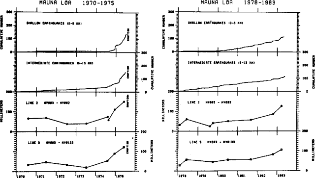 |
Figure 1. Plot of cumulative number of local earthquakes at shallow (0-5 km) and intermediate (5-13 km) depths, and extension (in mm) on two survey lines across the summit caldera, for 1970-75 (left), and 1978-83 (right). |
"The recent rate of strain from apparent intrusion of magma beneath the summit region shows an increasing trend from both seismic and ground surface deformation data. The present strength of the summit region is not known, so no precise forecast of the next eruption can be made. However, the present seismic and deformation data indicate a significantly increased probability of eruption of Mauna Loa during 1983 or 1984."
Geological Summary. Massive Mauna Loa is a basaltic shield volcano that rises almost 9 km from the ocean floor to form the world's largest Holocene volcano. Flank eruptions typically occur from the lengthy NE and SW rift zones, and from the Moku'aweoweo summit is caldera, which is within an older and larger 6 x 8 km caldera. Two of the youngest large debris avalanches documented in Hawaii traveled nearly 100 km from Mauna Loa; the second of the Alika avalanches was emplaced about 105,000 years ago (Moore et al., 1989). Almost 90% of the surface of the volcano is covered by lavas less than 4,000 years old (Lockwood and Lipman, 1987). Beginning about 1,500 years ago, a series of voluminous overflows from a summit lava lake covered about 25% of the volcano's surface. Over the last 750 years, from shortly after the formation of Moku'aweoweo caldera until the present, an additional 25% of the volcano has been covered with lava flows, mainly from summit and NW rift zone vents.
Information Contacts: R. Decker, R. Koyanagi, and J. Dvorak, HVO, Hawaii.