Report on Veniaminof (United States) — June 1983

Scientific Event Alert Network Bulletin, vol. 8, no. 6 (June 1983)
Managing Editor: Lindsay McClelland.
Veniaminof (United States) Lava flows melt holes in caldera ice; increased ash emission
Please cite this report as:
Global Volcanism Program, 1983. Report on Veniaminof (United States) (McClelland, L., ed.). Scientific Event Alert Network Bulletin, 8:6. Smithsonian Institution. https://doi.org/10.5479/si.GVP.SEAN198306-312070
Veniaminof
United States
56.17°N, 159.38°W; summit elev. 2507 m
All times are local (unless otherwise noted)
The eruption was continuing in early July. Periods of poor weather frequently limited observations, but eruption plumes were sometimes visible above low clouds mantling the volcano's summit.
By the time of a USGS overflight 15 June, the eruption had built a new cinder cone, roughly 150 m high and 500 m in diameter, within the central crater of the pre-existing 300 m-high cone in the S part of the 10 km-diameter ice-filled caldera (figure 2). Every few seconds, rhythmic explosions ejected molten material from the central vent of the new cone. However, the lava flow that had been cascading down the S side of the cone onto the ice on 9 June (figure 3) was no longer active. This flow had formed a large pit in the ice, approximately 250-300 m in diameter and roughly 60 m deep. Steam rose from numerous point sources within the pit. In the ice just SE of the cone, a new pit roughly 60 m across had developed, along the trend of what appeared to be fractures on the cone. Vapor clouds from the pit seemed to be emerging from a cavern in the portion nearest the cone, suggesting that a flank eruption may have been occurring beneath the ice. From the central vent, voluminous steam emission fed billowing white clouds that rose to about 3.5 km altitude. Vigorous steaming had been observed after dark on 11 June but the activity was distinctly stronger on the 15th. Only minor ash emission was observed, although thin tephra deposits surrounded the volcano, perhaps reaching a thickness of a few centimeters SW of the cone.
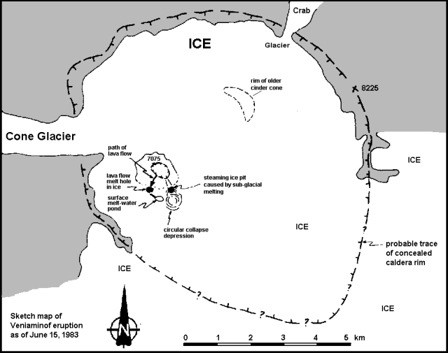 |
Figure 2. Sketch map by M. Elizabeth Yount showing Veniaminof's crater on 15 June 1983. |
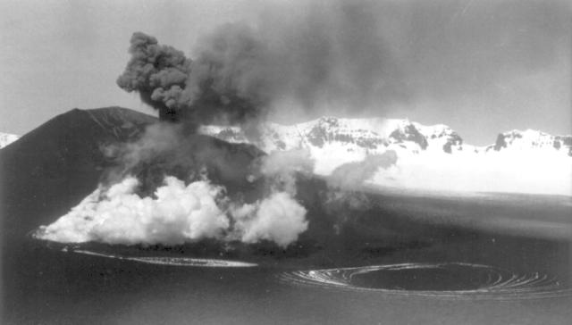 |
Figure 3. Photograph of Veniaminof from the SW, on 9 June 1983 between 1515 and 1600. The circular collapse depression is shown in right foreground, the meltwater pond to its left. Steam emerges from the hole melted by the lava flow in the ice at the base of the cone. Ash is being ejected from the active cone. The caldera ice is covered by a thin layer of ash. The snow-covered caldera rim is visible in the background, with the notch at right leading to Crab Glacier (figure 2). The steaming ice pit, shown on figure 2 and described above, formed after this photo was taken. Courtesy of USGS. |
A pilot who flew over the summit on 17 June at 1700 saw no lava fountaining and reported that lava was flowing down the SW side of the cone at a diminished rate. Beginning 21 June, pilots frequently observed ash plumes penetrating the layer of low clouds that usually obscured the crater. Around mid-morning on the 21st, a plume reached an estimated 2.5 km altitude (only about 300 m above the active cone). Early 25 June, ash was moving NE at 3.5-4 km altitude and several ash puffs were observed that afternoon. During a few hours of clear weather on the afternoon of 27 June, lava was fountaining to about 100 m above the cone and an active flow was observed.
A lake about 1.5 km long was seen on the ice filling the caldera. Early on 28 June, pilots reported dense ash clouds moving NW at altitudes as high as 6 km. At 1500, an ash burst reached 8 km altitude; ash was rising to 6 km at 1715 and ash and steam to 4.5 km at 2139. Late on 29 June, a pilot reported ash and larger tephra being ejected at a high rate, feeding a plume that moved NW and reached 5.5-6 km altitude. During the first week in July, plumes typically rose to a maximum of 3.5-4.5 km, but higher weather clouds often prevented pilots from seeing eruption plumes. Images from the NOAA 7 polar orbiting satellite showed the development of a plume that had started forming shortly before an image on 4 July at about 1130. At 1623, the plume extended about 150 km to the SSE and analysis of infrared data yielded a minimum plume temperature of -8°C. Radiosonde temperature/altitude profiles indicated that this temperature corresponded to an altitude of 3.8 km. By 2000, no plume could be seen.
Renewed lava flow activity was observed in early July, from a vent near the summit of the cone, and perhaps from a new vent on its SE flank. On 7 and 8 July, lava fountaining was continuing and bombs rose to about 100 m above the cone.
Last month, we reported that Veniaminof last erupted in 1944. However, a small cone shown in a 1954 airphoto had disappeared by 1973, when USGS personnel carried out field work at Veniaminof, and geologists presume that an eruption must have destroyed it at some time during this 19-year period. The cone was within the 300-m-high cone, active in the current eruption, in the S part of the caldera. Efforts to locate more photographs and narrow the 19-year time window are continuing.
Geological Summary. Veniaminof, on the Alaska Peninsula, is truncated by a steep-walled, 8 x 11 km, glacier-filled caldera that formed around 3,700 years ago. The caldera rim is up to 520 m high on the north, is deeply notched on the west by Cone Glacier, and is covered by an ice sheet on the south. Post-caldera vents are located along a NW-SE zone bisecting the caldera that extends 55 km from near the Bering Sea coast, across the caldera, and down the Pacific flank. Historical eruptions probably all originated from the westernmost and most prominent of two intra-caldera cones, which rises about 300 m above the surrounding icefield. The other cone is larger, and has a summit crater or caldera that may reach 2.5 km in diameter, but is more subdued and barely rises above the glacier surface.
Information Contacts: T. Miller and M.E. Yount, USGS, Anchorage; M. Matson and D. Haller, NOAA/NESDIS.