Report on Colo (Indonesia) — August 1983
Scientific Event Alert Network Bulletin, vol. 8, no. 8 (August 1983)
Managing Editor: Lindsay McClelland.
Colo (Indonesia) Continued explosive activity seen on satellite images; numerous magnitude 5 earthquakes
Please cite this report as:
Global Volcanism Program, 1983. Report on Colo (Indonesia) (McClelland, L., ed.). Scientific Event Alert Network Bulletin, 8:8. Smithsonian Institution. https://doi.org/10.5479/si.GVP.SEAN198308-266010
Colo
Indonesia
0.162°S, 121.601°E; summit elev. 404 m
All times are local (unless otherwise noted)
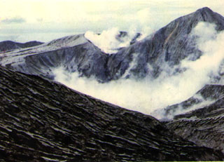
Satellite images continued to show occasional eruption plumes through late August. After the 12 August plume described last month, activity was next observed on an image from the GMS satellite on 22 August at 1400, when a very small fairly bright area was present directly over the island, a feature typical of the initial stages of an explosive episode. This event developed rapidly with a NOAA 7 image 35 minutes later showing a bright plume extending about 60 km to the W. By 1700 (GMS data), it had moved about 120 km W from the volcano, and its leading edge had just reached the coast of Sulawesi. On the next image, at 2000, feeding from the volcano appeared to have ended and the plume was dissipating to the W. On 26 August at 1100, a GMS image showed a bright, newly-ejected plume about 40 km wide that appeared to have reached the tropopause. At 1400, a very dense high-level cloud about 80 km wide had spread W then SW about 250 km, but on a NOAA 7 image 1 hour later the cloud appeared to be dispersing and the eruption had clearly ceased by the next GMS image at 1700. On 29 August, GMS imageryshowed the beginning of an explosive episode at about 1930. By midnight, a moderately dense plume extended WSW along the equator, then turned abruptly to the SSW, reaching 120°E at 1-2°S. On the next image, at 0500, feeding from the volcano had stopped and the plume was nearly dissipated.
Government officials noted that several villages [were] completely destroyed by the eruption and that all of the island's coconut trees had been killed. All of the people living on Una Una were evacuated before the devastating explosions 23 July. Officials anticipated that it would be several years before the island would again be habitable, so residents have been resettled on other islands until they can return.
The WWSSN noted 66 events in the vicinity of Una Una beginning late 16 July. No earthquakes smaller than M 4.5 were tabulated, and most magnitudes were between 4.8 and 5.4. Of these, the 21 recorded by 20 or more stations had a mean epicenter of 0.09°S, 121.70°E (standard deviations for both latitude and longitude, 0.05°), about 15 km NE of the volcano. Depths of the same 21 events avaraged 55 km (standard deviation 7.5 km). Earthquakes recorded by the WWSSN had become less frequent by the time of the largest explosion 23 July; few were recorded after 26 July and none after 1 August. Other events in the region included single M 5.0-5.3 shocks on 27, 28, and 31 July, about 200 km ENE of Una Una at roughly 40 km depth; and M 5.5 and 5.1 earthquakes 20 and 31 July at depths of 299 and 272 km, 300 km WNW of the volcano.
Geological Summary. Colo volcano forms the isolated small island of Una Una in the middle of the Gulf of Tomini in northern Sulawesi. The broad, low volcano contains a 2-km-wide caldera with a small central cone. Three eruptions have been recorded since the late 1800's, but two of those caused widespread damage over the island. The last eruption, in 1983, produced pyroclastic flows that swept over most of the island shortly after all residents had been evacuated.
Information Contacts: M. Matson, J. Hawkins, and S. Kusselson, NOAA/NESDIS; NEIC; Antara News Agency, Jakarta.