Report on Miyakejima (Japan) — September 1983
Scientific Event Alert Network Bulletin, vol. 8, no. 9 (September 1983)
Managing Editor: Lindsay McClelland.
Miyakejima (Japan) Tephra cloud to 10 km; lava flows from fissure vents destroy town; 2,000 evacuated
Please cite this report as:
Global Volcanism Program, 1983. Report on Miyakejima (Japan) (McClelland, L., ed.). Scientific Event Alert Network Bulletin, 8:9. Smithsonian Institution. https://doi.org/10.5479/si.GVP.SEAN198309-284040
Miyakejima
Japan
34.094°N, 139.526°E; summit elev. 775 m
All times are local (unless otherwise noted)
Miyake-jima erupted on 3 October after 21 years of quiescence. Two hours of increasing seismicity preceded the eruption onset. A column of tephra and vapor rose to 10 km, and lava flowed down the SW flank.
Small earthquakes began to be recorded at the JMA Miyake-jima Weather Station at [1359]. Weak shocks were felt at the same time in Ako, the largest village on the SW coast. Seismicity increased gradually, and from around 1430 to 1523 as many as 2-3 earthquakes per minute were recorded. The first felt shock (JMA intensity 1) at the weather station occurred at [1447], followed by others at 1500 (JMA 2), 1514 (JMA 1), and 2 at 1522 (both JMA 2). Many more shocks were felt in Ako. JMA personnel judged that the eruption began at 1523, when the amplitude of recorded continuous tremor began to increase. Tremor saturated the seismograph by [1529] and high amplitudes persisted for hours.
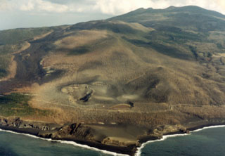
The eruption began [near Jinan-yama, 2 km SW of the summit, forming a 4-km-long fissure that extended to the SW coast]. Lava fountains rose to a few hundred meters from more than nine vents. Lava advanced [mainly] in [four] flows, 300-400 m wide, starting forest fires in many places. The largest flow reached Ako and a smaller one reached Usuki village about 1800; 90% of Ako was destroyed but there were no casualties. Lava reached the sea about 1900.
The pilot of a Japanese airliner reported that an eruption column had reached 10 km altitude around 1600. Tephra covered the entire 55-km2 island. Tephra was thickest on the E half of the island, where 20-30 cm of ash and lapilli accumulated; many car windshields were broken. In the SW sector, 7-8 cm were reported. The airport was closed by the clouds of tephra and about 7.5 cm of ash and fist-sized tephra on the runway. Rescue planes en route to the island had to return to Tokyo Airport.
Spectacular fountaining and frequent loud explosions continued until midnight. An underwater explosion at the SW end of the fissure was observed from a fishing boat about 2330. Activity subsided during the night and only voluminous white smoke was observed on 4 October. [Despite press reports of a new island off the S coast, no new island formed.]
Between the onset of the eruption and 0100 on 4 October, 59 earthquakes were felt. Earthquake activity, which had declined at the onset of the eruption, resumed at 1812 and increased gradually. At 2233 a magnitude 5.7 (Ms) [JMA magnitude 6.2] shock struck the island. Preliminary USGS data placed the event at 34.06°N, 139.45°E, at shallow depth. The shock caused landslides at about 10 places along island roads, and was felt weakly in Tokyo and throughout the Kanto district on Honshu, 180 km to the N. After this earthquake, seismic activity decreased through 4 October. Three felt earthquakes and a series of weak events of different character from those that preceded the eruption occurred between 1700 and 2100 on 5 October. About 3000 earthquakes, including 109 felt shocks, had been recorded on Miyake-jima [27 December 1982-18 January 1983].
When the eruption began, island residents fled to schools and other buildings designated as shelters, but [there was an unconfirmed report that] 30 were forced from the Tsubota town hall (3.5 km SE of the summit) when the roof began to collapse under the weight of tephra. About 2000 residents were moved from the endangered area near the eruption zone to the N coast. There were no casualties. Eleven government ships arrived to stand by in case the entire island population of 4400 needed evacuation. About 10% of the population left the island on 4 October.
Although heavy rain on 5 October cooled the lava, a stream that threatened the 60 remaining [wooden houses] in Ako continued to advance about 1/3 m/hour. On 6 October firemen tried to halt it by spraying water on its front.
Miyake-jima's most recent eruption was 24-27 August 1962, when explosions and lava flows originated from NE flank fissures. Of the 13 recorded eruptions since 1085, Ako was destroyed or badly damaged in 1643, 1712, 1763, and 1835.
Geological Summary. The circular, 8-km-wide island of Miyakejima forms a low-angle stratovolcano that rises about 1,100 m from the sea floor in the northern Izu Islands about 200 km SSW of Tokyo. The basaltic volcano is truncated by small summit calderas, one of which, 3.5 km wide, was formed during a major eruption about 2,500 years ago. Numerous craters and vents, including maars near the coast and radially oriented fissure vents, are present on the flanks. Frequent eruptions have been recorded since 1085 CE at vents ranging from the summit to below sea level, causing much damage on this small populated island. After a three-century-long hiatus ending in 1469 CE, activity has been dominated by flank fissure eruptions sometimes accompanied by minor summit eruptions. A 1.6-km-wide summit crater was slowly formed by subsidence during an eruption in 2000.
Information Contacts: JMA, Tokyo; T. Tiba, National Science Museum, Tokyo; Japan Times, Tokyo; Kyodo News Service, Tokyo; AFP; DPA; AP; UPI.