Report on Fernandina (Ecuador) — March 1984
Scientific Event Alert Network Bulletin, vol. 9, no. 3 (March 1984)
Managing Editor: Lindsay McClelland.
Fernandina (Ecuador) Caldera eruption; lava flow; SO2 plume detected
Please cite this report as:
Global Volcanism Program, 1984. Report on Fernandina (Ecuador) (McClelland, L., ed.). Scientific Event Alert Network Bulletin, 9:3. Smithsonian Institution. https://doi.org/10.5479/si.GVP.SEAN198403-353010
Fernandina
Ecuador
0.37°S, 91.55°W; summit elev. 1476 m
All times are local (unless otherwise noted)
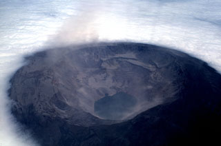
At 0500 on 30 March, Oswaldo Chapi and Fausto Cepeda (of the Galápagos National Park) heard noise from Fernandina Caldera, 22 km SW of their position at Tagus Cove. Glow was visible over the NW end of the caldera and a cloud was seen issuing from the same location after sunrise. The eruption was described as being smaller than the Volcán Wolf eruption of 1982.
On 1 and 2 April, the TOMS instrument in the NIMBUS 7 polar orbiting satellite detected SO2 produced by the eruption (figure 15-9). No data were available 30-31 March, and SO2 had dropped below the detection threshold by 3 April. Strongest values on 1 April were directly over the volcano and a preliminary estimate of total SO2 was 60,000 metric tons. No eruption cloud was evident on NOAA weather satellite imagery. On the afternoon of 4 April, the cruise ship Santa Cruz reported a long vapor plume coming from the caldera, but apparently decreasing in size. They looked for glow over the volcano that night but reported none.
On 11 April Fernandina was climbed from the NW by David Day [and others], who reported an apparently inactive lava flow reaching from the W side of the caldera (near the site of the major eruption of 1968) to the lake. At 0650 the next morning, [Day's group] heard a noise "like a large landslide" from their camp near the W caldera rim. Within 30 seconds, they reached the rim in time to see what Day described as a nuée ardente that had already moved from the vent area halfway to the lake. They left the rim, and observers from Punta Espinoza (17 km to the NE) described an eruptive cloud rising at 0655 to an estimated height of about 7 km. At 0704, [Day's group] was overtaken by an ash rain described as "raindrops with ash" and total darkness persisted until 0720. A thickness of 3 mm of tephra accumulated during that period at their rim camp. By 0725 it was clear enough to see into the caldera. Tephra covered the new lava on the caldera floor with the exception of an area a few hundred meters across in which molten lava could be seen. [The group] left the rim at 1030 and no further volcanism had been witnessed at the time of their radio report, at 1500 on 13 April, from Punta Espinoza. [A substantial part of the caldera wall collapsed into the 1984 vent area on 11 April, and was responsible for most, if not all, of the phenomena witnessed by Day and his group.]
This is the 6th known eruption of Fernandina since the major explosive eruption and massive caldera collapse of 1968. The last eruption was not recognized in the Galápagos, but its products are visible in an aerial photograph taken 26 March 1982. From a 900-m-long circumferential fissure on the S rim of the caldera, flows moved both inward (N) down the caldera wall and over a high topographic bench, and outward (S) where the flow ponded behind another row of circumferential vents. The eruption had not yet taken place when Tom Simkin and others passed this area on 4 December 1980.
Geological Summary. Fernandina, the most active of Galápagos volcanoes and the one closest to the Galápagos mantle plume, is a basaltic shield volcano with a deep 5 x 6.5 km summit caldera. The volcano displays the classic "overturned soup bowl" profile of Galápagos shield volcanoes. Its caldera is elongated in a NW-SE direction and formed during several episodes of collapse. Circumferential fissures surround the caldera and were instrumental in growth of the volcano. Reporting has been poor in this uninhabited western end of the archipelago, and even a 1981 eruption was not witnessed at the time. In 1968 the caldera floor dropped 350 m following a major explosive eruption. Subsequent eruptions, mostly from vents located on or near the caldera boundary faults, have produced lava flows inside the caldera as well as those in 1995 that reached the coast from a SW-flank vent. Collapse of a nearly 1 km3 section of the east caldera wall during an eruption in 1988 produced a debris-avalanche deposit that covered much of the caldera floor and absorbed the caldera lake.
Information Contacts: G. Reck, CDRS, Galápagos; L. Maldonado, Quito, Ecuador; D. Day, Isla Santa Cruz, Galápagos; A. Krueger, NASA/GSFC; M. Matson, NOAA/NESDIS.

