Report on Kilauea (United States) — April 1984

Scientific Event Alert Network Bulletin, vol. 9, no. 4 (April 1984)
Managing Editor: Lindsay McClelland.
Kilauea (United States) 18th episode; four lava flows, longest flow of 1983-84 eruption
Please cite this report as:
Global Volcanism Program, 1984. Report on Kilauea (United States) (McClelland, L., ed.). Scientific Event Alert Network Bulletin, 9:4. Smithsonian Institution. https://doi.org/10.5479/si.GVP.SEAN198404-332010
Kilauea
United States
19.421°N, 155.287°W; summit elev. 1222 m
All times are local (unless otherwise noted)
"After 19 days of repose, the eruption resumed at Pu'u O at approximately 1800 on 18 April. Following nearly 60 hours of continuous lava emission, vigorous lava production stopped at 0533 on 21 April. Episode 18 was the longest eruptive episode of 1984 on Kīlauea, and undoubtedly was one of the more voluminous of the 1983-84 series. About 200 x 106 m3 of basalt has been produced since the eruption began on 3 January 1983.
EPISODE 18
Eruption narrative. "After episode 17 ended on 31 March, the crater of Pu'u O was again a steep-walled, nearly flat-floored bowl about 50 m deep and 120 m across at the crater rim. As before, a nearly vertical 20-m-diameter pipe descended from near the center of the crater floor. Visibility down the pipe was obscured by fume in the days immediately following episode 17; exposed lava was first seen tens of meters down the pipe on 5 April. The lava surface, largely crusted much of the time, rose higher in the pipe over the following days; on 17 April, when last observed prior to episode 18, the crusted lava surface was less than 10 m below the top of the pipe.
"A time-lapse camera set at a 1-minute interval recorded the first low fountain activity within Pu'u O at 1751 on 18 April. At about 1800, lava was first recorded passing through the deep breach in the crater's NE rim. Intensity of activity increased, and by approximately 1900 the fountain crest was about 40 m above the surface of the lava pond within Pu'u O. Bad weather obscured visibility through much of the night, but frames exposed during brief clear periods suggest that the fountain was variable and at times was at least 200 m high. During the night, 10-20 cm of lapilli were deposited near Pu'u Kamoamoa (less than 1 km W of the vent), and Pele's hair fell at HVO, 20 km W of the vent. In the early morning the fountain height decreased, and for the rest of the eruption it was about 40-80 m above the pond. Major fountain activity and lava production stopped at 0533 on 21 April; emission of minor spatter continued for another hour.
"Episode 18 produced four major aa flows (figure 25), all fed by distributaries of the lava river that debouched vigorously and steadily through the breach in the NE crater wall. Three flows were active when the first observers arrived at 0700 on 19 April. Flows A and B were receiving the bulk of the lava, and their active fronts were 3 and 4 km from the vent. A small flow (C), extending SE along the Hawaii Volcanoes National Park boundary, was about 1.5 km long.
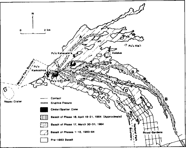 |
Figure 25. Kīlauea lava flow from episodes 17 and 18. Courtesy of HVO. |
"By 1800 on 19 April, flow A, 5 km long, had stopped, its supply cut off. Most of the lava was being channeled into flow B, which had become the main flow. It was about 8 km long and had advanced at an average rate of more than 300 m/hour to a point N of Royal Gardens subdivision. Flow C, along the park boundary, was about 3 km long and advancing slowly.
"During the night of 19-20 April, the rate of advance of the main flow (B) decreased, although the supply from the vent was apparently steady. By 0730 on 20 April, the flow front was advancing through the rain forest at the E edge of the episode 17 flow; the terminus was about 10 km from the vent. Flow C had advanced to about 4.5 km from the vent, and its distal end had stagnated. The relatively small volume of lava supplied to this flow over the next several hours ponded and spread laterally about 1.5 km SE of the vent.
"At 1730 on 20 April, when the day's last aerial reconnaissance was made, the main flow had extended nearly 14 km from the vent and was threatening three houses at the end of a road E of Royal Gardens. Supply to the flow along the park boundary had been completely cut off. However, just to the NE, a pahoehoe overflow from the main channel was about 1 km long and was extending SE. This was to become the 4th major flow (D) of episode 18.
"During the night of 20-21 April, the main flow slowly advanced more than 300 m and overran two of the three threatened houses before the eruption stopped at 0533. Creeping slowly after the eruption ended, the flow overran the 3rd house the following afternoon. This is the longest flow of the 18 eruptive episodes, extending more than 14 km to within just over a kilometer from the ocean.
"The 4th flow (D), which had originated as a pahoehoe overflow in the late afternoon of 20 April, apparently captured a greater part of the supply during the night. Advancing at an average rate of between 400 and 500 m/hour, it extended more than 7 km and entered the N part of the Royal Gardens subdivision. Observed in Royal Gardens in the early morning hours, it was thin and fluid, moving more like pahoehoe than like aa.
"The episode 18 basalt is similar to that of other recent episodes in hand-lens view and in lava temperature. Scattered small olivine phenocrysts comprise less than 1% of the rock, which is otherwise aphyric. The maximum temperature measured by thermocouple in pahoehoe was 1,144°C.
"At the eruption's end, debris from the crater walls plugged the opening of the pipe. However, by 23 April the pipe was once again open and vertical, and lava was seen deep (tens of meters) within it. Intermittent sightings of lava deep within the pipe have continued. Exact determinations of the depth to the lava are prevented by fume and by excessively hazardous access to the crater floor.
Seismicity and deformation. "Harmonic tremor, centered near Pu'u O, remained at a low level from 1-18 April. During this time, periods (up to several days long) of constant low amplitude alternated with periods of variable amplitude that fluctuated on a time scale of a few minutes to several hours. Starting from about 0245 on 18 April, 1-2-minute bursts of stronger tremor occurred at intervals of 15-30 minutes. By 1200, these bursts were longer, and eventually the activity became constant. Tremor amplitude increased sharply from 1810. At 1848 the seismic alarm was triggered, and shortly thereafter the tremor had increased to levels comparable to earlier major episodes of the eruption. High tremor was sustained throughout the period of vigorous eruption. At 0535 on 21 April, tremor decreased abruptly, following about 15 minutes of spasmodic decay in amplitude. The seismicity resumed its typical low interphase level characterized by fluctuating weak tremor and tiny shocks, associated with near surface events at Pu'u O. From 0520 to 0545 on 22 April, a flurry of seismic events resembling rockfall signatures, and increased tremor were recorded at Pu'u Kamoamoa seismograph. The episode may record collapse of the rubble that plugged the pipe inside Pu'u O. This burst of activity occurred about 3 hours after 2 S flank earthquakes centered about 10 km SW of Pu'u O: at 0223, magnitude 3.8, depth 10 km; and at 0226, magnitude 3.9, depth 8 km. Harmonic tremor continued at low level near Pu'u O through the remainder of the month.
"Summit subsidence during episode 18, measured in the E-W direction by the Uwekahuna tiltmeter, was between 19 and 20 µrad. This is the largest subsidence since episode 3, 28 March-9 April 1983. Again, onset of summit deflation and resumption of inflation as recorded by the tiltmeter followed slightly behind the beginning and end of lava emission."
Geological Summary. Kilauea overlaps the E flank of the massive Mauna Loa shield volcano in the island of Hawaii. Eruptions are prominent in Polynesian legends; written documentation since 1820 records frequent summit and flank lava flow eruptions interspersed with periods of long-term lava lake activity at Halemaumau crater in the summit caldera until 1924. The 3 x 5 km caldera was formed in several stages about 1,500 years ago and during the 18th century; eruptions have also originated from the lengthy East and Southwest rift zones, which extend to the ocean in both directions. About 90% of the surface of the basaltic shield volcano is formed of lava flows less than about 1,100 years old; 70% of the surface is younger than 600 years. The long-term eruption from the East rift zone between 1983 and 2018 produced lava flows covering more than 100 km2, destroyed hundreds of houses, and added new coastline.
Information Contacts: E. Wolfe, A. Okamura, and R. Koyanagi, HVO.