Report on Aira (Japan) — May 1984

Scientific Event Alert Network Bulletin, vol. 9, no. 5 (May 1984)
Managing Editor: Lindsay McClelland.
Aira (Japan) Explosive activity continues at high level; debris flows
Please cite this report as:
Global Volcanism Program, 1984. Report on Aira (Japan) (McClelland, L., ed.). Scientific Event Alert Network Bulletin, 9:5. Smithsonian Institution. https://doi.org/10.5479/si.GVP.SEAN198405-282080
Aira
Japan
31.5772°N, 130.6589°E; summit elev. 1117 m
All times are local (unless otherwise noted)
Explosive activity at the summit crater of Minami-dake continued at a higher level, January-April (figure 10). The average monthly number of recorded explosions was 27, including larger ones that caused damage.
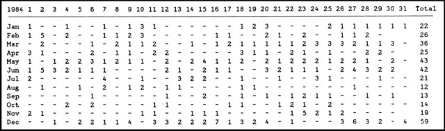 |
Figure 10. Summary table of explosions from Minami-dake crater at Sakura-jima, 1984. Data courtesy of JMA. |
Geological Summary. The Aira caldera in the northern half of Kagoshima Bay contains the post-caldera Sakurajima volcano, one of Japan's most active. Eruption of the voluminous Ito pyroclastic flow accompanied formation of the 17 x 23 km caldera about 22,000 years ago. The smaller Wakamiko caldera was formed during the early Holocene in the NE corner of the caldera, along with several post-caldera cones. The construction of Sakurajima began about 13,000 years ago on the southern rim and built an island that was joined to the Osumi Peninsula during the major explosive and effusive eruption of 1914. Activity at the Kitadake summit cone ended about 4,850 years ago, after which eruptions took place at Minamidake. Frequent eruptions since the 8th century have deposited ash on the city of Kagoshima, located across Kagoshima Bay only 8 km from the summit. The largest recorded eruption took place during 1471-76.
Information Contacts: JMA, Tokyo.