Report on Kaitoku Seamount (Japan) — May 1984

Scientific Event Alert Network Bulletin, vol. 9, no. 5 (May 1984)
Managing Editor: Lindsay McClelland.
Kaitoku Seamount (Japan) Discolored water; floating lapilli; formal name
Please cite this report as:
Global Volcanism Program, 1984. Report on Kaitoku Seamount (Japan) (McClelland, L., ed.). Scientific Event Alert Network Bulletin, 9:5. Smithsonian Institution. https://doi.org/10.5479/si.GVP.SEAN198405-284100
Kaitoku Seamount
Japan
26.1217°N, 141.0955°E; summit elev. -95 m
All times are local (unless otherwise noted)
JMSA observations beginning 7 March indicated that eruptive activity was at its highest level in mid to late March, when floating ejecta and vapor plumes were nearly always seen. Beginning in April, activity subsided gradually. The area of discolored water decreased from 13 x 30 km in early March to 300 m in diameter in early May (table 1).
On either side of the submarine vent are two shallow areas, at 26.13°N, 141.10°E, and 26.05°N, 140.93°E (figure 1). JMSA has formally named the feature Kaitoku Kaizan (Kaitoku Seamount).
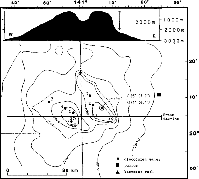 |
Figure 1. Cross-section (top) and bathymetry (bottom) at Kaitoku Seamount. Courtesy of JMSA. |
Geological Summary. Submarine eruption have been observed during March 1984 and August 2022-January 2023 from Kaitoku Seamount (Kaitoku Kaizan), a three-peaked submarine volcano 80 km NNW of Kita-Ioto. The type of activity related to other observations of discolored water or bubbling, including an observation from 1543 CE, is uncertain.
Information Contacts: JMA, Tokyo.