Report on Tinakula (Solomon Islands) — June 1984
Scientific Event Alert Network Bulletin, vol. 9, no. 6 (June 1984)
Managing Editor: Lindsay McClelland.
Tinakula (Solomon Islands) Tephra ejection; W flank submarine cone recognized
Please cite this report as:
Global Volcanism Program, 1984. Report on Tinakula (Solomon Islands) (McClelland, L., ed.). Scientific Event Alert Network Bulletin, 9:6. Smithsonian Institution. https://doi.org/10.5479/si.GVP.SEAN198406-256010
Tinakula
Solomon Islands
10.386°S, 165.804°E; summit elev. 796 m
All times are local (unless otherwise noted)
The following is from the cruise report of the USGS research vessel S.P. Lee, engaged in multichannel seismic profiling in the Vanuatu and Solomon Islands areas. The report was written by H.G. Greene, A. Macfarlane, and other members of the scientific party.
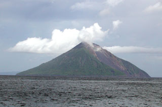
"On 3 June, Tinakula could be seen 'smoking' in the distance, some 25 km away. As the ship approached the island, large billowing clouds of steam were observed emanating from the summit of the volcano. Occasionally a large, billowing, dark gray, ash-laden plume was observed rising to several kilometers above the island without being disturbed by the prevailing SE trade winds, unlike the steam which was rapidly dissipated by those winds. The emanation of the ash appeared to take place at fairly regular intervals, about every 2 hours.
"The Lee passed within 400 m of Tinakula, on a W-E path along the N side of the island, which presented a good vantage point for observing the active vent at the head of the landslide scarp on the NW side of the volcano. As the ship drew abeam of Tinakula, rumbling sounds could be heard from within the active vent, immediately N of the central crater. Boulder-size (football-size) rocks were ejected from the vent, and were still steaming as they rolled and skipped down the steep, N-dipping scree slope and splashed into the sea. At least a dozen of the boulders and much more material of cobble size (65-250 mm in diameter) were seen being thrown from the vent every minute. Much of this debris was accumulating on the scree slope, which is actively infilling the void left by the 1971 landslide.
"Geophysical data collected by the Lee showed that another volcanic cone is present about 90 m beneath the surface of the water some 5 km W of Tinakula. This submarine volcano is a little smaller than Tinakula and in consequence not projecting above the sea surface. It has a very youthful geomorphic profile with sharp steep flanks, and appears from its morphology to be active. This volcano lies on the W flank of Tinakula and could be a vent associated with the same magmatic processes that are building the island today. This volcano or volcanic vent has not been identified before and is not on any bathymetric map."
Tinakula's last reported eruption started 6 September 1971, preceded by a small tsunami at the island. Intermittent explosive activity built a small summit cone, and incandescent blocks rolled down the volcano's flanks into the sea. A slow-moving lava flow extended about 300 m down the NW flank. About 160 people were evacuated from the island. The eruption ended in December 1971.
Geological Summary. The small 3.5-km-wide island of Tinakula is the exposed summit of a massive stratovolcano at the NW end of the Santa Cruz islands. It has a breached summit crater that extends from the summit to below sea level. Landslides enlarged this scarp in 1965, creating an embayment on the NW coast. The Mendana cone is located on the SE side. The dominantly andesitic volcano has frequently been observed in eruption since the era of Spanish exploration began in 1595. In about 1840, an explosive eruption apparently produced pyroclastic flows that swept all sides of the island, killing its inhabitants. Recorded eruptions have frequently originated from a cone constructed within the large breached crater. These have left the upper flanks and the steep apron of lava flows and volcaniclastic debris within the breach unvegetated.
Information Contacts: A. Macfarlane, Dept of Geology, Mines, and Rural Water Supplies, Vanuatu; H.G. Greene, USGS.

