Report on Mayon (Philippines) — August 1984
Scientific Event Alert Network Bulletin, vol. 9, no. 8 (August 1984)
Managing Editor: Lindsay McClelland.
Mayon (Philippines) Eruption clouds to 15 km; pyroclastic flows; lava flows
Please cite this report as:
Global Volcanism Program, 1984. Report on Mayon (Philippines) (McClelland, L., ed.). Scientific Event Alert Network Bulletin, 9:8. Smithsonian Institution. https://doi.org/10.5479/si.GVP.SEAN198408-273030
Mayon
Philippines
13.257°N, 123.685°E; summit elev. 2462 m
All times are local (unless otherwise noted)
Slow summit lava production started 10 September at 0821, after at least 12 hours of harmonic tremor [but eruptive activity started the previous evening (9:9)]. Activity was dominantly Strombolian 10-11 September. On the 10th, aerial observers reported that lava from the summit crater was slowly spilling over the rim. Incandescent blocks rolled 600 m down the NW flank, destroying or incinerating trees in their path. Ash-laden clouds rose several hundred meters above the summit. PHIVOLCS recommended the evacuation of people living in a danger zone within 8 km of the crater. The next day, ash-laden steam clouds were ejected to heights of as much as 3 km at intervals of 1-5 minutes. The strongest explosion, accompanied by loud detonations, began at about noon, producing a steam and ash column that rose 3 km and deposited as much as 2 cm of ash. Two lava flows about 200 m wide advanced at about 3 m per minute to about 2 km from the summit crater by evening.
Activity intensified and became more Vulcanian in character beginning on the 12th. Pyroclastic flows reached several kilometers from the summit. Nine explosions occurred within 3 hours starting around 1100, sending ash to 14.5 km altitude. The day's strongest explosion, at 1553, sent ash to nearly 15 km altitude. Incandescent tephra was evident in the eruption columns. Smaller explosions took place at 1-5-minute intervals. Sixteen additional "fairly strong" explosions occurred in a 17-hour period ending midmorning 13 September. Activity on the 13th was characterized by persistent ash emission to 3 km above the crater but no large eruption columns were observed. A total of 26 strong explosions ejecting incandescent tephra were recorded in a 12-hour period ending the morning of 14 September. Rain falling on nearby towns deposited 7.5 cm of wet ash. Three lava flows continued to advance down the NW, N, and SW flanks.
More than 16,000 people were evacuated from 36 villages, most of which were within the 8-km danger zone. Nine people were reported killed, eight by burial in volcanic debris and one by hot steam [but note that PHIVOLCS reported in 9:9 that no casualties were directly attributed to the eruption and mudflows].
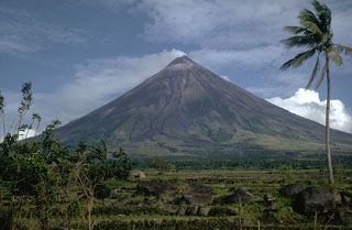
Geological Summary. Symmetrical Mayon, which rises above the Albay Gulf NW of Legazpi City, is the most active volcano of the Philippines. The steep upper slopes are capped by a small summit crater. Recorded eruptions since 1616 CE range from Strombolian to basaltic Plinian, with cyclical activity beginning with basaltic eruptions, followed by longer periods of andesitic lava flows. Eruptions occur predominately from the central conduit and have also produced lava flows that travel far down the flanks. Pyroclastic density currents and mudflows have commonly swept down many of the approximately 40 ravines that radiate from the summit and have often damaged populated lowland areas. A violent eruption in 1814 killed more than 1,200 people and devastated several towns.
Information Contacts: R. Punongbayan, PHIVOLCS, Quezon City; UPI; AP; DPA.

