Report on Kilauea (United States) — August 1984

Scientific Event Alert Network Bulletin, vol. 9, no. 8 (August 1984)
Managing Editor: Lindsay McClelland.
Kilauea (United States) Episode 24; high fountains; thin tephra blanket
Please cite this report as:
Global Volcanism Program, 1984. Report on Kilauea (United States) (McClelland, L., ed.). Scientific Event Alert Network Bulletin, 9:8. Smithsonian Institution. https://doi.org/10.5479/si.GVP.SEAN198408-332010
Kilauea
United States
19.421°N, 155.287°W; summit elev. 1222 m
All times are local (unless otherwise noted)
EPISODE 24
"The 24th eruptive episode of the 1983-84 eruption occurred on 19-20 August. Lava was first seen flowing through the vent's NE spillway at 2127 on 19 August. Vigorous fountaining began at 2210, reached a maximum height of 315 m above the spillway at about 0100 on 20 August, and ended at 1721. One major flow moved through the N spillway (the dominant path from the vent) and advanced N and NE, overriding much of the lava from episodes 22 and 23. The volume of lava produced was approximately 11.6 x 10⁶ m3. A thin, uniform, tephra blanket was deposited over much of the area within a radius of about 2 km.
"The Pu'u O summit height increased by about 3.5 m and had much the same form as in earlier episodes (see sketched profiles, figure 29). The total volume of tholeiitic basalt (not corrected for void space) produced since January 1983 is slightly more than 0.25 km3. The recent basalt, like that of earlier episodes, is nearly aphyric with widely scattered small (< 1 mm) phenocrysts of olivine.
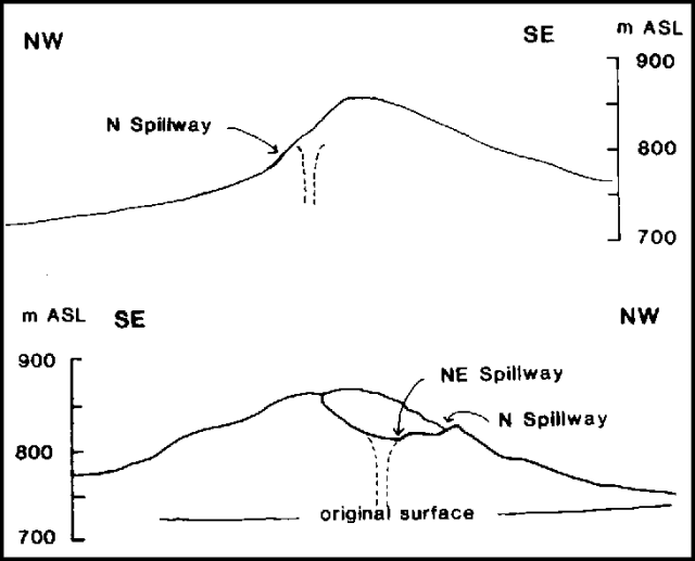 |
Figure 29. Profiles of Pu'u O cinder/spatter cone. No vertical exaggeration. Top, view to the SW showing location of the N and NE spillways following episode 23. Bottom, view to the NE during episode 24 showing the asymmetry of cone shape and the slope of the N spillway, which has become the dominant path of lava from the vent. |
Deformation. "During the 21-day repose prior to episode 24, the E-W summit tilt (measured at Uwekahuna bluff) increased by 10 µrad. Summit deflation, reflected by a downward tilt change of 14 µrad, began on 19 August at almost the same time as the onset of high fountaining and high-amplitude tremor at the eruption site. Deflation continued until 2000 on 20 August, about 2.5 hours after the end of lava production.
"Preliminary results from two horizontal deformation lines, installed across the E rift at points 0.7 and 9 km uprift from Pu'u O, show that changes since late June have been very small (< 20 mm), but systematic trends, similar on both lines, may be indicated. During the period of episodes 21-24, extension occurred on both sides of the rift axis between eruptive episodes and an almost equal contraction was measured following each episode. This cyclic extension and contraction suggests elastic behavior of the wall rock. Cumulative change in total line lengths has not occurred. The new telemetering tiltmeter installed near Makaopuhi Crater (about 6.5 km uprift from Pu'u O) has recorded no significant tilt changes since July.
Seismicity. "The Kamoamoa seismic station recorded continuous harmonic tremor through August. An increase in tremor amplitude near Pu'u O accompanied episode 24. A gradual buildup of high tremor started at 2125 on 19 August, 2 minutes before lava was first observed in the spillway; increased tremor continued throughout the episode and ended at 1721 the next day as fountaining stopped. Tremor of low to intermediate amplitude was also detected in the summit region. Low-level tremor with many sporadic bursts continued near Pu'u O for several days following the end of episode 24. The number of microearthquakes at the summit region fluctuated from low to average and was high in the E rift zone."
Geological Summary. Kilauea overlaps the E flank of the massive Mauna Loa shield volcano in the island of Hawaii. Eruptions are prominent in Polynesian legends; written documentation since 1820 records frequent summit and flank lava flow eruptions interspersed with periods of long-term lava lake activity at Halemaumau crater in the summit caldera until 1924. The 3 x 5 km caldera was formed in several stages about 1,500 years ago and during the 18th century; eruptions have also originated from the lengthy East and Southwest rift zones, which extend to the ocean in both directions. About 90% of the surface of the basaltic shield volcano is formed of lava flows less than about 1,100 years old; 70% of the surface is younger than 600 years. The long-term eruption from the East rift zone between 1983 and 2018 produced lava flows covering more than 100 km2, destroyed hundreds of houses, and added new coastline.
Information Contacts: G. Ulrich, A. Okamura, and R. Koyanagi, HVO.