Report on Unzendake (Japan) — September 1984

Scientific Event Alert Network Bulletin, vol. 9, no. 9 (September 1984)
Managing Editor: Lindsay McClelland.
Unzendake (Japan) Earthquake swarm
Please cite this report as:
Global Volcanism Program, 1984. Report on Unzendake (Japan) (McClelland, L., ed.). Scientific Event Alert Network Bulletin, 9:9. Smithsonian Institution. https://doi.org/10.5479/si.GVP.SEAN198409-282100
Unzendake
Japan
32.761°N, 130.299°E; summit elev. 1483 m
All times are local (unless otherwise noted)
Local seismic activity, which had increased since May, peaked in August when 6,370 seismic events, including 409 felt events, were recorded (figure 1). During the evening of 6 August the number of recorded earthquakes increased rapidly (table 1). Two large felt shocks and several minor felt shocks occurred within 10 minutes, causing 10 landslides and injuring two persons. Seismic activity has since declined, but remained above normal as of 26 September.
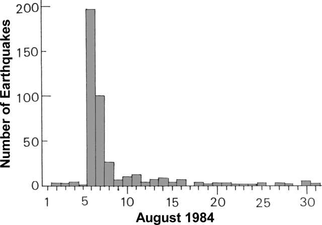 |
Figure 1. Daily number of felt earthquakes at Unzen Volcano, August 1984. Courtesy of JMA. |
Table 1. Earthquakes of M >= 4.0, 6 August 1984. Intensities are measured at the JMA Unzendake Weather Station, using the JMA scale (0-VII).
| Time | Magnitude | Depth of Focus | Intensity |
| 1728 | 4.8 | 6 km | IV |
| 1730 | 5.7 | 7 km | I |
| 1735 | 4.0 | 15 km | I |
| 1738 | 5.0 | 11 km | V |
| 1841 | 4.1 | 10 km | IV |
| 1949 | 4.0 | 8 km | IV |
Epicenters of the swarm, determined by the JMA seismic network, were concentrated on the W coast of Shimabara Peninsula about 8 km W of Fuken-dake, the most recently active peak of the Unzen Volcano Complex (figure 2). The depth of seismic sources deepened from E to W (figure 2, inset). The characteristic hypocenter distribution coincides with previous results from the University of Kyoto and JMA. Earthquake swarms without eruption have often occurred at Unzen.
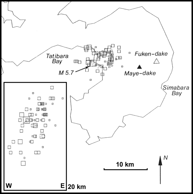 |
Figure 2. Map of Shimabara Peninsula. The Unzen Volcanic Complex occupies most of the peninsula. Fuken-dake (open triangle), Maye-dake (solid triangle) and epicenters of events, 6 August, 1300-7 August, 0325 (open squares) are shown. The E-W cross-section (inset) shows a depth range from the surface to 20 km. Courtesy of JMA. |
No eruptive activity has been observed since 1792, when explosions at Fuken-dake in February were followed by lava extrusion in March, and earthquakes and landslides in April and May. On 21 May an avalanche from Maye-dake (near the E coast), caused by an earthquake, created a major tsunami in Shimabara Bay that caused [15,000] fatalities and much destruction.
Further Reference. Sawada, Y., 1978, Seismic activity at Unzen-dake volcano and the unusual number of its occurrence and frequency: Papers in Meteorology & Geophysics, v. 29, p. 83-96.
Geological Summary. The massive Unzendake volcanic complex comprises much of the Shimabara Peninsula east of the city of Nagasaki. An E-W graben, 30-40 km long, extends across the peninsula. Three large stratovolcanoes with complex structures, Kinugasa on the north, Fugen-dake at the east-center, and Kusenbu on the south, form topographic highs on the broad peninsula. Fugendake and Mayuyama volcanoes in the east-central portion of the andesitic-to-dacitic volcanic complex have been active during the Holocene. The Mayuyama lava dome complex, located along the eastern coast west of Shimabara City, formed about 4000 years ago and was the source of a devastating 1792 CE debris avalanche and tsunami. Historical eruptive activity has been restricted to the summit and flanks of Fugendake. The latest activity during 1990-95 formed a lava dome at the summit, accompanied by pyroclastic flows that caused fatalities and damaged populated areas near Shimabara City.
Information Contacts: JMA, Tokyo; Kyodo News Service, Tokyo.