Report on Kilauea (United States) — September 1984

Scientific Event Alert Network Bulletin, vol. 9, no. 9 (September 1984)
Managing Editor: Lindsay McClelland.
Kilauea (United States) Episode 25; highest fountains of 1983-84 eruption; tephra
Please cite this report as:
Global Volcanism Program, 1984. Report on Kilauea (United States) (McClelland, L., ed.). Scientific Event Alert Network Bulletin, 9:9. Smithsonian Institution. https://doi.org/10.5479/si.GVP.SEAN198409-332010
Kilauea
United States
19.421°N, 155.287°W; summit elev. 1222 m
All times are local (unless otherwise noted)
EPISODE 25
"After a 30 day repose period, the 25th episode of the 1983-84 E rift zone eruption began at about 1604 on 19 September and ended at about 0532 the next day. Brief intervals of Strombolian activity and a small pahoehoe flow across the N spillway occurred over a 10-day period preceding episode 25. The largest flow exited through the N spillway and advanced on a broad front up to 3.3 km from Pu'u O (figure 30). A small, short-lived, fissure eruption occurred ENE of Pu'u O early in the episode, producing a thin pahoehoe flow about 800 m long just N of the National Park boundary. The total volume of lava produced was approximately 11.1 x 10⁶ m3. An unusually thick tephra mantle, estimated to have a volume of about 1 x 10⁶ m3, fell early in this episode, accompanying the highest (460 m) fountains yet observed in the 1983-84 eruption.
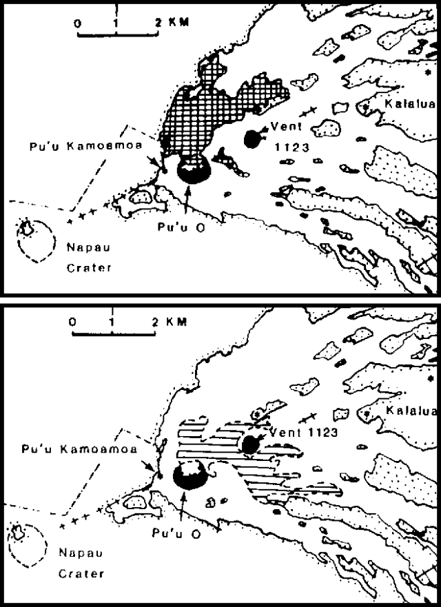 |
Figure 30. Lava flows erupted from Kīlauea between 3 January 1983 and 20 November 1984 on the E rift zone. Flows from episodes 25-27 are shown separately. Courtesy of HVO. |
"The summit of Pu'u O increased in height by 12 m during episode 25 and, within 11 days, had collapsed about 5 m, to stand 875 m above sea level and 155 m above the pre-1983 surface. The recent basalt, like that of earlier episodes, is nearly aphyric with widely scattered small (< 1 mm) phenocrysts of olivine.
Deformation. "During the 30-day repose period prior to episode 25, the E-W tilt recorded in the Uwekahuna vault increased by 17 µrad. Summit subsidence began around 1400 on 19 September. The net deflationary tilt change recorded during episode 25 was 15 µrad. Tiltmeters near the eruption site and at a site 6.5 km uprift recorded no significant tilt change during September. By the end of the month, slow reinflation of the summit was indicated by a recovery of 6 µrad.
Seismicity. "Prior to the onset of episode 25, tiny earthquakes, registered only at the Pu'u Kamoamoa station (about 500 m uprift from Pu'u O), started to increase after about 1500 on 19 September. At 1530, the level of harmonic tremor began to increase as well. Tremor increased rapidly at 1540, and was marked by a sharper increase at 1604. At 1613 the tremor alarm at HVO was triggered. At 1615, tremor amplitude peaked and remained at a high level until 0532 on 20 September. A rapid decrease in tremor was accompanied by intermittent high-amplitude bursts. For about 6 hours following the drop in tremor, there were many tiny high-frequency shocks recorded near Pu'u O.
"From about 2000 on 19 September to 0800 on 21 September, a swarm of very small long-period earthquakes combined with intermediate-amplitude harmonic tremor, apparently related to the post-deflation adjustments of the summit storage system, was recorded in the North Pit station at the summit.
"At the end of September, the level of tremor at Pu'u O was constant and very low in amplitude. The number of microearthquakes was low in the summit region and moderate in the E rift zone."
Geological Summary. Kilauea overlaps the E flank of the massive Mauna Loa shield volcano in the island of Hawaii. Eruptions are prominent in Polynesian legends; written documentation since 1820 records frequent summit and flank lava flow eruptions interspersed with periods of long-term lava lake activity at Halemaumau crater in the summit caldera until 1924. The 3 x 5 km caldera was formed in several stages about 1,500 years ago and during the 18th century; eruptions have also originated from the lengthy East and Southwest rift zones, which extend to the ocean in both directions. About 90% of the surface of the basaltic shield volcano is formed of lava flows less than about 1,100 years old; 70% of the surface is younger than 600 years. The long-term eruption from the East rift zone between 1983 and 2018 produced lava flows covering more than 100 km2, destroyed hundreds of houses, and added new coastline.
Information Contacts: G. Ulrich, A. Okamura, and R. Koyanagi, HVO.