Report on Krafla (Iceland) — October 1984

Scientific Event Alert Network Bulletin, vol. 9, no. 10 (October 1984)
Managing Editor: Lindsay McClelland.
Krafla (Iceland) Satellites detect SO2-rich plume from September eruption
Please cite this report as:
Global Volcanism Program, 1984. Report on Krafla (Iceland) (McClelland, L., ed.). Scientific Event Alert Network Bulletin, 9:10. Smithsonian Institution. https://doi.org/10.5479/si.GVP.SEAN198410-373080
Krafla
Iceland
65.715°N, 16.728°W; summit elev. 800 m
All times are local (unless otherwise noted)
The eruption continued in the northernmost part of the fissure system for nearly two weeks, before stopping on 18 September between 1600 and 1700. Inflation began again only a few hours after the end of the eruption.
Plumes from the eruption were detected by the NOAA 6 polar orbiting satellite and by the TOMS instrument on the Nimbus-7 polar orbiter. A NOAA 6 visible-band image [on] 5 September at 0841, about 9 hours after the eruption started, shows a plume extending about 180 km E from Krafla. From a point source, the plume broadened, reaching about 35 km width roughly 90 km from the volcano and remaining about that wide farther downwind.
The TOMS instrument detected large areas of SO2 enhancement at approximately local noon on 5, 6, and 7 September (figure 6). The plume extended ESE from the volcano on the 5th. Twenty four hours later, it was detected as a coherent body over Norway (roughly 1,300 km ESE of Krafla), and another 24 hours later over Estonia (roughly 2,200 km ESE of Krafla). NASA's preliminary estimate of the amount of SO2 in the plume is 35,000 metric tons. An SO2 ground monitor at Norrköping, Sweden (58°N, 16°E, about 1,900 km ESE of Krafla) detected a 40 milliatmosphere-cm anomaly on 7 September. The TOMS instrument detected smaller areas of SO2 enhancement on 10 September—again extending ESE from the vicinity of Krafla—and 18 September—NW of and detached from the volcano (figure 7). On other days between 4 and 19 September there were no SO2 enhancements detected by TOMS near Iceland.
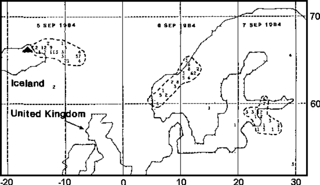 |
Figure 6. Preliminary SO2 data from the TOMS instrument on the Nimbus-7 polar orbiting satellite. The areas of enhanced SO2 values at local noon on 5, 6, and 7 September 1984 are outlined. Krafla is marked by a triangle. NW Europe is outlined. Each number represents the average SO2 value within an area 50 km across. Values above 9 are represented by A. B, etc. Courtesy of Arlin Krueger. |
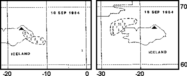 |
Figure 7. Areas of enhanced SO2 values detected in the vicinity of Iceland 10 and 18 September 1984 by the TOMS instrument on the Nimbus-7 satellite. Krafla is marked by a triangle. Each number represents the average SO2 value within an area 50 km across. Values above 9 are represented by A. B, etc. Courtesy of Arlin Krueger. |
Geological Summary. The Krafla volcanic system in the Northern Volcanic Zone (NVZ) of Iceland is about 100 km long, consisting of a fissure swarm and a central volcano with a 7 x 9 km caldera formed about 110,000 years ago that deposited a rhyolitic welded tuff. It has been moderately active in the Holocene, over three distinct eruptive periods; the current one has lasted about 2,800 years with six volcano-tectonic episodes, each with one or more basaltic fissure eruptions. Lava volumes (DRE) have been in the 0.1-1 km3 range. The Hverfjall and Ludent tuff rings east of Myvatn were erupted along the fissure system. Myvatn lake formed during the eruption of the older Laxarhraun lava flow from the Ketildyngja shield volcano of the Fremrinamur volcanic system about 3,800 years before present (BP); The present Myvatn lake is constrained by the roughly 2,000 years BP younger Laxarhraun lava flow from the Krafla volcanic system. The abundant pseudocraters that form a prominent part of the Myvatn landscape were created when the younger Laxarhraun lava flow entered the lake. The last eruption took place in 1975-1984 CE when nine small basaltic fissure eruptions produced 0.25 km3 of lava.
Information Contacts: A. Krueger, NASA/GSFC; M. Matson, NOAA/NESDIS; K. Grönvold, NVI.