Report on Veniaminof (United States) — December 1984
Scientific Event Alert Network Bulletin, vol. 9, no. 12 (December 1984)
Managing Editor: Lindsay McClelland.
Veniaminof (United States) Tremor accompanied November ash ejection; activity declines
Please cite this report as:
Global Volcanism Program, 1984. Report on Veniaminof (United States) (McClelland, L., ed.). Scientific Event Alert Network Bulletin, 9:12. Smithsonian Institution. https://doi.org/10.5479/si.GVP.SEAN198412-312070
Veniaminof
United States
56.17°N, 159.38°W; summit elev. 2507 m
All times are local (unless otherwise noted)
Weather clouds obscured the volcano from mid-December through early January. A pilot who flew over the volcano on 2 January observed no activity.
The following is from John Taber and Ken Hudnut. "The most recent eruptive activity at Veniaminof had little associated seismicity as compared to the previous eruption. During the recent activity a Lamont-Doherty seismic monitoring station 30 km from the caldera recorded only small amounts of tremor, which lasted a total of about 20 minutes. Only 4 events of 1-2 minutes duration were recorded in the 5 days before the observed eruption. Seismic activity increased at 0420 on 29 November with 8 minutes of tremor roughly corresponding to first reports of rumbling noises by Perryville residents. Fourteen low-frequency events, possibly tremor, were recorded during the first 5 hours of the eruption, then recorded seismicity decreased. There is no notable correlation of timing of these seismic events with observations of eruptive activity."
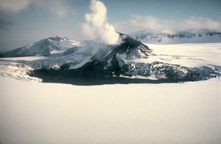
Geological Summary. Veniaminof, on the Alaska Peninsula, is truncated by a steep-walled, 8 x 11 km, glacier-filled caldera that formed around 3,700 years ago. The caldera rim is up to 520 m high on the north, is deeply notched on the west by Cone Glacier, and is covered by an ice sheet on the south. Post-caldera vents are located along a NW-SE zone bisecting the caldera that extends 55 km from near the Bering Sea coast, across the caldera, and down the Pacific flank. Historical eruptions probably all originated from the westernmost and most prominent of two intra-caldera cones, which rises about 300 m above the surrounding icefield. The other cone is larger, and has a summit crater or caldera that may reach 2.5 km in diameter, but is more subdued and barely rises above the glacier surface.
Information Contacts: M. E. Yount, USGS, Anchorage; J. Taber and K. Hudnut, LDGO.

