Report on Kama'ehuakanaloa (United States) — January 1985
Scientific Event Alert Network Bulletin, vol. 10, no. 1 (January 1985)
Managing Editor: Lindsay McClelland.
Kama'ehuakanaloa (United States) Increased seismicity; nine events of magnitude 3 or greater
Please cite this report as:
Global Volcanism Program, 1985. Report on Kama'ehuakanaloa (United States) (McClelland, L., ed.). Scientific Event Alert Network Bulletin, 10:1. Smithsonian Institution. https://doi.org/10.5479/si.GVP.SEAN198501-332000
Kama'ehuakanaloa
United States
18.92°N, 155.27°W; summit elev. -975 m
All times are local (unless otherwise noted)
"Since November 1984, a renewed increase in earthquakes in the Lōʻihi region has been recorded on the HVO seismic network. The recent activity occurred episodically in three minor bursts on 11 November and 10 and 21 January. From November 1984 to January 1985, 19 earthquakes of magnitude 2.0 or greater occurred in the Lōʻihi region (figure 1). Nine of the larger events ranged in magnitude from 3.0 to 4.2.
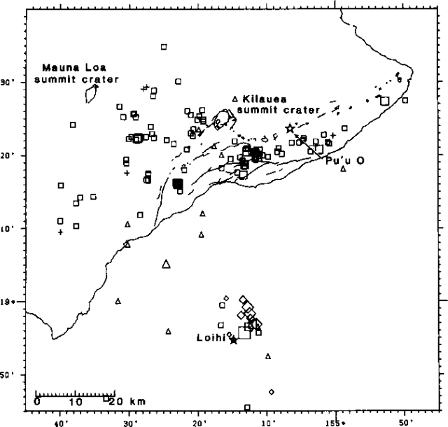 |
Figure 1. Plot of earthquakes of M >= 2 in the Hawaii region, November 1984-January 1985. Squares indicate events with depths of 5-13 km, diamonds 13-20 km, and triangles > 20 km. Symbols of different sizes show the relative magnitudes of events; the largest event near Lōʻihi was M 4.2. |
"Although the current activity is relatively minor, swarm earthquakes characteristically associated with magmatic movement and volcanism in Hawaii have been known to gradually develop from such episodic increases. Significant earthquake swarms inferring magmatic activity at Lōʻihi were detected in 1971-72 and 1975. The recurring episodes of earthquake swarms suggesting development of volcanism S of Hawaii are consistent with the pattern of progressive southeastward growth of the Hawaiian Islands in the context of plate tectonics and volcanism in the mid-Pacific region."
The nearest seismic station is about 30 km from Lōʻihi on the S coast of the island of Hawaii. Seismic events at Lōʻihi smaller than magnitude 2 may be recorded by stations on Hawaii, but their locations cannot be determined as precisely as for larger events.
Geological Summary. The Kama’ehuakanaloa seamount, previously known as Loihi, lies about 35 km off the SE coast of the island of Hawaii. This youngest volcano of the Hawaiian chain has an elongated morphology dominated by two curving rift zones extending north and south of the summit. The summit region contains a caldera about 3 x 4 km and exhibits numerous lava cones, the highest of which is about 975 m below the ocean surface. The summit platform also includes two well-defined pit craters, sediment-free glassy lava, and low-temperature hydrothermal venting. An arcuate chain of small cones on the western edge of the summit extends north and south of the pit craters and merges into the crests prominent rift zones. Seismicity indicates a magmatic system distinct from that of Kilauea. During 1996 a new pit crater formed at the summit, and lava flows were erupted. Continued volcanism is expected to eventually build a new island; time estimates for the summit to reach the ocean surface range from roughly 10,000 to 100,000 years.
Information Contacts: R. Koyanagi and W. Tanigawa, USGS Hawaiian Volcano Observatory.