Report on Kilauea (United States) — January 1985

Scientific Event Alert Network Bulletin, vol. 10, no. 1 (January 1985)
Managing Editor: Lindsay McClelland.
Kilauea (United States) Episodes 29-30; fountains to 460 m; heavy tephra fall
Please cite this report as:
Global Volcanism Program, 1985. Report on Kilauea (United States) (McClelland, L., ed.). Scientific Event Alert Network Bulletin, 10:1. Smithsonian Institution. https://doi.org/10.5479/si.GVP.SEAN198501-332010
Kilauea
United States
19.421°N, 155.287°W; summit elev. 1222 m
All times are local (unless otherwise noted)
EPISODE 29
"The E rift zone of Kīlauea entered its 3rd year of repeated eruptive activity with its 29th major display of high fountaining and vigorous lava production beginning at 1315 on 3 January, exactly 2 years after the first eruption in 1983. This episode followed 29 days when the magma column was frequently visible within the upper 40 m of the 25 m-diameter conduit of Pu'u O. It was also preceded by two small events of fountaining 3-10 m high and pahoehoe spillovers from the Pu'u O conduit on 30 December and 2 January.
"Fountains briefly reached a maximum height of 460 m about 3 hours after episode 29 began, matching the previous record set early in episode 25. Very heavy tephra fall (estimated volume [0.15] x 106 m3) occurred on the SE side of Pu'u O and the cone height increased by 14 m, but about 8 m were lost by collapse during the next 2 weeks, after which Pu'u O's summit was about 195 m above the pre-1983 surface. A broad aa flow traveled 4 km S (figure 32), burying much of the episode 28 flow and terminating about 1.7 km from Royal Gardens subdivision. Episode 29 ended abruptly at 0504 on 4 January. The total production of new lava was about 13 x 106 m3. The recent basalt, like that of earlier episodes, is nearly aphyric with widely scattered small (< 1 mm) olivine phenocrysts.
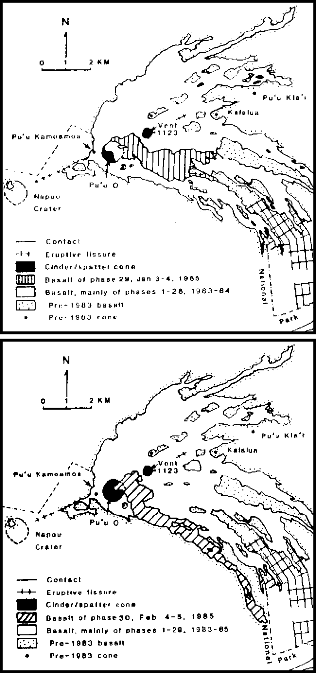 |
Figure 32. Lava flows erupted from Kīlauea between 3 January 1983 and 5 February 1985 on the E rift zone. Flows from episode 29 (top) and episode 30 (bottom), are shown separately. Courtesy of HVO. |
Deformation. "The summit subsided rapidly during episode 29. The Uwekahuna (W-E) tiltmeter recorded subsidence from approximately 1100 on 3 January to 0800 on 4 January. The most rapid deflation recorded was between 1600 and 1800 on the 3rd and reached a value of nearly 1.3 µrad/hour (figure 33). The net tilt change during episode 29 was 16 µrad. The summit had recovered approximately 13 µrad of inflationary tilt by the end of January.
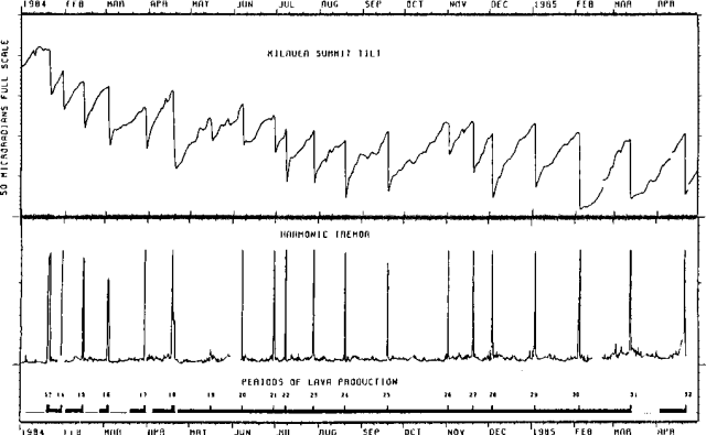 |
Figure 33. Kīlauea summit tilt, relative amplitude of harmonic tremor at the Pu'u Kamoamoa seismic station, and periods of lava production for 1984-85. In the lower plot, showing lava production, tall bars represent periods of high fountaining and vigorous flow production; short bars represent periods of low-level activity including magma frequently visible in the conduit. The gap in the tremor record following episode 30 is a result of the relocation of the Pu'u Kamoamoa seismic station. Courtesy of HVO. |
Seismicity. "On 2 January between 1500 and 1950, a slight increase in tremor amplitude was recorded near Pu'u O. The seismic level decreased and remained relatively low until the following day at about 1100 (2 hours and 15 minutes before the eruption began), when the amplitude of continuous tremor began to increase gradually. A rapid increase of tremor associated with the high fountaining of episode 29 started about 1340. Tremor amplitude remained strong throughout the eruptive episode. Tremor decreased sharply at 0504 on 4 January, at the end of major lava production.
"Seismicity then decreased to the normal background activity in the Kīlauea region. Harmonic tremor in the middle E rift zone remained low, varying from relatively constant amplitude to periodic fluctuations in amplitude that were commonly correlated with gas-pistoning activity at the vent. Shallow microearthquakes were few in the summit region and varied from few to moderate in number in the E rift zone."
Addendum: At 0546 on 4 February, episode 30 began. Vigorous fountaining fed a major lava flow that extended 7 km SE from Pu'u O, before eruptive activity ended at about 0246 on the 5th.
Geological Summary. Kilauea overlaps the E flank of the massive Mauna Loa shield volcano in the island of Hawaii. Eruptions are prominent in Polynesian legends; written documentation since 1820 records frequent summit and flank lava flow eruptions interspersed with periods of long-term lava lake activity at Halemaumau crater in the summit caldera until 1924. The 3 x 5 km caldera was formed in several stages about 1,500 years ago and during the 18th century; eruptions have also originated from the lengthy East and Southwest rift zones, which extend to the ocean in both directions. About 90% of the surface of the basaltic shield volcano is formed of lava flows less than about 1,100 years old; 70% of the surface is younger than 600 years. The long-term eruption from the East rift zone between 1983 and 2018 produced lava flows covering more than 100 km2, destroyed hundreds of houses, and added new coastline.
Information Contacts: G. Ulrich, R. Koyanagi, R. Hanatani, HVO.