Report on Kilauea (United States) — February 1985

Scientific Event Alert Network Bulletin, vol. 10, no. 2 (February 1985)
Managing Editor: Lindsay McClelland.
Kilauea (United States) 30th episode lasts about 21 hours; tephra falls in Hilo
Please cite this report as:
Global Volcanism Program, 1985. Report on Kilauea (United States) (McClelland, L., ed.). Scientific Event Alert Network Bulletin, 10:2. Smithsonian Institution. https://doi.org/10.5479/si.GVP.SEAN198502-332010
Kilauea
United States
19.421°N, 155.287°W; summit elev. 1222 m
All times are local (unless otherwise noted)
EPISODE 30
"Episode 30 began on 4 February at 0546. High fountains and continuous lava production from the Pu'u O vent continued for 21 hours until 0246 on 5 February. Lava flows spilled over the NE rim of the cone and turned S to form one 8.3 km-long aa flow (figure 32). The flow advanced rapidly through National Park forest and passed 0.7 km W of Royal Gardens subdivision. Nearly 2 km2 of forest were destroyed by the lava flow, and grass fires at the distal end of the lava burned an additional 0.3 km2 over the next 3 days. SW winds deposited tephra and Pele's hair in Hilo, 35 km from the vent.
"Episode 30 produced about 14 x 106 m3 of lava and a minimum of 0.09 x 10⁶ m3 of tephra (dense rock equivalent). Dense basalt specimens from the episode 30 flow appear to contain a higher concentration of olivine microphenocrysts than those of previous episodes.
"Because of the unusual wind direction during episode 30, the elevation of Pu'u O's summit increased by only a meter to 913 m above sea level. The growth of the cone since episode 24, as seen from a photo station on vent 1123, is illustrated in figure 34.
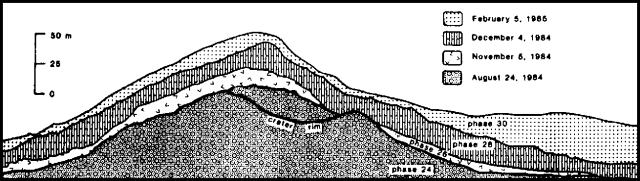 |
Figure 34. Profiles of Pu'u O as seen froma photo station on vent 1123, 1,500 m to the NE, after episodes 24, 26, 28, and 30. Courtesy of HVO. |
"Pu'u O was in repose for the remainder of February, although the magma column was intermittently visible at an estimated depth of 40-50 m in the 20 m-wide conduit.
Deformation. "Rapid summit subsidence associated with episode 30 began on 4 February at 0600, about ¼ hour after the onset of lava fountaining. The Uwekahuna (W-E) tiltmeter recorded continuous summit deflation until 0400 on 5 February, about 75 minutes after vigorous lava production ended. The maximum deflation rate was 1.75 µrad/hour, the highest rate recorded since the initial episode of intrusion and eruption in January 1983. The net tilt change was -22 µrad. Reinflation began very slowly, but by the end of February, the summit tilt had recovered 10.4 µrad.
Seismicity. "Harmonic tremor recorded at the Kamoamoa seismic station near Pu'u O began to increase 4 February at 0552, a few minutes after lava emission began. After 0600, tremor increased rapidly to a high amplitude that was sustained until the early morning hours of 5 February, when the tremor level began to fluctuate. Tremor amplitude dropped to the characteristic inter-episode signal at 0247 as episode 30 ended. For the remainder of the month, harmonic tremor continued at variable low amplitudes in the middle E rift zone.
"Seismic activity was highlighted by a magnitude 4.9 earthquake 9 km beneath the S flank on 21 February at 1948. The event was widely felt on the island and was followed by a series of aftershocks, but the earthquake had no immediate effect on the pattern of summit tilt or inter-episode activity at Pu'u O.
"Preliminary geodetic measurements near the epicenter of the 21 February earthquake showed that surface deformation was relatively local and did not extend beyond 4 km from the epicenter. Similarly, measurements made across the E rift zone at Pu'u O and near Mauna Ulu 4 days after the earthquake showed no significant deformation.
Addendum: On 13 March at 0720, episode 31 began. Lava fountaining fed flows that extended about 6 km SE from Pu'u O; lava flows entered Royal Gardens subdivision, but no structures were damaged. The 21-hour episode ended about 0455 on the 14th.
Geological Summary. Kilauea overlaps the E flank of the massive Mauna Loa shield volcano in the island of Hawaii. Eruptions are prominent in Polynesian legends; written documentation since 1820 records frequent summit and flank lava flow eruptions interspersed with periods of long-term lava lake activity at Halemaumau crater in the summit caldera until 1924. The 3 x 5 km caldera was formed in several stages about 1,500 years ago and during the 18th century; eruptions have also originated from the lengthy East and Southwest rift zones, which extend to the ocean in both directions. About 90% of the surface of the basaltic shield volcano is formed of lava flows less than about 1,100 years old; 70% of the surface is younger than 600 years. The long-term eruption from the East rift zone between 1983 and 2018 produced lava flows covering more than 100 km2, destroyed hundreds of houses, and added new coastline.
Information Contacts: C. Heliker, R. Hanatani, R. Koyanagi, HVO.