Report on Rabaul (Papua New Guinea) — March 1985

Scientific Event Alert Network Bulletin, vol. 10, no. 3 (March 1985)
Managing Editor: Lindsay McClelland.
Rabaul (Papua New Guinea) Moderate seismic and deformation crisis after several months of decreased activity
Please cite this report as:
Global Volcanism Program, 1985. Report on Rabaul (Papua New Guinea) (McClelland, L., ed.). Scientific Event Alert Network Bulletin, 10:3. Smithsonian Institution. https://doi.org/10.5479/si.GVP.SEAN198503-252140
Rabaul
Papua New Guinea
4.2459°S, 152.1937°E; summit elev. 688 m
All times are local (unless otherwise noted)
"After about 4 1/2 months of relatively low activity, a moderate seismic and deformation crisis took place in Rabaul Caldera on 3 March. The part of the caldera affected was the region between Davapia Rocks and Rabalanakaia Volcano (figure 6). The strongest earthquake was an ML 3.6 event; altogether there were six earthquakes of M 3 or greater. More than 600 small earthquakes were also detected, most less than 2 km deep. Associated measured ground deformation was mild; the largest tilt change was 16 µrad at the NW shore of Greet Harbour, and no significant changes were noted in EDM lines across the affected area.
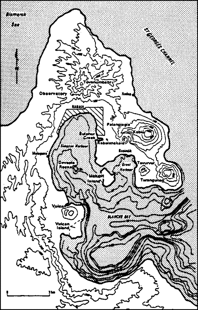 |
Figure 6. Topography and bathymetry of Rabaul Caldera, including intracaldera and satellite cones. Contours on land are in meters and isobaths are in fathoms, at about 37 m intervals. After McKee and others, 1983. |
"Apart from the crisis, activity was at low levels in March. The total number of earthquakes for the month (including the crisis of the 3rd) was 2,052, and the average background number of events was 45 per day. The seismic energy output was about [6.9 x 10¹⁶] ergs, most released during the crisis. The Matupit Island-Greet Harbour area continued to be the focus of ground deformation, with the largest tilts about 30 µrad at Sulphur Point. Levelling carried out 11-18 March indicated that since the previous survey (21-29 January) greatest uplift (45 mm) had taken place at the S end of Matupit Island. Maximum rates of horizontal deformation continued to be about 10 ppm per month."
Reference. McKee, C., and others, 1983, Rabaul Caldera, Papua New Guinea: Volcanic hazards and eruption contingency planning: Geological Survey of Papua New Guinea Report 83/17, 38 p.
Geological Summary. The low-lying Rabaul caldera on the tip of the Gazelle Peninsula at the NE end of New Britain forms a broad sheltered harbor utilized by what was the island's largest city prior to a major eruption in 1994. The outer flanks of the asymmetrical shield volcano are formed by thick pyroclastic-flow deposits. The 8 x 14 km caldera is widely breached on the east, where its floor is flooded by Blanche Bay and was formed about 1,400 years ago. An earlier caldera-forming eruption about 7,100 years ago is thought to have originated from Tavui caldera, offshore to the north. Three small stratovolcanoes lie outside the N and NE caldera rims. Post-caldera eruptions built basaltic-to-dacitic pyroclastic cones on the caldera floor near the NE and W caldera walls. Several of these, including Vulcan cone, which was formed during a large eruption in 1878, have produced major explosive activity during historical time. A powerful explosive eruption in 1994 occurred simultaneously from Vulcan and Tavurvur volcanoes and forced the temporary abandonment of Rabaul city.
Information Contacts: C. McKee, RVO.