Report on Sangeang Api (Indonesia) — September 1985

Scientific Event Alert Network Bulletin, vol. 10, no. 9 (September 1985)
Managing Editor: Lindsay McClelland.
Sangeang Api (Indonesia) 30 July eruption plume seen on satellite images
Please cite this report as:
Global Volcanism Program, 1985. Report on Sangeang Api (Indonesia) (McClelland, L., ed.). Scientific Event Alert Network Bulletin, 10:9. Smithsonian Institution. https://doi.org/10.5479/si.GVP.SEAN198509-264050
Sangeang Api
Indonesia
8.2°S, 119.07°E; summit elev. 1912 m
All times are local (unless otherwise noted)
GMS images showed plumes from the initial 30 July activity (figure 1). Digital data analyses of temperatures at the tops of the plumes compared with radiosonde altitude profiles suggested that they reached a maximum altitude of 14.1 km (table 1), below the tropopause. However, Yosihiro Sawada notes that for both this and other eruptions, altitudes calculated with this technique seem to be consistently higher than estimates from ground observers.
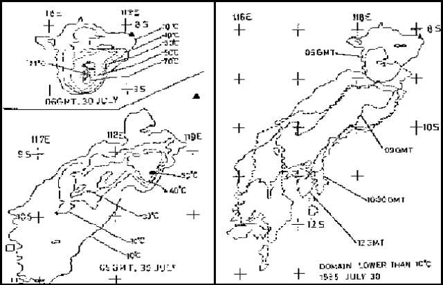 |
Figure 1. Surface temperatures (in °C) of eruption clouds from Sangeang Api (left), 30 July 1985, 1400 (top) and 1700 (bottom) Zones of plume surface from Sangeang Api (right) with temperatures less than 10°C on 30 July at 1400, 1700, 1830, and 2000. Courtesy of Yosihiro Sawada. |
Table 1. Sangeang Api eruption cloud data from GMS satellite images on 30 July 1985. Maximum altitude of the eruption cloud is estimated by comparing the GMS digital temperature data with temperature/altitude data profiles from nearby radiosondes. No plume was evident on the image returned at 1100. A plume could be detected from 30 July at 1400 until 31 July at 0200, but none was visible 3 hours later. Maximum plume extent was reached at 1900.
| Date | Time | Length (km) | Width (km) | Min Temp | Max Alt (km) | Remarks |
| 30 Jul 1985 | 1400 | 135 | 105 | -71°C | 14.1 | emerging from volcano |
| 30 Jul 1985 | 1700 | 315 | 100 | -50°C | 11.8 | detached from volcano |
| 30 Jul 1985 | 1800 | 385 | 150 | -37°C | 10.2 | detached from volcano |
| 30 Jul 1985 | 1830 | 405 | 160 | -30°C | 9.4 | detached from volcano |
| 30 Jul 1985 | 1900 | 425 | 130 | -24°C | 8.5 | detached from volcano |
Geological Summary. Sangeang Api volcano, one of the most active in the Lesser Sunda Islands, forms a small 13-km-wide island off the NE coast of Sumbawa Island. Two large trachybasaltic-to-tranchyandesitic volcanic cones, Doro Api and Doro Mantoi, were constructed in the center and on the eastern rim, respectively, of an older, largely obscured caldera. Flank vents occur on the south side of Doro Mantoi and near the northern coast. Intermittent eruptions have been recorded since 1512, most of them during in the 20th century.
Information Contacts: Y. Sawada, MRI, Tsukuba.