Report on Guallatiri (Chile) — November 1985
Scientific Event Alert Network Bulletin, vol. 10, no. 11 (November 1985)
Managing Editor: Lindsay McClelland.
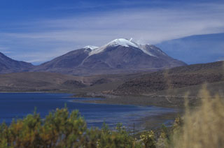
Guallatiri (Chile) Vapor plumes at 1-minute intervals
Please cite this report as:
Global Volcanism Program, 1985. Report on Guallatiri (Chile) (McClelland, L., ed.). Scientific Event Alert Network Bulletin, 10:11. Smithsonian Institution. https://doi.org/10.5479/si.GVP.SEAN198511-355020
Guallatiri
Chile
18.42°S, 69.092°W; summit elev. 6071 m
All times are local (unless otherwise noted)
[This activity was initially attributed to Acotango in the Quimsachata Volcano Group. It is now thought to have originated from Guallatiri, further along the same line of sight as Acotango (figure 1). Investigation of Acotango volcano in 1987, by Oscar González-Ferrán, revealed no evidence of a recent eruption.]
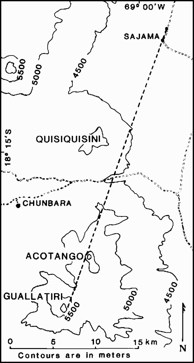 |
Figure 1. Sketch map of the Nevados de Quimsachata area. Volcano names are in large type, town names in smaller type. Roads are indicated by pairs of dashed lines. Contour interval is 500 m. Robert Koeppen's line of sight fro his observation point near Sajama, Bolivia, is shown by a dashed line. The border between Chile and Bolivia is not shown, but follows the crest of the Andes. Courtesy of Robert Koeppen, USGS. |
The quoted material is a report from Robert Koeppen. "On 1 December at 0750, Robert Koeppen (USGS), Walter West (U. S. Embassy, La Paz, Bolivia), and Jaime Jauregui (Geological Survey of Bolivia) observed steam plumes erupting from a source near the crest of Nevados de Quimsachata. The observation was made from a point about 25 km to the NNE, near the W base of Volcán Nevado Sajama, Bolivia. Visibility was initially excellent, but within about 45 minutes cloud cover completely obscured the mountain's summit. Intervening peaks prevented exact determination of the vent, but the eruption appeared to originate from Cerro Acotango, either from the main summit or possibly immediately to the NW. If the eruption plume came from Volcán Guallatiri, the next possible source area along the line of sight, then it would represent a significantly larger eruption (figure 1).
"The eruptions produced white, billowing clouds that rose vertically above the Quimsachata crest, perhaps about 500 m, then drifted W. The eruptions occurred in episodic bursts, and, based on first sightings of the plumes, at intervals ranging from 45-75 seconds. One large plume drifted more NW and appeared to trail a curtain, possibly of ash fallout. Several bursts seemed particularly vigorous and appeared to consist of several plumes coalescing at higher levels."
Chilean forest service personnel based near Lago Chungara, roughly 20 km to the NW, reported that they had seen no activity, but visibilities in the area are frequently poor.
No eruptions are known in historic time from Cerro Acotango, but Yoshio Katsui and Oscar González-Ferrán (1968) mapped it as Holocene. Four historic eruptions bave been reported from Guallatiri, most recently in December 1960. Chilean geologists note that fumarolic activity from Guallatiri is apparently continuous but less vigorous than the plume emission observed 1 December.
Reference. Katsui, Y., and González-Ferrán, O., 1968, Geología del area neovolcánica de los Nevados de Payachata: Publicaciones del Instituto de Geología, Universidad de Chile, no. 29, 161 p.
Geological Summary. One of northern Chile's most active volcanoes, Volcán Guallatiri is a symmetrical ice-clad stratovolcano at the SW end of the Nevados de Quimsachata volcano group. It lies just W of the border with Bolivia and is capped by a central dacitic dome or lava complex, with the active vent situated on its S side. Thick lava flows are prominent on the lower N and W flanks of the andesitic-to-rhyolitic volcano. Minor explosive eruptions have been reported since the beginning of the 19th century. Intense fumarolic activity with "jet-like" noises continues, and numerous solfataras extend more than 300 m down the W flank.
Information Contacts: R. Koeppen, USGS, Reston, VA; L. López E., Univ. de Chile, Santiago.