Report on Etna (Italy) — December 1985
Scientific Event Alert Network Bulletin, vol. 10, no. 12 (December 1985)
Managing Editor: Lindsay McClelland.
Etna (Italy) SE-flank fissure eruption follows seismic swarm and deformation
Please cite this report as:
Global Volcanism Program, 1985. Report on Etna (Italy) (McClelland, L., ed.). Scientific Event Alert Network Bulletin, 10:12. Smithsonian Institution. https://doi.org/10.5479/si.GVP.SEAN198512-211060
Etna
Italy
37.748°N, 14.999°E; summit elev. 3357 m
All times are local (unless otherwise noted)
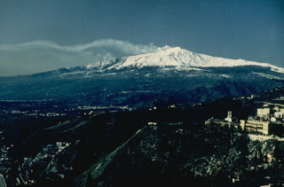
Eruptive activity. (Romolo Romano) "Strombolian activity started from the Southeast Crater on 19 December. The activity occurred at irregular intervals, becoming increasingly intense and continuous in successive days. Since the end of the 12 March-13 July 1985 eruption, more or less intense strombolian activity had been observed from several explosive vents (variable in number and position) on the floor of Bocca Nuova at variable depths (from 100 to 300 m or more from the rim of the vent).
"On 25 December at 0340 an eruptive fissure opened on the W side of the Valle del Bove (on Etna's SE flank), beginning at 2,750 m above sea level. The opening of this E-W-oriented fissure was preceded by a seismic crisis (see below). Strombolian activity soon started along this fissure from at least three explosive vents, while a lava flow began from the lower end of the fissure, covering, in a period of 18 hours, a distance of 1.5 km. The lava flow stopped at a point NE of Monte Centenari, at about 1,700 m elevation, within the Valle del Bove. Eruptive activity from the fissure stopped early the next morning. Activity resumed from the same place early 28 December. This second eruptive phase was characterized by weak strombolian activity from the three explosive vents, and created small spatter cones. The effusive activity decreased; a very viscous lava flow moved ~300 m from the origin, branching at ~2,600 m elevation. The eruptive phase ceased during the early morning of 31 December. A violent expulsion of ash and lapilli from the summit craters (E and W vents of the central crater, Southeast Crater, and Northeast Crater) during the first hours of the eruption was succeeded by more or less continuous and consistent emission of reddish ash.
"The Etna Guides (S. Carbonaro, O. Consoli, A. Mazzaglia, A. Nicotizza, and volunteers of the Alpine Rescue Team of the Italian Alpine Club (A. Cristaudo) have collaborated in collecting information about the eruptive activity.
Seismic activity. (M. Cosentino, M. DiFrancesco, and E. Lombardo) "A seismic crisis began during the early morning of 25 December with shocks located mainly between Piano Provenzana (NE flank) and the Valle del Bove. The shocks were very shallow (2 km or less). At the same time, the amplitude of harmonic tremor increased sharply. The shock that destroyed the hotel Le Betulle at Piano Provenzana, killing one person and injuring seven others, occurred on 25 December at 0338 and had a magnitude of 3.5. During the following 48 hours, about 200 more tremors with magnitudes of 1-4 were recorded. The strongest, M 4, occurred on 26 December at 0334, with its epicenter at Piano Provenzana. Focal depths were 2-3 km. The area of the epicenters remained between Piano Provenzana and Valle del Bove. Beginning 27 December, seismicity decreased in frequency, energy, and number of events, and stabilized to values of ~5-6 shocks/day. Their location was mainly in the eruptive area and on the E and W flanks (especially in early January). Similar activity was continuing on 10 January."
Newspapers reported that continuing seismicity included an event on 12 January at 0037, centered in the Zafferana Etnea area (11 km SE of the summit), that reached MM 6 and damaged some buildings. At least 3-4 minor shocks (one of MM 3) were felt the previous day.
Ground deformation. (G. Nunnari and R. Velardita) "During the second half of December, the tilt stations (Pizzi Deneri, NE flank, elevation 2,850 m; and Serra Pizzuta Calvarina, S flank, elevation 1,650 m) recorded a progressive inflation of the upper E flank. At the Pizzi Deneri station the variation was 13 µrad radially and 22 µrad tangentially between 20 December at 0900 and 23 December at 0900. The same stations recorded a variation of 45 µrad radially and 42 µrad tangentially between 24 December at 0900 and 25 December at 0900. The deformation produced during the first hours of 26 December reached a level that remained substantially unchanged as of 10 January."
Geological Summary. Mount Etna, towering above Catania on the island of Sicily, has one of the world's longest documented records of volcanism, dating back to 1500 BCE. Historical lava flows of basaltic composition cover much of the surface of this massive volcano, whose edifice is the highest and most voluminous in Italy. The Mongibello stratovolcano, truncated by several small calderas, was constructed during the late Pleistocene and Holocene over an older shield volcano. The most prominent morphological feature of Etna is the Valle del Bove, a 5 x 10 km caldera open to the east. Two styles of eruptive activity typically occur, sometimes simultaneously. Persistent explosive eruptions, sometimes with minor lava emissions, take place from one or more summit craters. Flank vents, typically with higher effusion rates, are less frequently active and originate from fissures that open progressively downward from near the summit (usually accompanied by Strombolian eruptions at the upper end). Cinder cones are commonly constructed over the vents of lower-flank lava flows. Lava flows extend to the foot of the volcano on all sides and have reached the sea over a broad area on the SE flank.
Information Contacts: R. Romano, G. Nunnari, and R. Velardita, IIV; M. Cosentino, M. DiFrancesco, and G. Lombardo, Ist. di Scienze della Terra, Catania; La Stampa, Torino.