Report on Fukutoku-Oka-no-Ba (Japan) — December 1985
Scientific Event Alert Network Bulletin, vol. 10, no. 12 (December 1985)
Managing Editor: Lindsay McClelland.
Fukutoku-Oka-no-Ba (Japan) Explosive eruption builds island
Please cite this report as:
Global Volcanism Program, 1985. Report on Fukutoku-Oka-no-Ba (Japan) (McClelland, L., ed.). Scientific Event Alert Network Bulletin, 10:12. Smithsonian Institution. https://doi.org/10.5479/si.GVP.SEAN198512-284130
Fukutoku-Oka-no-Ba
Japan
24.285°N, 141.481°E; summit elev. -29 m
All times are local (unless otherwise noted)
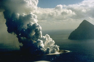
On 18 January, fishermen observed a large white plume rising to more than 3 km altitude and lava being ejected to about 300 m height form the vicinity of the submarine volcano Fukutoku-Okanoba. The eruption was first evident on infrared imagery from the Japanese GMS geostationary weather satellite on 18 January at 2100. Japan Maritime Self-Defense Force personnel stationed on Iwo-Jima, about 50 km from Fukutoku-Okanoba, observed a 4-km eruption cloud the next day at 1630. The Japan Maritime Safety Agency's survey ship Takuyo found a new island about 5 km NE of Minami Iwo Jima (south Iwo Jima) the morning of 21 January. The new island, about 700 m long and 300 m wide, extended about 15 m above sea level. Lava was being ejected to about 300 m height. As of 21 January, floating pumice had drifted 60 km to the SE.
Geological Summary. Fukutoku-Oka-no-ba is a submarine volcano located 5 km NE of the island of Minami-Ioto. Water discoloration is frequently observed, and several ephemeral islands have formed in the 20th century. The first of these formed Shin-Ioto ("New Sulfur Island") in 1904, and the most recent island was formed in 1986. The volcano is part of an elongated edifice with two major topographic highs trending NNW-SSE, and is a trachyandesitic volcano geochemically similar to Ioto.
Information Contacts: JMA, Tokyo; UPI; AP