Report on Fukutoku-Oka-no-Ba (Japan) — January 1986
Scientific Event Alert Network Bulletin, vol. 11, no. 1 (January 1986)
Managing Editor: Lindsay McClelland.
Fukutoku-Oka-no-Ba (Japan) New island formed
Please cite this report as:
Global Volcanism Program, 1986. Report on Fukutoku-Oka-no-Ba (Japan) (McClelland, L., ed.). Scientific Event Alert Network Bulletin, 11:1. Smithsonian Institution. https://doi.org/10.5479/si.GVP.SEAN198601-284130
Fukutoku-Oka-no-Ba
Japan
24.285°N, 141.481°E; summit elev. -29 m
All times are local (unless otherwise noted)
An eruption . . . built a small island in mid-January. Only milky blue discolored sea water was observed near the volcano on 16 January at about 1200. By 18 January at 2000, eruptive activity was frequent, producing a dark plume, seen from a fishing boat, that reached 3,000-4,000 m height. An hour later the plume was evident on an image from Japan's GMS satellite. The next day at about 1630, airborne radar detected a plume rising to 4,000 m above sea level. On 20 January at 0440, radar on the JMSA's survey ship RV Takuyo showed an island-like image. A gray plume rose to 2,000 m altitude at 0550.
A new island was recognized by observers on the RV Takuyo at 0630. A 50-m vent at the NW edge of the new island ejected plumes and sea water. Continuous observations were made until about 1000. The island was ~700 m long, 500 m wide, and 15 m high (figure 2). A vent near its E edge remained below sea level, ejecting black incandescent rocks as much as 10 m in diameter. Grayish brown pumice had drifted as much as 18 km NE from the vent. Discolored sea water surrounded the island and extended 22 km NE from the vent. The sea water was greenish near the island, gradually becoming greenish yellow or pale blue farther from the vent.
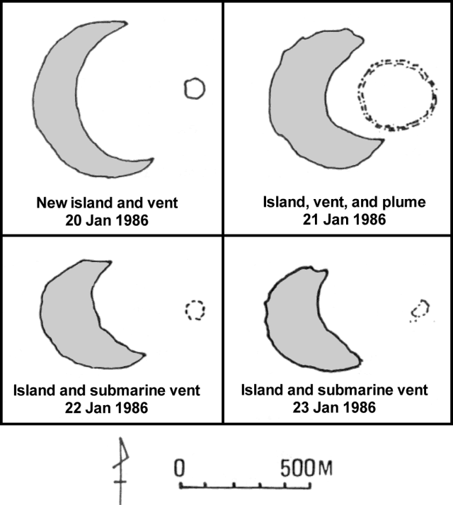 |
Figure 2. Sketch maps of the new island and associated vent and plume at Fukutoku-Okanoba, 20-23 January 1986. Courtesy of JMA. |
At 1122 a dark plume containing incandescent rocks to 10 m in diameter rose 1,200-1,300 m above sea level; between 1250 and 1400 a vapor plume rose to 3,000 m. There was a zone of discolored water ~45 km long and 2-3 km wide. Between 1450 and 1550, explosions occurred at about 20-minute intervals, expelling dark plumes that rose ~1,200-1,700 m. Between 1600 and sunset, 90 weak to moderate explosions ejected plumes to 100-1,000 m height. Volcanic flame was occasionally seen within dark plumes at night.
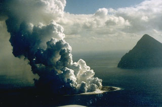
The next morning at 0800 explosions produced small plumes (less than 50 m high) at intervals of 1-2 minutes. At 1223, a large explosion was seen; volcanic flame reached 1,500 m above sea level, roughly half of the plume's height. At 1300 the island was flat and crescent-shaped, covered with ash and pumice but no lava flow. The outer arc of the crescent was a portion of a circle ~700 m in diameter having a center that roughly coincided with the position of the active vent, which was ~300 m in diameter (figures 3 and 4). An area of thin yellow or green discoloration extended SSE to 2 km from the island. Pumice drifted E and S.
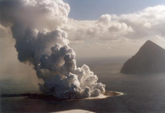 |
Figure 3. Photograph of the new island and eruption plume at Fukutoku-Okanoba on 21 January 1986 at about 1400. The conical island in the right background is Minami-Iwo-jima. Photo by G. Iwashita, JMA. |
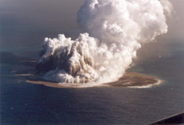 |
Figure 4. Photograph of the new island and eruption plume at Fukutoku-Okanoba on 21 January 1986 at about 1600. Photo by G. Iwashita, JMA. |
By the morning of the 22nd explosive activity had subsided; no plumes were seen for the rest of the month. Erosion of the shoreline of the new island was evident early the next day. However, at 1300 outflow of discolored sea water suggested that the submarine vent, 80 m in diameter, was still active ~400 m E of the island.
The island, covered with gray ash, was ~500 m in length and had a maximum width of 200 m. During the morning of 25 January, dense blue discoloration was seen around and E of the island and had drifted somewhat eastward, to ~9 km from the vent. On the 29th the island's size was estimated at ~600 m long, ~400 m wide and ~10 m high (this preliminary estimate does not necessarily indicate growth since the 23rd). Yellowish green discoloration extended as much as 38 km to the NE, and brown pumice was floating in lines near the island.
Between 20 December and 20 January, nearly 100 T-phase waves of moderate intensity were received by high-gain seismic stations at Rangiroa, Tuamoto Islands (~9,000 km SE of Fukutoku-Okanoba). J.M. Talandier noted that T-phase waves are characteristic of submarine eruptions, having shallow (ocean) depth. The origin of these waves was in the NW Pacific, and they may be related to the eruption of Fukutoku-Okanoba.
Discolored water has frequently been observed around Fukutoku-Okanoba in recent years. In an interview on a Japan Broadcasting Network newscast, Professor Kosaka of Okayama Univ reported that about 8 years ago a sonar survey from the Tokyo Fisheries Univ ship Seio-maru detected a seamount with a summit 40 m below sea level and roughly 150 m wide, beneath the discolored water zone at Fukutoku-Okanoba. Small islands were formed during the 1904-1905 and 1914 eruptions, but did not persist after 1905 and 1916. An island was reported during an eruption on 24 December 1974, but was not visible the next day.
Geological Summary. Fukutoku-Oka-no-ba is a submarine volcano located 5 km NE of the island of Minami-Ioto. Water discoloration is frequently observed, and several ephemeral islands have formed in the 20th century. The first of these formed Shin-Ioto ("New Sulfur Island") in 1904, and the most recent island was formed in 1986. The volcano is part of an elongated edifice with two major topographic highs trending NNW-SSE, and is a trachyandesitic volcano geochemically similar to Ioto.
Information Contacts: JMA; J. Talandier, Laboratoire de Geophysique, Tahiti; NHK Japan Broadcasting Corporation, Tokyo.