Report on Tacana (Mexico-Guatemala) — January 1986
Scientific Event Alert Network Bulletin, vol. 11, no. 1 (January 1986)
Managing Editor: Lindsay McClelland.
Tacana (Mexico-Guatemala) Two months of increased seismicity
Please cite this report as:
Global Volcanism Program, 1986. Report on Tacana (Mexico-Guatemala) (McClelland, L., ed.). Scientific Event Alert Network Bulletin, 11:1. Smithsonian Institution. https://doi.org/10.5479/si.GVP.SEAN198601-341130
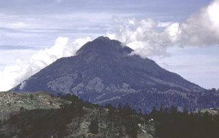
Tacana
Mexico-Guatemala
15.132°N, 92.109°W; summit elev. 4064 m
All times are local (unless otherwise noted)
A series of shallow earthquakes centered within 20 km of Tacaná began 15-16 December and was continuing in early February. On 19 December, a magnitude 5 earthquake centered near Ixchiguan at 15.18°N, 91.99°W (about 15 km ENE of the volcano) caused minor damage to 60 adobe houses and a school built of reinforced concrete. This event was followed by a series of aftershocks that had ended by 30 January.
UNAM geologists from the UNAM visited the volcano in late January, finding no evidence of increased volcanic activity. A temperature of 9°C was measured at 20 cm depth in the summit lava dome. At Agua Caliente hot springs at the foot of the volcano, water temperatures were 50°C; temperature and water outflow rate have apparently remained unchanged for 50 years. A portable seismometer placed on the volcano's summit for 2 hours and at its base for 4 hours on 26 January recorded small earthquakes but no harmonic tremor.
On 3 February, another M 5 earthquake was recorded in the same area as the 19 December event. Moderate damage occurred to 500 adobe houses in the villages of Ixchiguan (18 km ENE of the summit of Tacaná), Calapte, Toacá (13 km NE of the summit), Sanajaba, Sibinal (7 km NE of the summit), Vega del Volcán, María Cecilia, and Toaman. Shocks of magnitudes 4.2, 3.0, and <3.0 followed. Some of the earthquakes had a NW-SE alignment in the Toacá-Ixchiguan area. Volcanic earthquakes were felt in Sibinal and rumbling was heard at the base of the volcano.
A joint INSIVUMEH/UNAM team recorded only volcanic earthquakes 3-7 February. However, [low-level] harmonic tremor began to appear on 8 February. [A signal that could be interpreted as] harmonic tremor strengthened the next day and seismicity was migrating around the volcano.
Geological Summary. Tacaná is a 4064-m-high composite stratovolcano that straddles the México/Guatemala border at the NW end of the Central American volcanic belt. The volcano rises 1800 m above deeply dissected plutonic and metamorphic terrain. Three large calderas breached to the south, and the elongated summit region is dominated by a series of lava domes intruded along a NE-SW trend. Volcanism has migrated to the SW, and a small adventive lava dome is located in the crater of the youngest volcano, San Antonio, on the upper SW flank. Viscous lava flow complexes are found on the north and south flanks, and lobate lahar deposits fill many valleys. Radial drainages on the Guatemalan side are deflected by surrounding mountains into the Pacific coastal plain on the SW side of the volcano. Historical activity has been restricted to mild phreatic eruptions, but more powerful explosive activity, including the production of pyroclastic flows, has occurred as recently as about 1950 years ago.
Information Contacts: S. de la Cruz-Reyna, UNAM, México D.F.; E. Sánchez, Carlos Martínez, and Edgar Quevec R., INSIVUMEH.