Report on Fukutoku-Oka-no-Ba (Japan) — February 1986
Scientific Event Alert Network Bulletin, vol. 11, no. 2 (February 1986)
Managing Editor: Lindsay McClelland.
Fukutoku-Oka-no-Ba (Japan) New island erodes; floating pumice
Please cite this report as:
Global Volcanism Program, 1986. Report on Fukutoku-Oka-no-Ba (Japan) (McClelland, L., ed.). Scientific Event Alert Network Bulletin, 11:2. Smithsonian Institution. https://doi.org/10.5479/si.GVP.SEAN198602-284130
Fukutoku-Oka-no-Ba
Japan
24.285°N, 141.481°E; summit elev. -29 m
All times are local (unless otherwise noted)
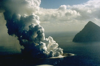
The island formed 20 January . . . has been eroded away by wave action since volcanic activity ceased. The island's disappearance was reported by the JMSDF after an hour-long helicopter flight that began 8 March at 0745. The surface of the new edifice was seen under white water, and there was no sign of a volcanic plume.
On 28 January, airplane pilots observed light brown floating pumice within a roughly rectangular NW-SE-trending zone ~200 km long by 50 km wide, extending from ~100 to 300 km SE of the volcano. The pumice was in subparallel teardrop-shaped rafts roughly 4 km wide and 10 km long, elongate perpendicular to the apparent direction of drift.
Rocks collected from Fukutoku-Okanoba after previous eruptions in 1904, 1914, and 1982 were trachyandesites with high alkali contents.
Geological Summary. Fukutoku-Oka-no-ba is a submarine volcano located 5 km NE of the island of Minami-Ioto. Water discoloration is frequently observed, and several ephemeral islands have formed in the 20th century. The first of these formed Shin-Ioto ("New Sulfur Island") in 1904, and the most recent island was formed in 1986. The volcano is part of an elongated edifice with two major topographic highs trending NNW-SSE, and is a trachyandesitic volcano geochemically similar to Ioto.
Information Contacts: M. Matson, NOAA/NESDIS; Kyodo Radio, Tokyo; UPI.