Report on Erebus (Antarctica) — March 1986

Scientific Event Alert Network Bulletin, vol. 11, no. 3 (March 1986)
Managing Editor: Lindsay McClelland.
Erebus (Antarctica) Lava lake returns; weak SO2 emission
Please cite this report as:
Global Volcanism Program, 1986. Report on Erebus (Antarctica) (McClelland, L., ed.). Scientific Event Alert Network Bulletin, 11:3. Smithsonian Institution. https://doi.org/10.5479/si.GVP.SEAN198603-390020
Erebus
Antarctica
77.53°S, 167.17°E; summit elev. 3794 m
All times are local (unless otherwise noted)
"Mt. Erebus has been in a continuous eruptive phase since 1972, when a small anorthoclase phonolite lava lake was discovered. From 1972 until about 1976 the lava lake expanded to a semi-circle about 60 m in diameter (figure 7, left). There was little change until 13 September 1984, when a significant increase in activity occurred, peaking during September and early October but remaining at significantly higher levels than the preceding 12 years until January 1985 (9:9-10 and 10:3). Previously, small Strombolian eruptions, which occurred 2-6 times/day, had occasionally ejected bombs from the 220-m-deep inner crater floor onto the main crater rim. During the increased activity, bombs averaging 2 m long and reaching more than 10 m in length were dispersed radially around the crater rim, to 1.2 km (horizontally) from the center of eruption in the inner crater. The eruptions were witnessed from 60 km distance and the explosions could be heard from 2 km.
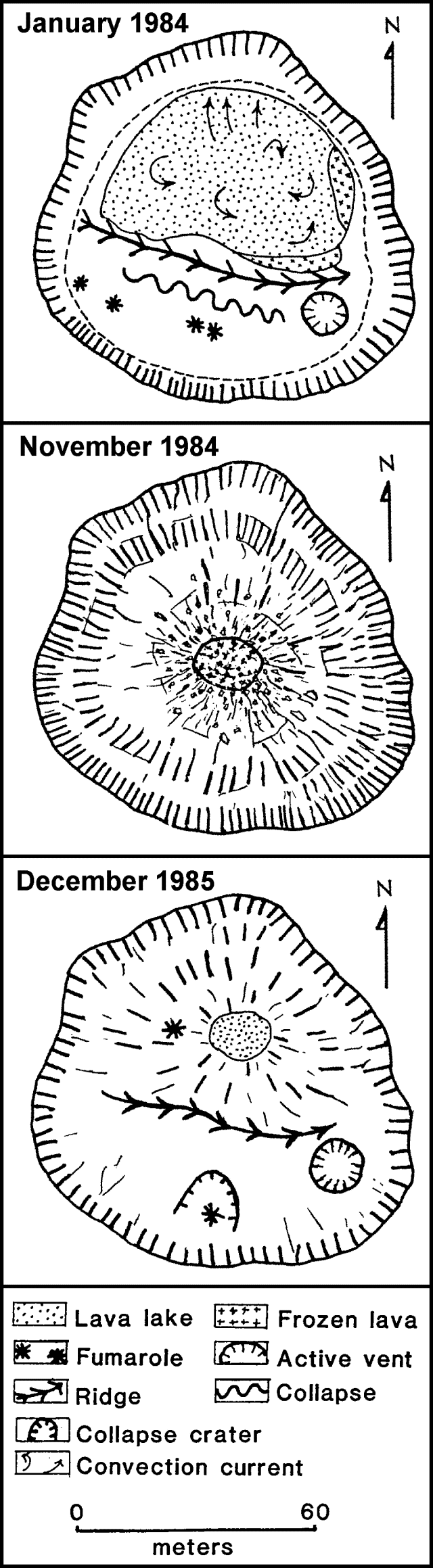 |
Figure 7. Sketch map showing the inner crater at Mt. Erebus in January 1984 (top), November 1984 (middle), and December 1985 (bottom). Courtesy of Philip Kyle. |
"Inspection of the volcano in October, November, and December 1984 showed that the lava lake was gone (figure 7, middle). An initial interpretation was that the lava lake had frozen over and was domed up. However, observations in December 1985 suggest that the inner crater was partially filled with ejecta from the eruptions.
"By December 1985, the inner crater showed some resemblance to its morphology and form prior to September 1984 (figure 7, bottom). A small lava lake, ~15 m in diameter, was in a site similar to that of the former lake. The elevation of the new lake was not measured, but it appeared similar to the 1983 lake. The active vent, a small explosion crater adjacent to the lava lake, had re-formed and a small crater was seen around the site of a fumarole that had been active prior to September 1984. The overall impression of the activity was that the magma column height and position had not changed significantly for the past 14 years. The late 1984 eruption partially filled the inner crater with ejecta that obscured the magma column. Since then, the ejecta have been assimilated back into the magma column or ejected by small eruptions from the lava lake and active vent.
"Ground-based COSPEC SO2 flux measurements made on 17 December 1985 showed cyclic variations of 5-20 t/d with a period of about 2.5 hours. The average SO2 flux was ~12-15 t/d. Seismicity during 1985 was variable (figure 8), showing high levels from mid-February to early April and throughout June and July. From August to December, the activity was extremely quiet."
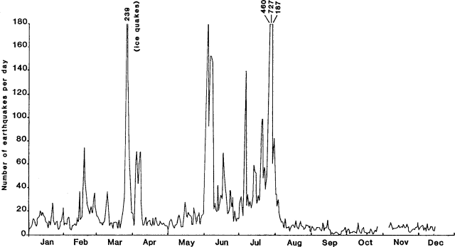 |
Figure 8. Number of local earthquakes/day at Mt. Erebus recorded by the seismometer at Hooper Shoulder during 1985. Courtesy of K. Kaminuma. |
Further Reference. Kaminuma, K., 1987, Seismic activity of Mt. Erebus volcano, Antarctica, in Okal, E.A., ed., Advances in Volcanic Seismology: Pure and Applied Geophysics, v. 125, p. 993-1008.
Geological Summary. Mount Erebus, the world's southernmost historically active volcano, overlooks the McMurdo research station on Ross Island. It is the largest of three major volcanoes forming the crudely triangular Ross Island. The summit of the dominantly phonolitic volcano has been modified by one or two generations of caldera formation. A summit plateau at about 3,200 m elevation marks the rim of the youngest caldera, which formed during the late-Pleistocene and within which the modern cone was constructed. An elliptical 500 x 600 m wide, 110-m-deep crater truncates the summit and contains an active lava lake within a 250-m-wide, 100-m-deep inner crater; other lava lakes are sometimes present. The glacier-covered volcano was erupting when first sighted by Captain James Ross in 1841. Continuous lava-lake activity with minor explosions, punctuated by occasional larger Strombolian explosions that eject bombs onto the crater rim, has been documented since 1972, but has probably been occurring for much of the volcano's recent history.
Information Contacts: P. Kyle, New Mexico Institute of Mining and Technology; K. Kaminuma, National Institute of Polar Research, Japan.