Report on Augustine (United States) — April 1986
Scientific Event Alert Network Bulletin, vol. 11, no. 4 (April 1986)
Managing Editor: Lindsay McClelland.
Augustine (United States) New lava dome in summit crater; details on pyroclastic flows and seismicity
Please cite this report as:
Global Volcanism Program, 1986. Report on Augustine (United States) (McClelland, L., ed.). Scientific Event Alert Network Bulletin, 11:4. Smithsonian Institution. https://doi.org/10.5479/si.GVP.SEAN198604-313010
Augustine
United States
59.3626°N, 153.435°W; summit elev. 1218 m
All times are local (unless otherwise noted)
M.E. Yount and T. Miller report that "A USGS overflight of Augustine on 24 April established the presence of new lava dome material in the moat between the remnants of the 1976 dome and the SW rim of the summit crater. Hot blocks were spalling off the NW side of the new dome, avalanching down a gully on the W side of the 1976 dome. Small ash-rich fumaroles were active on the 1976 dome's entire N flank. During the flight, a burst of white vapor that lasted for several minutes appeared from the 1976 dome's NW base. Observers on a night flight 24 April, using US Army night vision goggles, were able to see incandescent material all around the 1976 dome. Although the summit was obscured on 25 April, observers were able to see a blocky flow in the chute on the 1976 dome's E side. On 27 April it was apparent that the lava flow originated from the summit crater, draping the E side of the 1976 dome. Small pyroclastic flows were observed that day on the 1976 dome's NW side. Samples collected on 28 April from the toe of the lava flow are silicic andesite, as are breadcrusted pumiceous material from the pyroclastic flows. By 6 May, the flow had descended to an elevation of ~600 m through the breached N side of the crater. Seismicity indicated that the dome was actively building between approximately 22 April and the late evening of 28 April, when the almost constant tremor abruptly died out." [The onset of dome growth is given by Swanson and Kienle (1988; see Further References in SEAN 11:08) as 23 April].
Juergen Kienle reports that "After the strong explosive activity that began on 27 March and ended with a major explosion on 31 March at 0952, the volcano was visited by helicopter on 19 and 28 April and 6 May. The following are preliminary results from those field investigations.
Pyroclastic flows. "A 19 April Landsat 5 image clearly shows the light-colored pyroclastic flow deposits that were emplaced 27-31 March on the N flank of the volcano, covering an area of 11 km2 (figure 7). March 31 was the only day on which pyroclastic flows entered the sea, 5 km from the vent. A strong odor of Halogen gas (Cl2, possibly F2, Br2) was detected when crossing the still-steaming areas where flows had entered the sea. The flows were strongly inflated on 19 April, almost 3 weeks after emplacement.
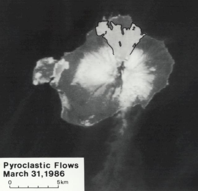 |
Figure 7. Landsat-5 image (no. 5077920515) of Augustine on 19 April. Pyroclastic flows erupted 31 March onto the N flank are outlined in black. Points 1 and 2 mark stations where temperature measurements were taken. The distance from the summit to the shore at point 2 is 5.0 km. |
"With every step we (Kienle, Miller, Power) took, we sank up to our knees into the still hot fluidized flow tops. Temperatures measured at depths of 5 cm in active fumarole pipes and fissures (which were actively elutriating fines) on the NW and NE flow lobes were 550°C (at location 1) and 339°C (at location 2) (figure 7). Driftwood on the beach was charred; one log was charcoaled, indicating that it had caught on fire. The NW flow lobe had buried a former fresh-water lake and a brackish-water swamp area. In that area we noted several small phreatic explosion craters, about 10 m in diameter.
"Levee-forming pumice blocks were typically up to 50 cm in diameter with rounded edges. There were rare banded pumices and occasional breadcrusted blocks. Individual flow units were about 3-5 m thick. The bulk chemistry of one of the breadcrusted blocks is given in table 3 (sample 4).
Table 3. X-ray fluorescence analyses of Augustine's 1986 eruptive products (normalized to 100% anhydrous) by Christopher Nye. * Total iron expressed as Fe2O3 (FeO = 0.9 x Fe2O3).
| Date | 28 Mar 1986 | 31 Mar 1986 | 31 Mar 1986 (?) | 31 Mar 1986 (?) | 28 Apr 1986 |
| Sample | Ash | Ash | Bomb | Pumice flow | Dome fragment |
| Location | Stariski State Park (100 km NE) | English Bay (90 km E) | near VABM Kamishak | N flank | -- |
| Collector | S. Estes | G. Harris | J. Kienle | J. Kienle | T. Miller |
| SiO2 | 65.46 | 64.53 | 61.76 | 62.15 | 60.17 |
| Al2O3 | 16.25 | 16.59 | 16.68 | 16.75 | 17.05 |
| Fe2O3* | 4.62 | 4.82 | 5.92 | 5.75 | 6.30 |
| CaO | 5.66 | 5.81 | 6.64 | 6.50 | 7.31 |
| Na2O | 3.85 | 3.98 | 3.69 | 3.75 | 3.52 |
| MgO | 2.14 | 2.31 | 3.50 | 3.29 | 3.88 |
| K2O | 1.25 | 1.20 | 1.00 | 1.03 | 0.92 |
| TiO2 | 0.53 | 0.52 | 0.54 | 0.53 | 0.57 |
| P2O5 | 0.14 | 0.15 | 0.15 | 0.14 | 0.14 |
| MnO | 0.09 | 0.09 | 0.13 | 0.12 | 0.13 |
| LOI | 0.36 | 0.19 | 0.16 | 0.13 | -0.04 |
| Total | 99.75 | 100.34 | 100.40 | 100.05 | 100.69 |
| FeO/MgO | 1.94 | 1.88 | 1.52 | 1.57 | 1.46 |
| CaO/Al2O3 | 0.35 | 0.35 | 0.40 | 0.39 | 0.43 |
"A crude estimate of the 31 March pyroclastic flow volume can be obtained by assuming an average thickness of the flows of 10 m (we estimate about 8 m for the lower half of the pumice plain and in excess of 20 m for the upper part of the flow fan just below "Hells Gate," near the S end of the area outlined in black in figure 7. Using 11 km2 we obtain 0.11 km3 of inflated ejecta.
Seismicity. "Since 4 April, when violent explosive activity subsided, we have not registered explosion earthquakes at seismic station OPT, 28 km N of the volcano. Individual locatable earthquakes are now rarely recorded. Figure 8 shows a count of individual pyroclastic flows (or rock avalanches) 31 March-10 May. The plot thus essentially shows periods of intense dome deformation. Figure 9 shows one of the avalanches that would have been counted, descending the N flank of the volcano to about the 750 m level. It was photographed from our N flank seismic station 2 km from the vent on 19 April at 1411. That station was damaged and a solar panel was incinerated by a hot blast associated with pyroclastic flow activity on 31 March. Parts of the installation protruding above ground (antennas, masts, and solar panel) were pockmarked with dents from flying rock. Fortunately the buried electronics box and batteries were not damaged and the station has continued to operate uninterruptedly up to 10 May. Significant avalanche activity was observed 20 April-10 May, a period of strong dome transformation. Figure 10 is a hypocentral cross section for events occurring 27 March-27 April. The plot shows that most earthquakes occurred in the upper 2 km of the volcano.
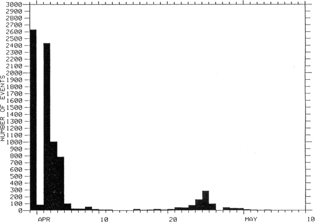 |
Figure 8. Number of pyroclastic flows and rock avalanches recorded at the flank seismic station 3 km from the summit. Counted events had amplitudes larger than 5 mm on that seismometer's record. |
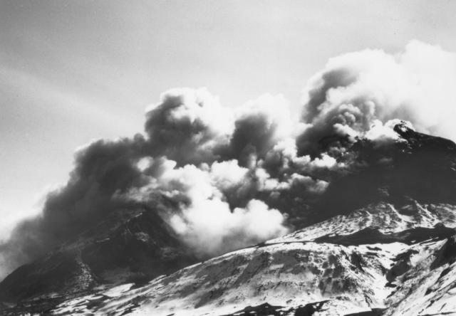 |
Figure 9. Pyroclastic flow, 19 April at 1411, photographed by Juergen Kienle from 3 km N of the summit. |
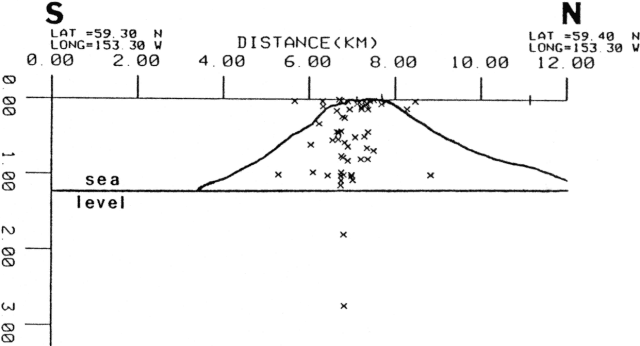 |
Figure 10. Cross-section showing depths of local earthquakes 27 March-April. Plot by Charlotte Rowe. |
"A seismic curiosity: On 28-29 April and 3-6 May, we recorded thousands of small earthquakes with nearly identical wave forms and magnitudes. Scaling of the time interval between events for a 15-minute period showed a periodicity of 12 ± 2 seconds (77 events). Figure 11 is a digital playback for 3 individual events showing their great similarity. The events occur at the central conduit of the volcano at ~750 m elevation (near station AUH). We speculate that they are produced by meltwater contacting the central glowing conduit and flashing the water rhythmically to steam. On 6 May, Tom Miller thought that he could see puffing of the eruption column in spite of the strong winds that drove the plume down to the shore. He also noted that new snow had fallen and was melting.
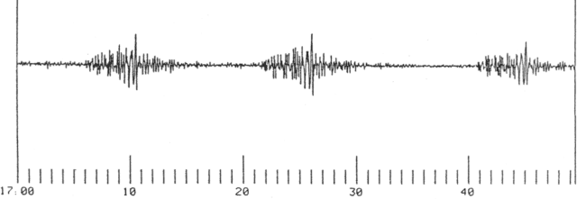 |
Figure 11. Three nearly identical wavetrains of rhythmic events recorded on 5 May at a seismic station less than 1 km NW of the summit. |
Dome growth. "The 1976 dome was never cleared out in any individual explosion, but was slowly transformed into a new dome by magma intrusions and extrusions starting 31 March. As of 6 May its height was 460 m with a base diameter of 400 m and a volume of about 0.06 km3 (figure 12). Its surface was blocky and spiny. An active vent was located in the SSW corner of the crater, a source of numerous boil-over pyroclastic flows. Slabs of glowing rock frequently spilled off the N face of the dome as seen by Kienle on 28 April.
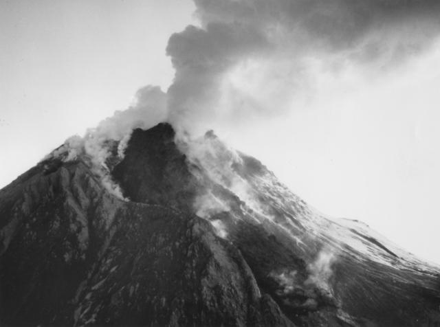 |
Figure 12. New dome photographed from the N on 6 May by Juergen Kienle. |
Chemistry. Five XRF chemical analyses of 1986 ejecta are listed in table 3. The bulk chemistry shows an interesting trend toward less silicic magma as the eruption proceeded. Ballistic bombs collected on 19 April on the S flank (near Bench Mark Kamishaki sample 3) and a breadcrust block (sample 4) collected from the NE lobe of the pyroclastic flows are believed to have been ejected on 31 March. They are very similar in chemistry, showing about 62% SiO2 content. In contrast, the new dome rock collected on 28 April by Tom Miller shows a more basic bulk chemistry with an SiO2 content of about 60%, suggesting the tapping of deeper levels in the magma chamber (less than 2 km deep, based on the seismic data). The high SiO2 content (64.5% and 65.6%) of the distal tephras from the 28 and 31 March eruptions probably reflect aeolian fractionation.
Summary. The 1986 eruption of Augustine has thus far followed a quite different course from the 1976 eruption, which began with a violent vent-clearing phase, followed by a 14-day repose, in turn followed by intrusion of a new dome. During the present eruption, a vent-clearing phase never occurred. The pre-existing dome was slowly transformed into a new dome. March 31 was the only day of substantial production of highly vesiculated magma, ejected as large blocks on all flanks of the volcano but predominantly as pyroclastic flows down the N flank. There are no sub-plinian pumice fall deposits on the island. A pathway for the vesiculating material was probably eroded out of the pre-existing conduit (the 1976 dome) on 31 March. This open conduit continues to produce occasional small-volume pyroclastic flows and was the source of the peculiar "percolator-like" seismicity described above, as meltwater interacted with new hot conduit rock. The most remarkable feature of the 1986 eruption thus far is how well lithostatic pressure has confined the eruption, which was never particularly violent in spite of the fact that the beginning phase shows clear evidence of phreato-magmatic processes due to the interaction of ground water near sea level with the rising magma. If any of the pre-existing structures (1935 dome, 1964 dome, or 1976 dome) had collapsed catastrophically, the unloading would have very likely produced much more violent activity."
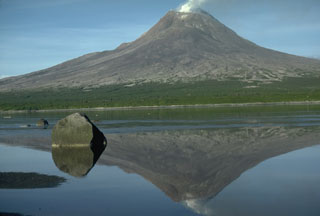
Geological Summary. Augustine volcano, rising above Kamishak Bay in the southern Cook Inlet about 290 km SW of Anchorage, is the most active volcano of the eastern Aleutian arc. It consists of a complex of overlapping summit lava domes surrounded by an apron of volcaniclastic debris that descends to the sea on all sides. Few lava flows are exposed; the flanks consist mainly of debris-avalanche and pyroclastic-flow deposits formed by repeated collapse and regrowth of the summit. The latest episode of edifice collapse occurred during Augustine's large 1883 eruption; subsequent dome growth has restored the edifice to a height comparable to that prior to 1883. The oldest dated volcanic rocks on Augustine are more than 40,000 years old. At least 11 large debris avalanches have reached the sea during the past 1,800-2,000 years, and five major pumiceous tephras have been erupted during this interval. Recorded eruptions have typically consisted of explosive activity with emplacement of pumiceous pyroclastic-flow deposits followed by lava dome extrusion with associated block-and-ash flows.
Information Contacts: J. Kienle, C. Rowe, J. Power, and L. Gedney, Geophysical Institute, University of Alaska, Fairbanks; C. Nye and J. Davies, Alaska Division of Geological and Geophysical Surveys, Fairbanks; M.E. Yount and Tom Miller, Branch of Alaskan Geology, USGS Anchorage.