Report on Wrangell (United States) — April 1986
Scientific Event Alert Network Bulletin, vol. 11, no. 4 (April 1986)
Managing Editor: Lindsay McClelland.
Wrangell (United States) Twenty years of increased heat flow; crater ice melts; fumarole temperatures increase; larger plumes
Please cite this report as:
Global Volcanism Program, 1986. Report on Wrangell (United States) (McClelland, L., ed.). Scientific Event Alert Network Bulletin, 11:4. Smithsonian Institution. https://doi.org/10.5479/si.GVP.SEAN198604-315020
Wrangell
United States
62.006°N, 144.017°W; summit elev. 4278 m
All times are local (unless otherwise noted)
University of Alaska geologists have documented a major long-term increase in heat flux at Mt. Wrangell, an andesitic shield volcano with a summit caldera 6 km long, 4 km wide, and 1 km deep. Heat flux from a crater on the N side of the summit caldera rim has increased by an order of magnitude since the great earthquake of 1964 (magnitude 8.3) centered ~250 km to the SW. Annual aerial photogrammetric surveys and digital cross sections demonstrate that since 1965 about 85% of the 4.4 x 10⁷ m3 of ice in the north crater (figure 1) has melted; all melting at that altitude is caused by volcanic heat. Fumaroles remained at the boiling point (86°C at 600 mb pressure) from 1961 through the late 1970's, but some superheating may have begun by 1980, and in 1982 superheating was evident as vapor rose 1 m above the vents before condensing. In 1985, a temperature of l92°C was measured at the edge of one fumarole. The fumarole gases were dominantly water, but the SO2 content of the dry fraction was 28% in 1982 and 35% in 1985; most of the remaining gas was CO2 (gases were collected by Roman Motyka and Matthew Sturm, 1982, Matthew Sturm and Daniel Solie, 1985; analyses by W. Evans, USGS, and Roman Motyka).
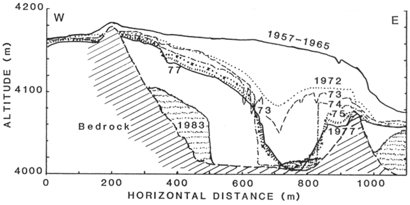 |
Figure 1. E-W cross-section of Wrangell's N crater, showing changes in the ice volume of the crater between 1957 and 1983; after Benson and Motyka (1978) and Benson and others (1984). |
During April 1986, nearby residents reported occasional plumes rising as much as 1 km above the summit, with several observations of large plumes the last week of the month. On 30 April, the plume was estimated to be 1 km high and 300 m wide. Geologists plan overflights to monitor the activity.
References. Benson, C., and Follett, A., 1986, Application of photogrammetry to the study of volcano-glacier interactions on Mt. Wrangell, Alaska: Photogrammetric Engineering and Remote Sensing, v. 52, no. 6, p. 813-827.
Benson, C., and Motyka, R., 1978, Glacier-volcano interactions on Mt. Wrangell, Alaska: Annual Report, Geophysical Institute, University of Alaska, 1977-78, p. 1-25.
Benson, C., Sturm, M., and others, 1984, Glacier-volcano interactions, Mt. Wrangell, Alaska: Annual Report, Geophysical Institute, University of Alaska, 1983-84, p. 102-104.
Geological Summary. Mount Wrangell is one of the world's largest continental-margin volcanoes, with a diameter of 30 km at 2,000 m elevation. The andesitic shield volcano has produced fluid lava flows as long as 58 km and contains an ice-filled caldera 4-6 km in diameter and 1 km deep, located within an older 15-km-wide caldera. Most of the edifice was constructed during eruptions between about 600,000 and 200,000 years ago. Formation of the summit caldera followed sometime between about 200,000 and 50,000 years ago. Three post-caldera craters are located at the broad summit, along the northern and western caldera rim. A steep-sided flank cinder cone, Mount Zanetti, is located 6 km NW of the summit. The westernmost cone has been the source of infrequent eruptions beginning in the 18th century. Increased heat flux in recent years has melted large volumes of ice in the northern crater.
Information Contacts: Carl S. Benson, Geophysical Institute, Univ of Alaska, Fairbanks; Roman Motyka, Alaska Dept of Natural Resources, Juneau.