Report on St. Helens (United States) — April 1986

Scientific Event Alert Network Bulletin, vol. 11, no. 4 (April 1986)
Managing Editor: Lindsay McClelland.
St. Helens (United States) Steam and ash emissions, then new lobe added to the summit lava dome; first activity since May-June 1985
Please cite this report as:
Global Volcanism Program, 1986. Report on St. Helens (United States) (McClelland, L., ed.). Scientific Event Alert Network Bulletin, 11:4. Smithsonian Institution. https://doi.org/10.5479/si.GVP.SEAN198604-321050
St. Helens
United States
46.2°N, 122.18°W; summit elev. 2549 m
All times are local (unless otherwise noted)
The gas-and-ash emission event of 16 April (SEAN 11:03) marked the beginning of increased seismicity and deformation that culminated in the extrusion of a new lobe on top of the lava dome on 8 or 9 May.
Approximately 50 gas-and-ash emissions occurred in the 3 weeks following the onset of activity, emitting plumes to as much as 6 km altitude. On 19 April at 1950, 50-kg blocks were expelled to > 1 km from the vent; some were thrown over the S rim of the crater. Two small mudflows were generated, which were confined to the crater. A new crater 50-75 m N-S, 20-30 m E-W, and 20 m deep was formed on the top of the dome, and the gas sensor, strainmeter, and tiltmeter that were on top of the dome were destroyed. Between 18 and 20 April the tiltmeter on the N side of the dome registered 1,500 µrads of inflation and a line on the crater floor N of the dome shortened 2 cm.
The last of the unusually deep (3-8 km) earthquakes that began on 29 January (SEAN 11:03) was recorded on 13 April. Seismicity remained at background levels for ~10 days following the 16 April emission, with the exception of 20-23 April, when a slight increase was recorded. On 27 April, activity began to increase again. Shallow events increased rapidly on 5 and 6 May. By 7 May, earthquake activity reached high levels (figure 30), prompting the USGS to issue a Volcano Advisory Notice, forecasting a magmatic event within the next few weeks. Seismicity and tilt increased greatly overnight, so the Advisory was revised on 8 May to predict an event within the next few days.
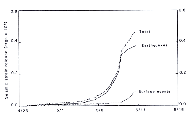 |
Figure 30. Seismic strain release at Mt. St. Helens, 2 April-13 May. The dashed line represents surface events, the solid line earthquakes, and the dotted line total E energy release. Courtesy of C. Jonientz-Trisler. |
In the morning of 8 May, discrete earthquake activity was almost continuous. Larger events with magnitudes of 2.5-3.0 were recorded every few tens of minutes. The tiltmeter on the N flank of the dome went off scale [see also SEAN 11:05], and one on the crater floor 280 m N of the dome registered as much as 85 µrads/hour of inflationary tilt until it leveled off at about 1500 (figure 31). At about that time, high-frequency earthquakes also decreased, and low-frequency events, commonly associated with lava extrusions, became dominant. Field crews in the crater that day measured 7 cm of contraction along a 66-m line on the N crater floor, suggesting that the crater floor was thrusting away from the dome. USGS geophysicists noted that the change in tilt direction and decrease in seismicity probably occurred when magma intruding the dome gained easy access to the summit area and stopped deforming the NE flank. During the mid-afternoon, the first successful gas flight since the onset of gas emission episodes in mid-April measured an SO2 emission rate of 700 t/d, an order of magnitude above rates measured in recent months.
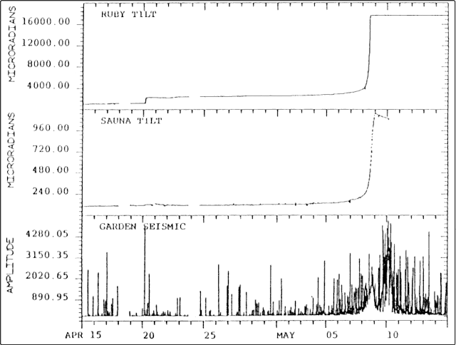 |
Figure 31. Tilt and seismicity at Mt. St. Helens, 14 April-14 May. Tilt plots are from single-axis bubble tiltmeters on the dome's N flank (Ruby, top) and on the crater floor near the N base of the dome (Sauna, middle). Both measure tilt radial to the dome; increasing values correspond to tilt outward from the dome or down to the N. Seismic amplitudes (bottom) are from the Garden. Seismic station, 700 m N of the center of the dome. |
At approximately 1950, another major gas-and-ash emission occurred, ejecting juvenile tephra to the E and SE of the crater. Accompanying the event was a large rockfall from the new lobe. The rockfall moved down the N talus chute, destroying the tiltmeter on the N flank of the dome, and generated a hot surge that moved 600-800 m from the base of the dome. Meltwater generated by the slide and surge caused a water and/or mudflow 1 m deep that tripped flood gauge wires just N of the crater. Gauges downstream did not detect the flow. Scientists flying over the volcano that night saw a glow on top of the lava dome.
During midmorning on 9 May, moderate- to high-frequency events stopped, low-frequency events decreased and rockfalls began to dominate the seismic record for the next 24 hours. On 10 May, moderate- to high-frequency events resumed, but overall seismicity dropped to moderate levels and by 13 May levels were only slightly elevated.
On 14 May, field crews were able to reach the crater to confirm the extrusion of a new lobe on top of the dome. The new lobe was 250-300 m wide (E-W), 275-300 m long (N-S), and > 40 m thick in places, covering the E one quarter to one third of the September 1984 lobe. A broad area of the dome's summit was heavily fissured, with many hot radial cracks low on the S flank of the dome, indicating that intrusive growth had also taken place. Monitoring is limited to the N side of the crater because of snow cover, precluding estimates of dome volume change. The maximum deformation measured between 8 and 14 May was 1.9 m along a line from the N-crater floor to a point on the N flank of the dome. Lines were remeasured after 1 hour and showed no additional change.
The April-May activity was the first since the dome building episode in May-June 1985 (SEAN 10:05), the longest quiet period since eruptive activity began in 1980.
Geological Summary. Prior to 1980, Mount St. Helens was a conical volcano sometimes known as the Fujisan of America. During the 1980 eruption the upper 400 m of the summit was removed by slope failure, leaving a 2 x 3.5 km breached crater now partially filled by a lava dome. There have been nine major eruptive periods beginning about 40-50,000 years ago, and it has been the most active volcano in the Cascade Range during the Holocene. Prior to 2,200 years ago, tephra, lava domes, and pyroclastic flows were erupted, forming the older edifice, but few lava flows extended beyond the base of the volcano. The modern edifice consists of basaltic as well as andesitic and dacitic products from summit and flank vents. Eruptions in the 19th century originated from the Goat Rocks area on the N flank, and were witnessed by early settlers.
Information Contacts: D. Swanson, E. Endo, D. Dzurisin, and K. McGee, CVO; C. Jonientz-Trisler, University of Washington.