Report on Concepcion (Nicaragua) — May 1986
Scientific Event Alert Network Bulletin, vol. 11, no. 5 (May 1986)
Managing Editor: Lindsay McClelland.
Concepcion (Nicaragua) Gas and ash emission; flank vegetation killed
Please cite this report as:
Global Volcanism Program, 1986. Report on Concepcion (Nicaragua) (McClelland, L., ed.). Scientific Event Alert Network Bulletin, 11:5. Smithsonian Institution. https://doi.org/10.5479/si.GVP.SEAN198605-344120
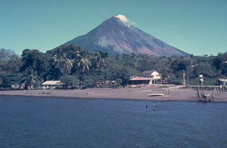
Concepcion
Nicaragua
11.538°N, 85.622°W; summit elev. 1700 m
All times are local (unless otherwise noted)
The following is from Benjamin de Vries, based on observations between 4 February and 8 April. "On 4 February at 1336, a weak eruption was observed, lasting until 1404. Another was recorded between 1542 and 1609. Pulses of ash rose to 100 m above the crater before falling on the W flank and the village of Moyogalpa, on the coast of Lake Nicaragua about 9 km W of the crater. A brown haze from the ash plume extended over the lake. A farmer said that the activity had been continuing for 10 days (since 25 January).
"Throughout the next 2 months, gas and occasional ash emission continued (table 1). Activity was seen almost every time the crater was observed. Three types of activity were seen: ash eruptions, gray gas emission, and white gas clouds; often two types occurred together. The majority of material seemed to come from the S side of the crater, but a fissure N of the crater at about 1,500 m altitude emitted gas during periods of vigorous activity.
Table 1. Summary of volcanic activity observed at Concepción, 25 January-20 April 1986.
| Date | Activity |
| 25-30 Jan 1986 | Ash and gas reported. |
| 04 Feb 1986 | Two short ash eruptions (100-m plume). |
| 05 Feb 1986 | Ash and gas (50-m plume). |
| 06 Feb 1986 | Ash eruption (100-m plume) then white gas emission. |
| 07 Feb 1986 | Ash eruption and gray-white gas emission. |
| 08 Feb 1986 | Gray gas emission. |
| 09 Feb 1986 | Gray gas emission, changing to white in evening. |
| 10 Feb 1986 | White gas (100-m plume). |
| 11 Feb 1986 | Ash eruption at midday (200-m plume). |
| 12-16 Feb 1986 | Low-level gray gas emission. |
| 17-22 Feb 1986 | Continuous emission of white gas. |
| 23 Feb 1986 | Some ash; white-gray gas emission; ash ejection at midday (50-m plume). |
| 24 Feb 1986 | White gas emission, decreasing through the day (below 50 m); some ash. |
| 25 Feb 1986 | Diffuse ash pulses (50 m high) in morning. |
| 16 Mar 1986 | White gas emission around midday. |
| 20 Mar 1986 | Ash and gas emission (50-m plume); brown haze over NW flank and lake. |
| 01-04 Apr 1986 | Continuous white gas emission. |
| 05-07 Apr 1986 | Stronger gas emission (100 m gray-white plume); gas descended gullies; strong smell; slight ash content. |
| 08-20 Apr 1986 | Intermittent activity reported. |
"The white clouds were thought to be dominantly water vapor. The gray gas was sulfurous and could be smelled in villages 10 km away. On the W flanks, gas and ash tended to follow the major gullies. In these gullies, gas was insufferable, causing sore throats and drowsiness (CO2?). The white gas did not produce a noticeable smell and usually disappeared a few hundred meters from the crater.
"The W side of the volcano now has a distinct zone to 3 km from the summit in which vegetation is absent or dead, surrounded by a zone of ailing plant and animal life. This has reached some hamlets above the village of San José (8 km SW of the crater), and some homes have been abandoned.
"There have been many rockfalls, small landslides, and slow-moving flows of ash and cinders on the W and S flanks. These seemed to increase in frequency in April. The SW gully has disgorged a large amount of blocky and fine material since 1983, forming a fan that has engulfed and killed 500 m2 of mature forest. This activity is expected to increase when the rainy season starts in May. Mudflows and landslides are a serious possibility, especially if the eruptive activity continues (figure 1).
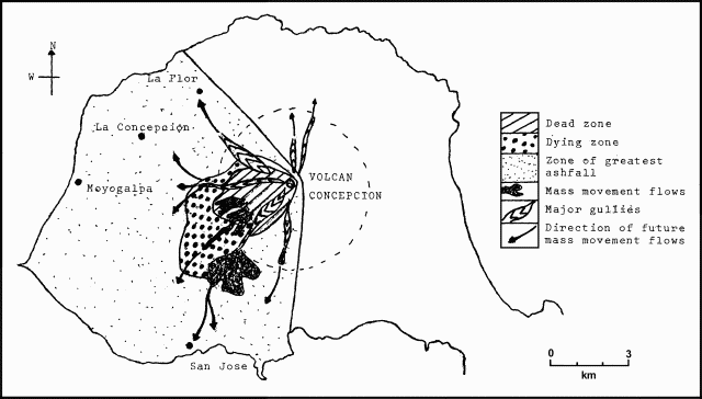 |
Figure 1. Map of Concepción showing zones of dead and dying vegetation, ash deposition, present and possible future mass movement, and gullies, 10 March 1986. Courtesy of Benjamin van Wyk de Vries. |
In early February, eruptions had a 30-hour periodicity and lasted for about 1/2 hour. Later, no particular pattern was detected. Within each eruption, numerous pulses occurred at different frequencies and intensities. Generally, the stronger activity had a higher frequency. High-frequency strong pulses tended to group together between longer periods of lesser activity. Ash eruptions were stronger, rising to 200 m above the crater and occurring in well-separated (>1 minute) groups of pulses."
Geological Summary. Volcán Concepción is one of Nicaragua's highest and most active volcanoes. The symmetrical basaltic-to-dacitic stratovolcano forms the NW half of the dumbbell-shaped island of Ometepe in Lake Nicaragua and is connected to neighboring Madera volcano by a narrow isthmus. A steep-walled summit crater is 250 m deep and has a higher western rim. N-S-trending fractures on the flanks have produced chains of spatter cones, cinder cones, lava domes, and maars located on the NW, NE, SE, and southern sides extending in some cases down to Lake Nicaragua. Concepción was constructed above a basement of lake sediments, and the modern cone grew above a largely buried caldera, a small remnant of which forms a break in slope about halfway up the N flank. Frequent explosive eruptions during the past half century have increased the height of the summit significantly above that shown on current topographic maps and have kept the upper part of the volcano unvegetated.
Information Contacts: B. van Wyk de Vries, London Univ; Douglas Fajardo B., INETER.