Report on Rumble III (New Zealand) — July 1986
Scientific Event Alert Network Bulletin, vol. 11, no. 7 (July 1986)
Managing Editor: Lindsay McClelland.
Rumble III (New Zealand) Submarine activity discolors water; hydrophone noise
Please cite this report as:
Global Volcanism Program, 1986. Report on Rumble III (New Zealand) (McClelland, L., ed.). Scientific Event Alert Network Bulletin, 11:7. Smithsonian Institution. https://doi.org/10.5479/si.GVP.SEAN198607-241130
Rumble III
New Zealand
35.745°S, 178.478°E; summit elev. -220 m
All times are local (unless otherwise noted)
The New Zealand Defence Scientific Establishment reported that hydrophones detected noise of probable volcanic origin, peaking on 15-16 June. About 1 July, hydrophones on Great Barrier Island, ~290 km SW of Rumble III, recorded noise of possible volcanic origin, but detected no activity by 13 July.
On 13-14 July, a Japanese fishing boat reported cream-colored steam rising from the ocean at 35.74°S, 178.49°E, and observed a 500 m2 sulfur slick. No explosions were reported. The New Zealand Meteorological office reported a satellite-derived sea surface temperature anomaly of possibly +2°C in the area 10-14 July.
On an overflight 5 August, Royal New Zealand Air Force observers saw a circular patch of discolored blue water ~40 m across, thought to be a zone of gas-rich water. The discolored water repeatedly vanished and reformed, then dispersed 4-6 km SW. Sonar buoys dropped into the area detected bubbling noises, but no low-frequency or pulsing noises.
Personnel on the HMNZS Tui examined the area of the volcano during the night or 7-8 August between 2300 and 0500. The sea was calm with no discoloration, sulfur smell, or steam. They found a minimum depth of 150 m [but see 15:03], and samples were dredged from ~300 m.
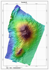
Geological Summary. Rumble III seamount, the largest of the Rumbles group of submarine volcanoes along the South Kermadec Ridge, rises 2,300 m from the seafloor to within about 200 m of the surface. Collapse of the edifice produced a scarp open to the west and a large debris-avalanche deposit. Fresh-looking andesitic rocks have been dredged from the summit and basaltic lava from its flanks. It has been the source of several submarine eruptions detected by hydrophone signals.
Information Contacts: J. Latter, DSIR Geophysics, Wellington; L. Hall, Defence Scientific Establishment, Auckland.