Report on Oku Volcanic Field (Cameroon) — August 1986
Scientific Event Alert Network Bulletin, vol. 11, no. 8 (August 1986)
Managing Editor: Lindsay McClelland.
Oku Volcanic Field (Cameroon) Toxic gas cloud from Lake Nyos kills more than 1,700 people
Please cite this report as:
Global Volcanism Program, 1986. Report on Oku Volcanic Field (Cameroon) (McClelland, L., ed.). Scientific Event Alert Network Bulletin, 11:8. Smithsonian Institution. https://doi.org/10.5479/si.GVP.SEAN198608-224030
Oku Volcanic Field
Cameroon
6.25°N, 10.5°E; summit elev. 3011 m
All times are local (unless otherwise noted)
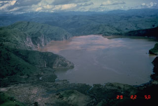
During the evening of 21 August a toxic gas cloud emerged from a lake within a young volcanic crater in NW Cameroon, killing >1,700 people and uncounted numbers of animals. Scientists investigating the disaster suggested that the lake may [be underlain by] a recent diatreme [Kling and others, 1987].
Scientists interviewed many of the survivors (>300 were hospitalized), and took gas and water samples from the lake and streams. Medical and geological investigations suggest that victims were suffocated by CO2 gas; there was no evidence that HCN or CO were present. Many survivors reported that the odor of gunpowder or rotten eggs permeated the area for ~2 days after the event and many had chemical burns on their skin (Koenigsberg and others, 1986). Positions of dead animals suggested that the gas cloud [reached as high as] 100 m above of the lake surface as it moved out of the crater, over low spots in the rim. The CO2-laden cloud blanketed low areas around the lake. Some of the cloud moved N over the outflow, followed two stream valleys for ~1 km, then turned NE along a larger river valley and through the village of Nyos, asphyxiating most of the inhabitants in the area (figure 2). Gas that flowed W from the lake followed the Cha valley for [~15] km, causing many casualties. Portions of the gas cloud had enough density and velocity to knock down corn and banana plants in a few areas as it moved outward. Gas clouds also moved to the S along the inflow streams, spreading over a wide area, and over the E rim into a low-lying pocket.
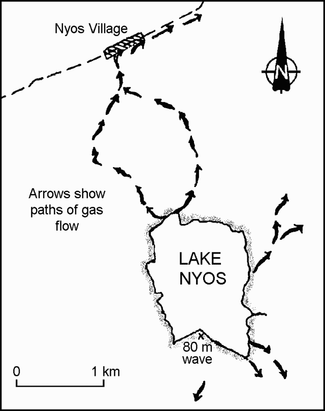 |
Figure 2. Sketch map showing the paths taken by gas flowing from Lake Nyos. [Corrected from original Bulletin.] |
Prior to the event, Lake Nyos had been clear, . . . but afterward the upper 10 m was red/brown in color, and the water had a high CO2 content. No gas bubbles had been observed before the event, nor were there reports of earthquakes. [At the beginning of] the event, however, bubbling and low rumblings were heard by a few people living close to the lake. One witness saw a cloud that appeared to be luminous suspended above the lake for a time. Another witness observed a large surge of water wash onto a small peninsula on the S side of the lake, and F. LeGuern later measured its height at 80 m above the lake. Along the E shore the surge height reached [~6] m and water had overflowed the natural spillway to the N by [~4] m. . . .
[Associated with] the emergence of the cloud, the lake level dropped [by ~1 m]. CO2 apparently continued to emanate from the lake water for several days after the event, as people collapsed at low-lying stream crossings.
A preliminary survey, using a small depth-finder, shows that the lake bottom drops off sharply from ~40 m to a flat crater floor at [208] m. Two shallow channels 15 m deep and 100 m wide extend from the base of the inflow streams and join ~500 m from the shore. The depth survey revealed no evidence of bottom sediment disruption but could not define small structures at [the bottom]. The lake temperature was nearly uniform with surface water at 22°C and bottom water at 23°C. Bicarbonate content of the [bottom] water was high (722 mg/l) and the pH was ~5.15. The surface water was well oxygenated, but the lake was anoxic below 10 m. Water samples were taken at 50, 100, and 150 m; deep water samples effervesced as they were brought to the surface, losing as much as [90%] of their volume. The water was clear at depth with a high iron content that formed a reddish precipitate when exposed to air. Sediments dredged from the lake bottom were clastic, dark brown in color, and had no sulfurous smell.
[The gas has a magmatic source but] the mechanism that triggered its release from the lake remain uncertain. The U.S. scientific team noted that: 1) There is no evidence for a direct volcanic or seismic trigger for the event; however, the nearest seismograph is 150 km SW; 2) Sudden injection of hot volcanic gas through the lake bottom or sudden release of a magmatic gas bubble trapped beneath bottom sediments appear unlikely, since the lake water temperature was low and uniform after the event, and there was no evidence that bottom sediments had been recently disrupted; 3) Slow seepage of low-temperature CO2-rich magmatic gas into the lake could have culminated in a catastrophic gas ejection when solubility limits of bottom water were exceeded; and 4) If the lake had previously been stratified (cooler, denser bottom water underlying a warmer surface layer), mixing or overturn could have brought gas-saturated water from depth to the surface. The resulting pressure drop would then have triggered a rapid gas release. Surface water temperatures are cooler during the rainy season, reducing density contrasts and therefore decreasing the stability of the lake's stratification. Turbulence generated by winds, waves, or a landslide might have triggered an overturn. . . .
During the dry season, the level of Lake Nyos drops, but during the rainy season (May-September), a [45-m] waterfall develops at the outflow. The waterfall spills over a natural dam of pyroclastic deposits, the [bottom 6] m of which are weakly consolidated. Leakage through the [lower, more permeable parts of the] dam, even during the dry season, suggests that it is unstable and poses a hazard to residents in the valley.
George Kling . . . identified 31 crater and maar lakes in NW Cameroon. Many are young and some appear to have formed within the past thousand years. Of the 17 lakes that Kling was able to sample, only Lake Nyos and Lake Monoun contained significant quantities of dissolved CO2. No record of gas emission is known before the 1984 event at Lake Monoun, but no efforts have yet been made to explore the rich oral history of the region.
Geological Summary. Numerous maars and basaltic cinder cones lie on or near the deeply dissected rhyolitic and trachytic Mount Oku massif along the Cameroon volcanic line. The Mount Oku stratovolcano is cut by a large caldera. The Oku volcanic field is noted for two crater lakes, Lake Nyos to the N and Lake Monoun to the S, that have produced catastrophic carbon-dioxide gas release events. The 15 August 1984 gas release at Lake Monoun was attributed to overturn of stratified lake water, triggered by an earthquake and landslide. The Lake Nyos event on 21 August 1986 caused at least 1,700 fatalities. The emission of ~1 km3 of magmatic carbon dioxide has been attributed either to overturn of stratified lake waters as a result of a non-volcanic process, or to phreatic explosions or injection of hot gas into the lake.
Information Contacts: J. Devine, Brown Univ; J. Lockwood, HVO; H. Compton and A. Humphrey, EPA; W. Evans and M. Tuttle, USGS; G. Kling, Duke Univ.