Report on Chikurachki (Russia) — November 1986
Scientific Event Alert Network Bulletin, vol. 11, no. 11 (November 1986)
Managing Editor: Lindsay McClelland.
Chikurachki (Russia) 5-km-high ash column; lava and pyroclastic flow
Please cite this report as:
Global Volcanism Program, 1986. Report on Chikurachki (Russia) (McClelland, L., ed.). Scientific Event Alert Network Bulletin, 11:11. Smithsonian Institution. https://doi.org/10.5479/si.GVP.SEAN198611-290360
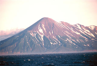
Chikurachki
Russia
50.324°N, 155.461°E; summit elev. 1781 m
All times are local (unless otherwise noted)
Crews of two fishing boats reported that a summit eruption began on 19 November at 1730. At 1807, a 1-km-high eruption column was observed, accompanied by strong electrical discharges. Geologists reported that during the day ash explosions fed a 3-km-high eruption column and a 20-m-thick lava flow, and three pyroclastic flows moved down the SE flank. Satellite images showed a plume extending roughly 350 km to the ENE at 2300. The next day, meteorologists at Cape Vasiliev (25 km SE of the volcano) reported loud rumbling and a large eruption plume. Geologists reported that the plume grew to ~500 km long and that two lava flows descended to 560 m altitude . . . . Five centimeters of ash accumulated 18 km from the vent and ash was also reported ~30 km away.
Plumes were visible on images from Japan's GMS satellite: 120 km long on 20 November at 0431; 300 km at 1031 and 1631; 360 km at 2231; and 400 km on 21 November at 0300 (figure 1). Maximum altitude was ~10.5-11 km, based on a minimum cloud-top temperature of -51°C. Airplane pilots reported ash between 9.5 and 11 km altitude. This prompted the issuance of an official notice to aircraft (SIGMET) on 22 November at 0100, warning of ash within an irregular area bounded by 49°N, 154°E; 48°N, 179°E; 51°N, 178°W; 54°N, 165°E; and 53°N, 153°E. On 23 November, a 5-km-high gas-ash cloud was observed by geologists. Satellite images next showed activity on 24 November at 0300, but plume emission was less vigorous. After 1800, plume activity appeared to have ended. Satellite images on 26 and 30 November revealed possible small plumes that might have indicated continuing ash eruptions. Geologists reported that after 1 December lava production and explosions stopped. Preliminary ejecta volume estimates were ~0.1 km3.
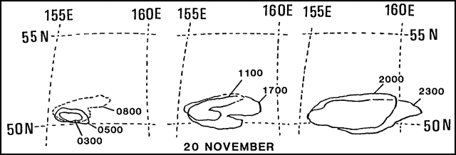 |
Figure 1. Chikurachki's eruption clouds from infrared images of Japan's GMS satellite, 20 November 1986. Courtesy of Yosihiro Sawada. |
Geological Summary. Chikurachki, the highest volcano on Paramushir Island in the northern Kuriles, is a relatively small cone constructed on a high Pleistocene edifice. Oxidized basaltic-to-andesitic scoria deposits covering the upper part of the young cone give it a distinctive red color. Frequent basaltic Plinian eruptions have occurred during the Holocene. Lava flows have reached the sea and formed capes on the NW coast; several young lava flows are also present on the E flank beneath a scoria deposit. The Tatarinov group of six volcanic centers is located immediately to the south, and the Lomonosov cinder cone group, the source of an early Holocene lava flow that reached the saddle between it and Fuss Peak to the west, lies at the southern end of the N-S-trending Chikurachki-Tatarinov complex. In contrast to the frequently active Chikurachki, the Tatarinov centers are extensively modified by erosion and have a more complex structure. Tephrochronology gives evidence of an eruption around 1690 CE from Tatarinov, although its southern cone contains a sulfur-encrusted crater with fumaroles that were active along the margin of a crater lake until 1959.
Information Contacts: B. Ivanov, G. Bogoyavlenskaya, and A. Khrenov, IV; M. Matson, W. Gould, and S. Kusselson, NOAA/NESDIS; G. Steinberg, Yuzhno-Sakhalinsk; Y. Sawada, JMA; Sovietskaya Rossiya newspaper, Moscow; AP.