Report on Ruapehu (New Zealand) — December 1986

Scientific Event Alert Network Bulletin, vol. 11, no. 12 (December 1986)
Managing Editor: Lindsay McClelland.
Ruapehu (New Zealand) Crater lake cools
Please cite this report as:
Global Volcanism Program, 1986. Report on Ruapehu (New Zealand) (McClelland, L., ed.). Scientific Event Alert Network Bulletin, 11:12. Smithsonian Institution. https://doi.org/10.5479/si.GVP.SEAN198612-241100
Ruapehu
New Zealand
39.28°S, 175.57°E; summit elev. 2797 m
All times are local (unless otherwise noted)
Crater Lake cooled rapidly from 34°C on 20 November to 12°C on 17 December, reversing a continuous rise that began in late July (figure 7). On 17 December, geologists saw no sign of recent surging or upwelling, but lake-surface conditions hampered detailed observations. Most of the lake remained gray but areas along the N and E shores had cleared to a blue-green color. Sulfur slicks were observed in the center of the lake but no gas smell was detected. Slight deformation, consistent with continuing minor inflation, was recorded by electronic distance measurements (figure 7). The recent [heating] episode appears to have ended without a recorded eruption.
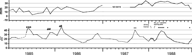 |
Figure 7. Distance change across the N part of the Ruapehu crater, January 1985-December 1989 (top). Crater width was 600.013 m when first measured in February 1976. Standard error is ±3 mm for a single survey. Lake temperature during the same period (bottom). Clouds above the temperature graph represent small hydrothermal eruptions. |
Geological Summary. Ruapehu, one of New Zealand's most active volcanoes, is a complex stratovolcano constructed during at least four cone-building episodes dating back to about 200,000 years ago. The dominantly andesitic 110 km3 volcanic massif is elongated in a NNE-SSW direction and surrounded by another 100 km3 ring plain of volcaniclastic debris, including the NW-flank Murimoto debris-avalanche deposit. A series of subplinian eruptions took place between about 22,600 and 10,000 years ago, but pyroclastic flows have been infrequent. The broad summait area and flank contain at least six vents active during the Holocene. Frequent mild-to-moderate explosive eruptions have been recorded from the Te Wai a-Moe (Crater Lake) vent, and tephra characteristics suggest that the crater lake may have formed as recently as 3,000 years ago. Lahars resulting from phreatic eruptions at the summit crater lake are a hazard to a ski area on the upper flanks and lower river valleys.
Information Contacts: P. Otway, NZGS Wairakei.