Report on Chikurachki (Russia) — December 1986
Scientific Event Alert Network Bulletin, vol. 11, no. 12 (December 1986)
Managing Editor: Lindsay McClelland.
Chikurachki (Russia) Nimbus-7 satellite detects SO2 plume
Please cite this report as:
Global Volcanism Program, 1986. Report on Chikurachki (Russia) (McClelland, L., ed.). Scientific Event Alert Network Bulletin, 11:12. Smithsonian Institution. https://doi.org/10.5479/si.GVP.SEAN198612-290360
Chikurachki
Russia
50.324°N, 155.461°E; summit elev. 1781 m
All times are local (unless otherwise noted)
Data from the TOMS instrument on the Nimbus-7 polar orbiting satellite showed that the November eruption produced substantial quantities of SO2. On 20 November at 1111, the zone of highest SO2 concentration extended ~400 km to the ENE (figure 2), the same direction but roughly twice the length of the plume evident on a GMS infrared image around the same time. Maximum SO2 concentrations reached at least 150 millitmosphere-cm, 300 km from the volcano. Meteorologists 25 km from the summit reported a large eruption plume that day.
Geologists reported that lava production and explosions ended after 1 December. The next day at 1121, TOMS data showed no areas of enhanced SO2 in the immediate vicinity of the volcano, but remnants of the cloud several hundred kilometers to the SW and NE included SO2 concentrations of at least 20 milliatmosphere-cm (figure 2).
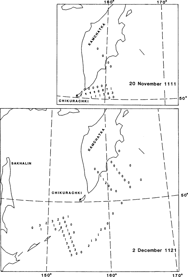 |
Figure 2. Preliminary SO2 data from the Nimbus-7 TOMS on 20 November 1986 at 1111 (top) and 2 December 1986 at 1121 (bottom). On 20 November the average column density is in units of 15 milliatmosphere-cm (150 ppm-m): 0 = <15; 1 = 15-29; 2 = 30-44, etc. On 2 December the average column density is in units of 5 milliatmosphere-cm; 0 = <4; 1 = 5-9; 2 = 10-14, etc. Courtesy of Arlin Krueger. |
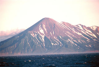
Geological Summary. Chikurachki, the highest volcano on Paramushir Island in the northern Kuriles, is a relatively small cone constructed on a high Pleistocene edifice. Oxidized basaltic-to-andesitic scoria deposits covering the upper part of the young cone give it a distinctive red color. Frequent basaltic Plinian eruptions have occurred during the Holocene. Lava flows have reached the sea and formed capes on the NW coast; several young lava flows are also present on the E flank beneath a scoria deposit. The Tatarinov group of six volcanic centers is located immediately to the south, and the Lomonosov cinder cone group, the source of an early Holocene lava flow that reached the saddle between it and Fuss Peak to the west, lies at the southern end of the N-S-trending Chikurachki-Tatarinov complex. In contrast to the frequently active Chikurachki, the Tatarinov centers are extensively modified by erosion and have a more complex structure. Tephrochronology gives evidence of an eruption around 1690 CE from Tatarinov, although its southern cone contains a sulfur-encrusted crater with fumaroles that were active along the margin of a crater lake until 1959.
Information Contacts: A. Krueger, GSFC.