Report on Kilauea (United States) — March 1987

Scientific Event Alert Network Bulletin, vol. 12, no. 3 (March 1987)
Managing Editor: Lindsay McClelland.
Kilauea (United States) Lava flow enters ocean; more coastal destruction
Please cite this report as:
Global Volcanism Program, 1987. Report on Kilauea (United States) (McClelland, L., ed.). Scientific Event Alert Network Bulletin, 12:3. Smithsonian Institution. https://doi.org/10.5479/si.GVP.SEAN198703-332010
Kilauea
United States
19.421°N, 155.287°W; summit elev. 1222 m
All times are local (unless otherwise noted)
The continuing production of pahoehoe flows . . . during March was primarily through the 12-km-long tube system that has been forming since July 1986. This system extends SE to the Kapa'ahu community that was largely overrun by lava in November 1986 (figure 48). Activity through the first half of March was confined mainly to the shield as spillover flows from the pond; a few sluggish breakouts occurred, generally above 450 m elevation. One flow reached 90 m altitude on 9 March.
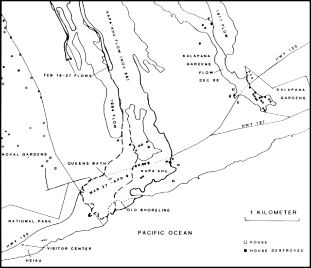 |
Figure 48. Sketch map showing the active lava flow on the Kalapana coast as of early May. The March-May 1987 flow is shown by a dashed line. |
On 24 March a new flow, fed from a tube opening at the 245 m level, overrode the Kapa'ahu flow, started a brush fire that burned an abandoned house W of the flow, and reached Highway 130 on 31 March. Queens Bath (a spring-fed fissure that was a popular swimming hole), and a nearby heiau (ancient Hawaiian temple) were also overrun on the same day. On 6 April, a small lobe stagnated within 5 m of an abandoned house within the kipuka N of Kapa'ahu, but it remained unharmed as of 9 April.
On 7 April, the first tongue of a broad westward-moving flow penetrated the E boundary of the national park (figure 48). By 0700 on 8 April, lava had blocked the entrance to Royal Gardens, closing the subdivision to all vehicle traffic. More than a kilometer of Hwy 130, which had reopened in February following late 1986 closing by the Kalapana Gardens and Kapa'ahu flows, was largly overrun by new flows. On 9 April at about 0200, lava entered the sea for the second time since . . . January 1983.
The height of the shield at the vent area reached 48 m above the pre-1983 surface. There has been no significant change in the summit tilt record since July.
Harmonic tremor continued at a low level in the East rift zone. Minor variations in amplitude occurred, generally at intervals of a few hours. Shorter tremor bursts and shallow microshocks from crustal adjustments and degassing associated with the lava activity were commonly recorded by seismometers within a few kilometers of the vent. The number of earthquakes was low in the summit region and moderate along the S flank.
Geological Summary. Kilauea overlaps the E flank of the massive Mauna Loa shield volcano in the island of Hawaii. Eruptions are prominent in Polynesian legends; written documentation since 1820 records frequent summit and flank lava flow eruptions interspersed with periods of long-term lava lake activity at Halemaumau crater in the summit caldera until 1924. The 3 x 5 km caldera was formed in several stages about 1,500 years ago and during the 18th century; eruptions have also originated from the lengthy East and Southwest rift zones, which extend to the ocean in both directions. About 90% of the surface of the basaltic shield volcano is formed of lava flows less than about 1,100 years old; 70% of the surface is younger than 600 years. The long-term eruption from the East rift zone between 1983 and 2018 produced lava flows covering more than 100 km2, destroyed hundreds of houses, and added new coastline.
Information Contacts: G. Ulrich, C. Heliker, and R. Koyanagi, HVO.