Report on Ketoi (Russia) — April 1987
Scientific Event Alert Network Bulletin, vol. 12, no. 4 (April 1987)
Managing Editor: Lindsay McClelland.
Ketoi (Russia) Fumarolic activity
Please cite this report as:
Global Volcanism Program, 1987. Report on Ketoi (Russia) (McClelland, L., ed.). Scientific Event Alert Network Bulletin, 12:4. Smithsonian Institution. https://doi.org/10.5479/si.GVP.SEAN198704-290200
Ketoi
Russia
47.35°N, 152.475°E; summit elev. 1172 m
All times are local (unless otherwise noted)
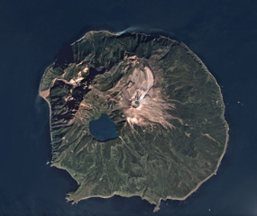
Moderate fumarolic activity was noted on the outer N slope of Pallas Peak's main crater area during an 11 October aerial survey.
Geological Summary. The circular 10-km-wide Ketoi island, which rises across the 19-km-wide Diana Strait from Simushir Island, hosts of one of the most complex volcanic structures of the Kuril Islands. The rim of a 5-km-wide Pleistocene caldera is exposed only on the NE side. A younger stratovolcano forming the NW part of the island is cut by a horst-and-graben structure containing two solfatara fields. A 1.5-km-wide freshwater lake fills an explosion crater in the center of the island. Pallas Peak, a large andesitic cone in the NE part of the caldera, is truncated by a 550-m-wide crater containing a brilliantly colored turquoise crater lake. Lava flows from Pallas Peak overtop the caldera rim and descend nearly 5 km to the SE coast. The first historical eruption of Pallas Peak, during 1843-46, was its largest.
Information Contacts: G. Steinberg and B. Piskunov, Yuzhno-Sakhalinsk.