Report on Kilauea (United States) — April 1987

Scientific Event Alert Network Bulletin, vol. 12, no. 4 (April 1987)
Managing Editor: Lindsay McClelland.
Kilauea (United States) Lava advance continues, three more houses destroyed
Please cite this report as:
Global Volcanism Program, 1987. Report on Kilauea (United States) (McClelland, L., ed.). Scientific Event Alert Network Bulletin, 12:4. Smithsonian Institution. https://doi.org/10.5479/si.GVP.SEAN198704-332010
Kilauea
United States
19.421°N, 155.287°W; summit elev. 1222 m
All times are local (unless otherwise noted)
The flow that entered the ocean on 9 April continued intermittently until 1400 on 21 April. Advance into the ocean has been sporadic and relatively minor in overall volume. Lava flows continued to advance, covering the November Kapa'ahu flow and spreading W over new ground. The main flow front continued to advance W into Hawaii Volcanoes National Park, overrunning more of . . . Hwy 130 and the entrance road to Royal Gardens subdivision. About 1.6 km of Highway 130 had been covered by late April. The small untouched area (kipuka) surrounded by the November lava flow has been slowly invaded and three more homes were destroyed by early May. A broad flow on the W side of the 1984 lava slowly advanced S and reached 43 m elevation (figure 48). Brush fires set by this flow generated heavy smoke, but have not threatened the Royal Gardens subdivision.
The level of the lava pond over the vent (figure 49) fluctuated from overflowing on 16-17 April to as much as 5 m below the rim. The pond was ~150 x 250 m, including the neck that leads to the main tube system. Tumescence occurring on the flanks of the ~52-m-high shield preceded lava breakouts and formation of fissures that emitted short aa flows. However, most movement of lava was through the underground tube system to the SE, visible through windows or skylights from ~660-40 m elevation.
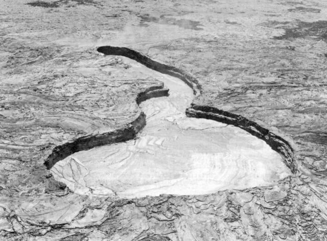 |
Figure 49. Photograph showing the active lava pond on the shield formed on Kīlauea's East rift zone since July 1986. The lava level is 3-4 m below the rim. Courtesy of J.D. Griggs, USGS. |
There was no significant change in summit tilt. Harmonic tremor persisted in the East rift zone with some minor changes in amplitude at intervals of a few hours. Short tremor bursts 1-3 minutes in duration occurred intermittently. The number of microearthquakes in the summit area and East rift zone was slightly above average. Earthquakes of M 1.5-3.0 occurred beneath the SE flank of Mauna Loa (Kaoiki fault) and the S flank of Kīlauea.
Geological Summary. Kilauea overlaps the E flank of the massive Mauna Loa shield volcano in the island of Hawaii. Eruptions are prominent in Polynesian legends; written documentation since 1820 records frequent summit and flank lava flow eruptions interspersed with periods of long-term lava lake activity at Halemaumau crater in the summit caldera until 1924. The 3 x 5 km caldera was formed in several stages about 1,500 years ago and during the 18th century; eruptions have also originated from the lengthy East and Southwest rift zones, which extend to the ocean in both directions. About 90% of the surface of the basaltic shield volcano is formed of lava flows less than about 1,100 years old; 70% of the surface is younger than 600 years. The long-term eruption from the East rift zone between 1983 and 2018 produced lava flows covering more than 100 km2, destroyed hundreds of houses, and added new coastline.
Information Contacts: C. Heliker and R. Koyanagi, HVO.